This section contains maps that cover all of Central American. For detailed mapping of each country, including road and topographic maps, please click the individual country listings below.
Belize Costa Rica El Salvador Guatemala Honduras Mexico Nicaragua Panama
Central America Travel Map. 1:1,800,000. ITMB, Canada.
An excellent shaded relief map covering Guatemala to Panama. More detailed than 66-2391 above, but does not cover MexicoCaribbean.
$12.95
66-2392
1 sheet, folded
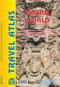
Mayan World road atlas. Variable scales. ITMB.
The Mayas occupied the Yucatan Peninsula and spread inland through modern-day Belize, Guatemala, and Honduras all the way to El Salvador. This atlas covers all these areas: Mexico from Tabasco and Chiapas, through the Yucatan provinces of Campeche, Quintana Roo and Yucatan (1:500,000), all of Belize at 1:250,000, all of Guatemala at 1:470,000, all of Honduras at 1:750,000, and all of El Salvador at 1:250,000. The advantage of this travel atlas is that all of these countries are available in one convenient-to-carry book. Each known Mayan site is marked and named (there are more than 400) in magenta. City maps of Antigua Guatemala, Guatemala City, San Salvador, Tegucigalpa, and Belize City are included in this comprehensive atlas.
Sample detail of the Mayan World road atlas
Central America Wall Map. 1:4,500,000. 1993. Ryborsch.
This map covers Mexico, Central America, and the Caribbean. We recommend this map for an overview of the "Middle America" region. Multilingual.
Sample of the Central America wall map detail
$19.95
66-23926
1 sheet, rolled/flat
$34.95
66-23926L
Laminated
Large Earthquakes of North and Central America: 1970-1996. USGS.
This large wall map (45 x 42") displays earthquakes that have ocurred in or near North and Central America during 1970-1996.
The epicenter symbol sizes are scaled into three magnitude categories: magnitudes 5.0-5.9, magnitudes 6.0-6.9, and magnitudes 7.0 and greater.
The epicenter symobls are color-coded to indicate shallow and deep earthquakes. Base map from Raven Maps.


 Sample detail of the Mayan World road atlas
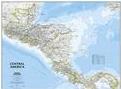
 View of the front of the map.
 Detailed view of part of the map.
 Detailed view of the scale bar of the map.
 An enlarged view of the mounted map
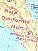
 Sample of the Central America wall map detail