Alberta Maps


Banff North hiking map
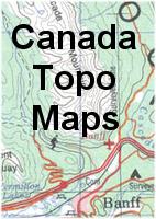
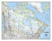
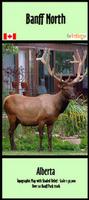
New titles
Alberta Hiking and Backroads Maps from GoTrekker. GoTrekker. These maps, all plot-on-demand, cover many of the beautiful back-country areas of Canada. The maps use symbols to loate sugggested routes, alternative routes, trails, restaurants, hoels, gas stations, campgrounds, and much more. Printed on paper unless noted otherwise.
Sample detail from a small-scale map: 64-2776-1, Alberta Backroads Map #1.
Sample page a 1:50,000 scale map: 64-2776-BAA Banff and Area.
Sample page a 1:50,000 scale map: 64-2776-MA Mount Assiniboine .
Index map as a .pdf file
Ordering (Can) Alberta Backroads Map #1 (GoTrek)$14.9564-2776-1Alberta Backroads Map #1. Forestry Trunk Road from Waterton to Old Man River. 1:125,000. ISBN 9781926546902.
Ordering (Can) Alberta Backroads Map #2 (GoTrek)$14.9564-2776-2Alberta Backroads Map #2. Forestry Trunk Road from Old Man River Forestry Road to Canmore. 1:125,000. ISBN 9781926546391.
Ordering (Can) Alberta Backroads Map #3 (GoTrek)$14.9564-2776-3Alberta Backroads Map #3. Forestry Trunk Road from Ghost Dam to Peppers Lake. 1:125,000. ISBN 9781926546810.
Ordering (Can) Alberta Backroads Map #4 (GoTrek)$14.9564-2776-4Alberta Backroads Map #4. Forestry Trunk Road from Peppers Lake to Fairfax Lake. 1:125,000. ISBN 9781926546803.
Ordering (Can) Alberta Backroads Map #5 (GoTrek)$14.9564-2776-5Alberta Backroads Map #5. Forestry Trunk Road from Fairfax lake to Hinton. 1:125,000. ISBN 9781926546773.
Ordering (Can) Banff & Area map (GoTrek)$13.9564-2776-BAABanff & Area Map. 1:50,000. 2013. With over 100 official Park trails. ISBN 9781926698427.
Ordering (Can.) Banff & Canmore area map (GoTrek)$13.9564-2776-BACBanff & Canmore Area Map. 1:50,000. 2013. With over 70 official Banff & Kananaskis Park trails. ISBN 97819265456377.
Ordering (Can.) Banff North, Ya Ha Tinda map (GoTrek)$13.9564-2776-BANBanff North and Ya Ha Tinda Ranch Area Map. 1:50,000. 2013. With over 20 official Park trails. ISBN 9781897482322.
Ordering (Can) Jasper & Area map (GoTrek)$13.9564-2776-JAJasper & Area Map. 1:50,000. 2013. Over 70 official Park trails. ISBN 9781926698502.
Ordering (Can) Jasper - Maligne Lake map (GoTrek)$13.9564-2776-JMLJasper & Maligne Lake Map. 1:125,000. 2014. ISBN 9781897482674.
Ordering (Can.) Jasper & Mount Robson map (GoTrek)$12.9564-2776-JMRJasper & Mount Robson Map. 1:50,000. 2013. ISBN 9781926698519.
Ordering (Can.) Jasper West & Miette Pass map (GoTrek)$12.9564-2776-JWMJasper West & Miette Pass Map. 1:50,000. 2013. ISBN 9781926698526.
Ordering (Can.) Kananaskis NE map (GoTrek)$13.9564-2776-KNEKananaskis Northeast Map. Little Elbow Provincial Park to Barrier Lake to Bragg Creek. 1:40,000. 2012. ISBN 9781926698489.
Ordering (Can.) Kananaskis NW map (GoTrek)$13.9564-2776-KNWKananaskis Northwest Map. Fortress Mountains to Canmore. 1:40,000. 2013. ISBN 9781926698465.
Ordering (Can.) Kananaskis SE map (GoTrek)$13.9564-2776-KSEKananaskis Southeast Map. Little Elbow Provincial Park to Mist Creek to Sandy McNabb. 1:40,000. 2012. ISBN 9781926698472.
Ordering (Can.) Kananaskis SW map (GoTrek)$13.9564-2776-KSWKananaskis Southwest Map. Elk Lakes to Fortress Mountain and Peter Lougheed Provincial Park. 1:40,000. 2013. ISBN 9781926698458.
Ordering (Can.) Lake Louise & Area map (GoTrek)$13.9564-2776-LLALake Louise & Area Map (AB/BC). 1:50,000. 2012. With over 100 official Park trails. ISBN 9781926698441.
Ordering (Can.) Lake Louise North map (GoTrek)$13.9564-2776-LLNLake Louise North Map. 1:50,000. 2012. With 30 official Park trails. ISBN 9781926546896.
Ordering (Can.) Lake Louise & Skoki Area map (GoTrek)$12.9564-2776-LLSLake Louise & Skoki Area Map. 1:35,000. 2013. ISBN 9781926546179.
Ordering (Can.) Mount Assiniboine & Area map (GoTrek)$16.9964-2776-MAMount Assiniboine & Area Map. 1:50,000. 2013. ISBN 9781897482391.
Ordering (Can.) No. Saskatchewan River #1 (GoTrekker)$13.9564-2776-NS1North Saskatchewan River Map #1. 1:50,000. Drayton Valley to Former Genessee Ferry. Designed for canoe, kayak, and floaters. No ISBN.
Ordering (Can.) No. Saskatchewan River #2 (GoTrekker)$13.9564-2776-NS2North Saskatchewan River Map #2. 1:50,000. Former Genessee Ferry to Devon. Designed for canoe, kayak, and floaters. No ISBN.
Ordering (Can.) No. Saskatchewan River #3 (GoTrekker)$13.9564-2776-NS3North Saskatchewan River Map #3. 1:50,000. Devon to Edmonton. Designed for canoe, kayak, and floaters. No ISBN.
Ordering (Can.) No. Saskatchewan River #4 (GoTrekker)$13.9564-2776-NS4North Saskatchewan River Map #4. 1:50,000. Edmonton to Pakan. Designed for canoe, kayak, and floaters. No ISBN.
Ordering (Can.) No. Saskatchewan River #5 (GoTrekker)$13.9564-2776-NS5North Saskatchewan River Map #5. 1:50,000. Pakan to Myrnam. Designed for canoe, kayak, and floaters. No ISBN.
Ordering (Can.) No. Saskatchewan River #6 (GoTrekker)$13.9564-2776-NS6North Saskatchewan River Map #6. 1:50,000. Myrnam to Saskatchewan border. Designed for canoe, kayak, and floaters. No ISBN.
Ordering (Can.) Peyto - Wapta Area map (GoTrekker)$13.9564-2776-PEPeyto - Wapta Area Map. 1:40,000. 2013. ISBN 9781926546186.
Ordering (Can.) The Royal Group map (GoTrekker)$13.9564-2776-TRGThe Royal Group - Height of the Rockies Provincial Park Map. 1:50,000. 2013. ISBN 9781897482339.
Ordering (Can.) Waterton N.P. map (GoTrekker)$13.9564-2776-WATWaterton National Park Map. 1:40,000. 2011. ISBN 9781926546957.
Ordering (Can.) Whaleback & Bob Creek Wildland map (GoTrek)$13.9564-2776-WHAWhaleback & Bob Creek Wildland Map. 1:40,000. 2013. ISBN 9781926546827.
Ordering (Can.) Willmore Wilderness Prov. Park Map (GoTrek)$16.9564-2776-WILWillmore Wilderness Provincial Park Map (AB/BC). 1:125,000. 2013. ISBN 9781926546100.

Links to other Canadian maps:

      Canada Road Maps, City Maps, and Atlases

    • Canada Road & Street Atlases

    • Canada Province Road and Recreation Maps - Paper

    • Canada Province Road Maps - Laminated

    • Canada City Street Maps - Paper

    • Canada City Street Maps - Laminated
    • Canada Hiking Maps & Atlases

    • Canada Backroads Mapbooks. Topographic recreation road atlases.

    • National Park Maps by GoTrekker. Many maps for the northern National Parks.

    • Gem Trek hiking maps. Hiking/topo maps of Banff N.P., Jasper N.P., etc.

    • Chrismar hiking and canoeing maps.

    • Hiking Maps by ITMB.
    • Canada Fishing Maps
      Canada Raised Relief Maps

    • Backroads Fishing Atlases.

    • Canada Lake/river fishing maps.

    • Canada Raised Relief Maps.
    • Canada Topographic Maps

    • Canada 1:50,000 Topographic Maps. Itemized topo lists, index maps, sample images.

    • Canada 1:250,000 Topographic Maps. Itemized topo lists, index maps, sample images.

    • Canada 1:500,000 VNC Aeronautical/topographic maps.

    • Canada 1:1,000,000 WAC Aeronautical/topographic maps.
    • Canada Wall Maps
      Canada Railway Maps
      Canada Geology Maps

    • Canada Wall Maps.

    • Canada Satellite Image Posters.

    • Canada Railway Maps and Atlas.

    • Canada & Provincial Geologic and Thematic Maps .
    • Canada Flags
      Map Pins & Map Flags
      Gifts for Map Lovers

    • Canada Flags.

    • Map Pins, Map Tacks, Map Flags.

    • Gifts for the Map Enthusiast.


    • image

      © Copyright 2025 East View Companies, Inc.
      5130 Industrial Street, Suite 100, Maple Plain, MN 55359-8005
      All Rights Reserved
      For more information please Contact Us