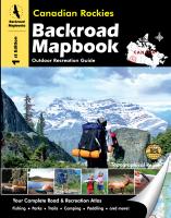
Topographic road atlases for Canada! Canadian Backroads Atlases. Backroad Map Books. These atlases offer coverage of Canada similar to the well-known DeLorme state atlases for the USA. These atlases are detailed atlases that show all of the backroads, including logging roads, etc. The newer atlases include contour lines on the maps, extensive tourist information, and much more.
Recreational Features: Trail systems, symbols, management units and more
Road Features: Complete classified road systems, road names and more
UTM Grid & Longitude and Latitude: both grids are included for GPS users
Reference Section: Comprehensive write up on Fishing, Paddling, Parks, Trails, Winter Recreation and more
British Columbia Province & Rockies Atlases:
$33.99
64-26940-19
Canadian Rockies Backroads Atlas.
$29.99
64-26940-05
Cariboo Chilcotin Coast of BC Backroads Atlas.
$29.99
64-26940-04
Kootenays Rockies Backroads Atlas.
$29.99
64-26940-20
Northern British Columbia Backroads Atlas.
$29.99
64-26940-21
Thompson and Okanagan Backroads Atlas.
$32.99
64-26940-02
Vancouver Islands, Victoria, and Gulf Islands Backroads Atlas.
$32.99
64-26940-22
Vancouver, Coast and Mountains Backroads Atlas.
Prairie Provinces (Alberta, Manitoba, Saskatchewan)
$29.99
64-26940-15
Northern Alberta Backroads Atlas.
$29.99
64-26940-12
Central Alberta Backroads Atlas.
$37.99
64-26940-16
Southern Alberta Backroads Atlas.
$29.99
64-26940-17
Manitoba Atlas.
$29.99
64-26940-29
Saskatchewan Backroads Atlas.
Ontario Province
$29.99
64-26940-09
Ontario & Algonquin Cottage Country Backroads Atlas.
$29.99
64-26940-10
Eastern Ontario Backroads Atlas.
$29.99
64-26940-11
Northeastern Ontario Backroads Atlas.
$34.99
64-26940-23
Northwestern Ontario Backroads Atlas.
$32.99
64-26940-SON
Southern Ontario Backroads Atlas. .
Atlantic Provinces (Quebec, Nova Scotia, New Brunswick, Prince Edward Island)
$29.99
64-26940-25
Southwestern Quebec Backroads Atlas.
$34.99
64-26940-26
New Brunswick & Prince Edward Island Backroads Atlas. 1:200,000.
$34.99
64-26940-NEW
Newfoundland & Labrador Backroads Atlas. 1:250,000 and 1:1,000,000.
$34.99
64-26940-27
Nova Scotia & Prince Edward Island Backroads Atlas. 1:200,000.
Canada Hiking Maps
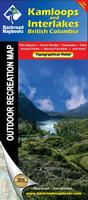
Waterproof! Canada Hiking Maps. Backroads Mapbooks. The Backroad Recreation Maps are the ideal explorer maps of BC and Ontario. Highlighting popular recreational areas on large format, tear resistant and waterproof paper, these topographical maps are built to withstand all Mother Nature can throw at you. Easier to read than a traditional mapbook, we also added fish species and local service providers. Other notable features include hunting management units, logging roads or bush road systems, trails, parks and boat launches as well as ATV and snowmobile routes.
Printed on tear resistant and waterproof large format (70 cm x 100 cm/28" x 40") paper
Larger scale maps allowing for easier readability of text
The most up-to-date topographic maps available in Canada
Fish species for lakes and rivers
Local retailers and service providers
Color road classifications distinguishing paved roads from logging roads
Labeled roads, trails and recreational features
Trail systems, including defined ATV, snowmobile & multi-use trail systems
Park and backcountry campsites
Paddling routes including access points and portages
Wildlife management boundaries for anglers and hunters
Wildlife viewing sites
Elevation relief shading with labeled contours to highlight mountains and river valleys
UTM Grids along with latitude and longitude bearings
Kamloops and Interlakes Hiking Map (British Columbia). 1:150,000.
$16.99
64-26942OK
Okanagan Valley Hiking Map (British Columbia). 1:150,000.
$16.99
64-26942PRI
Prince George and Mackenzie Hiking Map (British Columbia). 1:200,000.
Canada National Park Maps
Northern Canada National Park Hiking Maps on DVD for MemoryMap GPS software. Variable scale. GoTrekkers. This is the only map series to cover Canada's Northern National Parks. Available as either DVD for GPS use (MemoryMap .qct format) or as paper maps. The maps show Park Boundaries, contours, rivers, all with shaded relief.
$174.95
64-2874-CNP
DVD.
Canada National Park Hiking Maps. Variable scale. GoTrekkers. This is the only map series to cover Canada's Northern National Parks. The maps show Park Boundaries, contours, rivers, all with shaded relief. These are all plot-to-order maps, not litho-printed.
Sample of the Bowron Lakes map detail
$19.95
64-2874-AUL
Aulavik N.P., NWT. 1:210,000. Approx. 36 x 28".
$19.95
64-2874-AUY
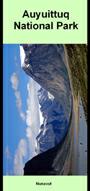
Auyuittuq N.P., Nunavut. 1:300,000. Approx. 36 x 24".
$12.95
64-2874-BAR
Barker Lake Canoe Map, Saskatchewan. Approx. 36 x 28".
$19.95
64-2874-BOW
Bowron Lakes N.P., BC. 1:50,000. Approx.
$19.95
64-2874-BUG
(BC) Bugaboo Provincial Park hiking map. 1:25,000. Size is 32 x 35".
$19.95
64-2874-CAM
(AB/BC) Campbell Icefields hiking map. 1:50,000. Four 1:50,000 topo sheets joined into a single sheet covering the Icefields. Size is 34 x 38".
$19.95
64-2874-GRE
Grasslands N.P., East Block, Saskatchewan. 1:50,000. Approx. 41 x 24".
$19.95
64-2874-GRW
Grasslands N.P., West Block, Saskatchewan. 1:50,000. Approx. 41 x 24".
$19.95
64-2874-IVV
Ivvavik N.P., Yukon. 1:150,000. Approx. 31 x 34".
$19.95
64-2874-KAK
(AB/BC) Kakwa Provincial Park hiking map. 1:100,000. Size is 27 x 41".
$19.99
64-2874-KLU
Kluane N.P., Yukon. 1:250,000 with 1:50,000 of Mt. Logan. Approx. 40 x 32"
$16.95
64-2874-LAK
Lake Diefenbaker & Area Map, Saskatchewan. 1:200,000. Approx. 40 x 29".
$19.95
64-2874-LLS
(AB) Lake Louise to Skoki Lodge hiking map. 1:35,000. Size is 23 x 40".
$16.95
64-2874-MAC
MacLennan Lakes Canoe Map, Saskatchewan. Approx. 40 x 28".
$19.95
64-2874-NAH
Nahanni N.P. Reserve, NWT. 1:250,000. Approx. 40 x 30".
$12.95
64-2874-OTT
Otter Lake Canoe Map, Saskatchewan.
$16.95
64-2874-PRI
Prince Albert N.P., Saskatchewan. 1:100,000. Approx. 40 x 28".
$19.95
64-2874-QUT
Quttinirpaaq N.P., Nunavut. 1:300,000. Approx. 36 x 24".
$59.95
64-2874-SA
(NWT) Sahtu North hiking map. 1:500,000. Size is 63 x 34".
$19.95
64-2874-SIR
Sirimilik N.P., Nunavut. 1:325,000. Approx. 36 x 24".
$19.95
64-2874-TUK
Tuktut Nogait N.P., NWT. 1:275,000. Approx. 36 x 27".
$19.95
64-2874-UKK
Ukkusiksalik N.P., Nunavut. 1:375,000. Approx. 36 x 21".
$19.95
64-2874-VUN
Vuntut N.P., Yukon. 1:125,000. Approx. 36 x 26".
$19.95
64-2874-WAP
Wapusk N.P., Manitoba. 1:250,000. Approx. 36 x 24".
$19.95
64-2874-WOO
Wood Buffalo N.P., NWT/Alberta. 1:375,000. Approx. 35 x 31".
Auyuittuq National Park - Akshayuk Pass Hiking Map. 1:65,000. Chrismar. Extraordinary backpacking/ski destination, 100km-long glacial valley crossing a portion of Baffin island in northern Canada, minimal facilities (emergency shelters), remote access by boat (or in winter by ski), challenging physical requirements for some routes, self-sufficiency required, extraordinary scenery, little wildlife, popular extreme rockclimbing destination, clean air and water, fascinating northern culture in access towns of Pangnirtung and Qikitarjuaq. 25 meter contours. Printed on waterproof, tear-resistant synthetic paper.
$19.99
64-26910-20
1 sheet, folded
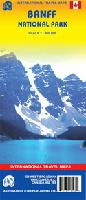
Banff National Park travel map. 1:300,000. ITMB, Hiking/topo map on waterproof paper. With detailed tourist information and an inset of Whistler Village.
Sample #1 Sample #2
$8.95
64-2774
1 sheet, folded
Whistler travel map. 1:50,000. ITMB. Hiking/topo map on waterproof paper. With detailed tourist information and an inset of Whistler Village.
$8.95
64-28909
1 sheet, folded
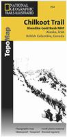
Waterproof! Chilkoot Trail & Klondike Hiking Map. Trails Illustrated #254. This two-sided map includes Chilkoot Trail National Historic Site, portions of the Klondike Highway, Chilkoot Trail, Chilkoot Pass / Parks Canada Warden Station, Happy Camp, Deep Lake, Lindeman City, Bare Loon Lake, Bennet, Crater Lake, Long Lake, Lindeman Lake, Bennett Lake, Summit Lake, Taiya Inlet, the town of Skagway, Klondike Gold Rush National Historical Park, Denver Glacier Trail, Skagway River, Dyea, and more. The map features insets of the Skagway Historic District, the Dyea townsite, and an inset showing the Skagway and Dyea Vicinity, as well is useful information about travelling to the area, customs, permits, fees, a suggested equipments list, reservations phone numbers, safety tips, and a section about the historic routes to the Klondike. This includes information about Chilkoot Pass, White Pass, the Yukon River route, the Valdez route, Yakutat Bay Trail, Stikine River, the Ashcroft Trail, and Edmonton Trails. Includes UTM tick marks for use with your GPS unit.
Sample detail from the Klondike hiking map.
$14.95
63-2100-254
1 sheet, folded
Canada Recreation Maps. ITMB. ITMB publishes a good quality map series of western Canadian recreational areas.
64-2774
$8.95
Banff National Park. 1:300,000.
64-36913
$9.95
British Columbia South. 1:925,000.
64-28901
$14.95
Gulf Islands and Nanaimo. 1:50,000.
64-2775
$12.95
Jasper National Park. 1:250,000.
64-28905
$9.95
Queen Charlotte/Haida Gwaii Islands. 1:250,000.
64-28914
$5.95
Stein Valley (BC). 1:66,000.
64-28917
$11.95
Thompson/Cariboo region. 1:250,000.
64-28916
$8.95
Vancouver Island. 1:400,000.
64-28906
$11.95
Vancouver Island's West Coast Trail. 1:50,000. Waterproof.
64-28907
$9.95
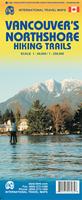
Vancouver Island's North Shore Hiking Trails. 1:40,000. The Coquitlam Watershed is included on the map. Includes inset maps of Cypress Provincial Park, Capilano River Regional Park and Lynn Canyon.


 Waterproof!
 Sample detail of the Kamloops Hiking Map
 Sample detail of the Okanagan Valley Hiking Map
 Sample detail from the East Kootenay hiking map
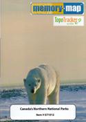

 Sample of the Bowron Lakes map detail
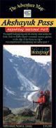
 Sample #1
 Sample #2
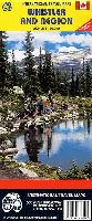

 Waterproof!
 Sample detail from the Klondike hiking map.