Canadian Fishing Atlases. Backroad Map Books. These atlases include detailed lake and river maps. The lake depth charts and river maps will help you read a lake to spend less time travelling on the water and more time fishing the hot spots. Add in the helpful fishing tips, access details and the information on facilities and you have all the details you need to fish the lake or stream with confidence. The best Canadian Fishing mapbooks guaranteed!
Lake Charts: Contour map or depth chart provided for each lake
Road Features: Complete classified road systems, road names and more
Longitude and Latitude: for GPS user
Reference Section: Comprehensive write up on Fishing, Access Info, Facilities, Stocking Info and more
$33.99
64-26930-08
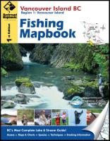
Vancouver Island Fishing Atlas. Includes coverage of these parks/regions/cities: Campbell River, Comox, Courtenay, Duncan, Gold River, Nanaimo, Parksville, Port Alberni, Port Hardy, Port Renfrew, Tofino, and Victoria.
$33.99
64-26930-09
Southwestern B.C. Fishing Atlas. Includes coverage of these parks/regions/cities: Boston Bar, Cache Creek, Chilliwack, Clearwater, Gold Bridge, Hope, Kamloops, Little Fort, Powell River, Pemberton, Salmon Arm, Vancouver, and Whistler.
$33.99
64-26930-10
Southeastern B.C. Fishing Atlas. Includes coverage of these parks/regions/cities: Cranbrook, Creston, Fernie, Golden, Grand Forks, Invermere, Kaslo, Kelowna, Nakusp, Nelson, Osoyoos, Princeton, Penticton, Revelstoke, Trail, and Vernon.
$33.99
64-26930-11
Northern B.C. Fishing Atlas. Includes coverage of these parks/regions/cities: 100 Mile House, Atlin, Bella Coola, Dawson Creek, Fort Nelson, Prince George, Prince Rupert, Quesnel, Smithers, Terrace, and Williams Lake.
$33.99
64-26930-12
Central Ontario Fishing Atlas. Includes coverage of these parks/regions/cities: Algonquin Park, Arnprior, Bancroft, Bracebridge, Deep River, Gravenhurst, Haliburton, Huntsville, Minden, Parry Sound, Pembroke, Petawawa, Renfrew, and Whitney.
$33.99
64-26930-13
Eastern Ontario Fishing Atlas. Includes coverage of these parks/regions/cities: Arnprior, Belleville, Bon Echo, Carleton Place, Cornwall, Kingston, Madoc, Ottawa, and Perth.
$33.99
64-26930-14
Haliburton, Ontario Fishing Atlas. Includes coverage of these parks/regions/cities: Bobcaygean, Dorset, Haliburton, Kinmount, Minden, and Moore Falls.
Alberta Fishing Maps
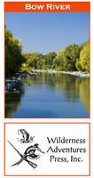
Alberta River Fishimg Maps by Wilderness Adventures Press. An essential tool for a successful fly-fishing trip is a detailed map of the water. One that will give you the access points, boat launches, campgrounds, public areas, roads, and GPS coordinates to pinpoint your location.
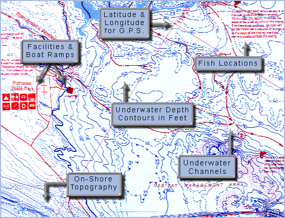
Fish-N-Map Company underwater topography maps are printed on a
waterproof, tear-resistant material and are folded to 9" x 4". When opened, each map is approximately
3' x 2' in size and is printed on both sides. These maps feature waterproof plastic "paper"; underwater
depth contours; fish locations; latitude and longitude for GPS; often multiple lakes on one map; boat
ramps; recreational facilities; and much more.
Campbell River to Port Hardy fishing map. 5 meter contours.
$16.95
64-2693-FR
Fraser River (Vancouver to Hope, including Pitt & Harrison Lakes) fishing map. 5 meter contours.
$16.95
64-2693-GE
Strait of Georgia, Vancouver & Namaimo to Courtenay and Powell River fishing map. 5 meter contours.
Ontario Fishing Maps
Ontario (Canada) Fishing Maps by Fishing Hot Spots
$14.95
64-2693-M473
Bay of Quinte-East fishing map. Lake Ontario, Telegraph Narrows- Upper Gap. Out of print and only available while supplies last.
$13.95
64-2693-M498
Bay of Quinte-West fishing map. Lake Ontario, Trenton-Telegraph Narrows. Out of print and only available while supplies last.
$14.95
64-2693-Q280
Eagle Lake fishing map.
$14.95
62-8493-M485
Lake Erie-Eastern Basin fishing map. Sturgeon Point-Peace Bridge-Point Abino.
$14.95
64-2693-Q274
Rainy Lake North fishing map.
$14.95
64-2693-Q275
Rainy lake South fishing map.
$14.95
64-2693-Q270
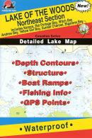
Lake of the Woods-Northeast fishing map. Includes Kenora, Keewatin, Kenora Bay, Rat Portage Bay, Witch Bay, Andrew Bay, Moore Bay, Bigstone Bay.
$14.95
62-8493-S277
St. Lawrence River-West fishing map. 1000 Islands, Lake Ontario, Howe Islands.
$14.95
62-8493-S278
St. Lawrence River-Central fishing map. 1000 Islands, Howe Islands, Wellesley Islands.
$14.95
62-8493-S279
St. Lawrence River-East fishing map. 1000 Islands, Wellesley Islands, Chippewa Bay.
$14.95
64-2693-Q271
Lake of the Woods-Northwest fishing map. Includes Clearwater Bay, Labyrinth Bay, Monument Bay, Boggy Bay,Big Narrows Island, Portage Narrows, Ptarmigan Bay.
$14.95
64-2693-Q272
Lake of the Woods-Southeast fishing map. Includes Sioux Narrows, Nestor Falls, Miles Bay, Long Bay, Whitefish Bay, Sabaskong Bay, Regina Bay, Lobstick Bay.
$14.95
64-2693-Q273
Lake of the Woods-Southwest fishing map. Includes Big & Little Traverse Bays, Oak Island, Bigsby Island, Miles Bay, Big Island, NW Angle.


 Front of the Bow River fishing map
 Sample detail from the front of a river map from this series (Deschutes River)
 Sample detail from the back of a river map from this series (Truckee River)
 A sample of a map legend.