Listed below are maps that cover the Middle East. Detailed maps and topographic mapping are listed in each country's listings - please see the links below.
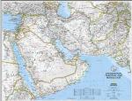
Middle East map. 1:6,087,000 National Geographic Maps.
This finely detailed political map shows up-to-date country boundaries and place names, as well as beautiful shaded relief.
The map covers a broad geographic area ranging from northern Africa through the Middle East to the western edge of China and India. Includes complete coverage of Afghanistan, Pakistan, Tajikistan, Iran, Iraq, Kuwait, Syria, Israel, Jordan, Lebanon, Saudi Arabia, Qatar, Bahrain, United Arab Emirates, Yemen, Oman, Cyprus, and Eritrea.
Also includes parts of India, China, Kyrgyzstan, Uzbekistan, Turkmenistan, Azerbaijan, Armenia, Turkey, Egypt, Sudan, Ethiopia, and Djibouti. Measures 20 x 27".
NOTE: This map, when mounted, has a $25 shipping charge for continental US destinations, higher charges apply for other destinations.
An image of the full map A detail of the map An enlarged view of the mounted map
$14.99
64-0646
Flat/rolled.
$24.99
64-0646L
Laminated.
$169.95
64-0646BL
Mounted, black.
$169.95
64-0646GO
Mounted, gold.
$169.95
64-0646WH
Mounted, white.
$169.95
64-0646WO
Mounted, wood-grain.
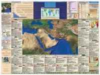
The Middle East - Educational Wall Poster. The best educational, informative poster of the Middle East that we've seen.
A superb, laminated poster that shows the entire Middle East, numerous informative charts and diagrams, and inset maps of Iraq, Afghanistan, and Israel. Click here to see sample images and more detailed information.
$29.95
66-2148
Middle East poster, flat/rolled.
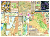
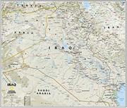
Iraq & the Heart of the Middle East. National Geographic Maps. This timely two-sided map of Iraq and the Middle East features a wealth of geographic, political, natural resource, and cultural information.
The front of the map features an incredibly accurate, detailed map of political boundaries, cities and towns, major roadways, bodies of water, oil fields and pipelines, and other geographic features. Side One also includes city insets that show street plans and describe the history and cultures of Baghdad, Beirut, Damascus, and Jerusalem.
The map's reverse side shows an eye-catching satellite view of the region, as well as fact boxes that show each country's flag, population, economy, oil reserves, military strength, and include a brief historical and cultural description of each country. Three thematic maps also cover the region's historical conflicts, geographic concentrations of religions, and natural resources.
Measures 36" x 23". Scale: 1 inch = 31 miles.
Thumbnail view of the entire map. Detailed view of part of the map. An enlarged view of the mounted map
$14.99
64-79485
Iraq map, flat/rolled.
$19.99
64-79485L
Iraq map, laminated.
$169.95
64-79485BL
Iraq map, mounted, black.
$169.95
64-79485GO
Iraq map, mounted, gold.
$169.95
64-79485WH
Iraq map, mounted, white.
$169.95
64-79485WO
Irtaq map, mounted, wood-grain.
Middle East Travel and Road Maps
Middle East Road Atlas. Scales vary. ITMB, 1st edition, 5/2012. Countries included in this Atlas are: Syria, Lebanon, Israel, Jordan, Iraq, Saudi Arabia, Yemen, U.A.E, Oman, Kuwait, Bahrain, and Qatar. Items shown on the map and in the legend include Roads by classification, Airports, Seaports, Ferries, Border Crossings, World Heritage Sites, Point of Interest, Museums, Monuments, Forts/Castles, Mosques, Churches, Synagogues, Hospitals, Embassies, Universities/Colleges, Mining, Rivers and Lakes, Parks, Viewpoints, Industries, Historic Sites and much more. ISBN 9781553410867.
Sample detail of the Middle East road atlas
$19.95
66-21906
1 sheet, folded.
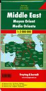
Middle East Map. 1:2,000,000. Freytag & Berndt. Regional map showing the main roads of the Middle East, from eastern Egypt and Istanbul eastward to Tehran and Shiraz, and from Cairo and Shiraz in the south northward to just north of Istanbul and Tbilisi. This is not the most detailed map but it is quite useful as an overview of the eastern Mediterranean and Middle East region.
Sample detail from the Middle East map. Shows map coverage of the Middle East Map.
$15.95
66-2171
1 sheet, folded.
Waterproof! Middle East Travel Map. 1:1,200,000. Reise Know-How. This double-sided map covers from Cairo to Kuwait. The map covers north-eastern Egypt, Sinai Peninsula, Israel, Palestinian Territories, Jordan, northwestern Saudi Arabia, Syria, Iraq, Kuwait, and Cyprus. ISBN 9783831772407.
Sample detail of the Middle East Map
$15.99
66-21903
1 sheet, folded.
The Persian Gulf Map. 1:2,000,000. Freytag & Berndt. This road map covers Iran, Iraq and The Persian Gulf. It uses shaded relief to portray the general relief and various landscapes distinguished such as desert, marsh, and salt lakes. The south-eastern extremity of Iran is depicted in an inset map.
Roads are clearly classified and intermediate driving distances are shown. Other details include spot heights, watering points or wells in the desert, airports, border crossings-points, railways and sites of antiquities. Latitude and longitude lines are shown at 2° intervals. Multilingual legend, index on reverse.
Shows map coverage.
$15.95
66-2171
1 sheet, folded.
Recommended! Middle East Travel map. 1:3,500,000. Cartographia. Excellent map showing physical geography of the Middle East region. Multilingual. Also available as a flat edition ideal for classrooms, etc. 32-1/2 x 46-1/2".
$4.95
66-21925
Each, folded (1990 edition).
$7.95
66-21926
Each, flat/rolled (1990 edition).
$12.99
66-21927
Each, folded (1999 edition).
Middle East Travel Map. 1:4,000,000. Geoprojects. Includes time zone map; with some tourist information.
Sample #1
$19.99
66-2192
1 sheet, folded
Arab World Maps. GEOprojects, Reading. GeoProjects specializes in maps of the Arab World and arab countries. Please see the individual country for country maps.
$20.95
66-1770
Arabia. 1:3,000,000. Side one has a topographic map including oil pipelines, settlements, etc. Side two has an index of place names and individual country profiles. Size is 88 x 78 cm.
$12.95
67-10912
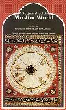
Muslim World. Side one has a Map of the World at 1:35,000,000 showing international boundaries and settlements with countries colored according to percentage Muslim population. Side two has a chart showing Muslim population totals and percentages in each country. Size is 44 x 78 cm.
$21.95
67-10911
Arab World. 1:10,000,000. Side one shows relief shading, communications, oilfields and pipelines, settlements, and an index of place names. Side two has general text about the region and the countries. Size is 55 x 91 cm.
The Political & Historical Map of the Persian Gulf. 1:1,000,000. Gita Shenassi #192. A large colorful map showing the various nations along the Persian Gulf; villages and towns; shipping routes; locations of oil platforms in the Gulf; airports; ports; and much more. Bilingual throughout. Size is 39 x 54".
 An image of the full map
 A detail of the map
 An enlarged view of the mounted map
 Thumbnail view of the entire map.
 Detailed view of part of the map.
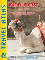
 Sample detail of the Middle East road atlas
 Sample detail from the Middle East map.
 Shows map coverage of the Middle East Map.
 Waterproof!
 Sample detail of the Middle East Map

 Shows map coverage.
 Sample #1