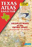
Texas Topographic Atlas & Gazetteer. DeLorme.
Detailed topographic and road map atlas. Includes Forest Service roads, information on state and local campgrounds, and more.
$29.95
62-9548
Atlas
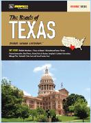
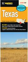
Roads of Texas Atlas. Mapsco.
The Roads of Texas Atlas is a full-color regional atlas, including: detailed Attractions and Places of Interest, information on Famous Texans, Festival information, Ghost Towns, Historic Forts and Missions, Longitude and Latitude Information, a mileage chart, National and State Parks, and a Texas Counties inset. Softcover, 11 x 15 inches.
$29.99
62-95483
Atlas.
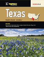
Texas Road Atlas. Mapsco.
The Texas State Atlas is a full-color regional atlas, including: City insets, County Map, Festivals & Events, Longitude & Latitude Information, Mileage Chart, Places of Interest, State & National Parks. Spiral-bound. Size is 8.5 x 11 inches.
$22.99
62-95481
Atlas.
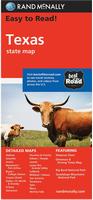
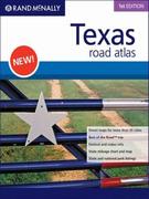
Texas Road Atlas. Rand McNally.
The Rand McNally Texas State Road Atlas is your navigational guide for the state with pages of richly detailed maps covering all of the Lone Star state including street maps of more than 35 cities. It's the most comprehensive and accurate road atlas you'll find for Texas. Spiral-bound, 9 x 11 inches.
$19.95
62-95482
Atlas
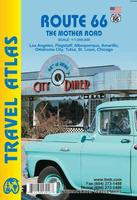
Route 66 Road Atlas. 1:1,000,000. ITMB.
The 'Mother Road' of the USA is one of the most famous highways of the world. When the highway was developed in the 1920s, America was just discovering the automobile and long-distance roads were visionary. Today, it has been replaced by the US Interstate system, but portions of the original highway remain, as well as many of its original buildings.
This atlas shows the route from its origins in Chicago, through Illinois and other states to California and its terminus in Santa Monica. The atlas shows the Route and has capsule comments about attractions; it includes parks, historic sites, and attractions within reasonable driving distances from Route 66. It covers the entire 2,400 miles of the Route and includes many detailed city plans of urban areas along the highway. 64 pages, printed on paper, saddle stitched. Center-stapled soft-cover atlas.
Sample detail of the Route 66 road atlas
$16.95
62-20973
Atlas.
Texas Road Maps - Paper Maps
Texas Road Map. Rand McNally.
This map has a state map on one side and on the reverse small city-center ms of Abilene, Amarillo, Austin, Beaumont, Big Bend National Park, Bryan/College Station, Corpus Christi, Dallas/Fort Worth & Vicinity, El Paso, Galveston, Houston & Vicinity, Laredo, Lower Rio Grande Valley, Lubbock, Midland/Odessa, and Port Arthur. Map size is 17 x 18 inches unfolded, ideal for using in a car.
$11.99
62-9590
Texas
Texas Road Map. Mapsco.
The Texas fold map is a full-color, regional map, including insets of: Abilene, Amarillo, Austin, Beaumont, Corpus Christi, Dallas, El Paso, Fort Worth, Gavleston, Houston, Laredo, Lubbock, San Antonio, Texarkana, and Waco; and features: Airports, detailed Parks and Places of Interest, Interstate Exit Numbers, Longitude and Latitude information, a Mileage Chart, and Parks and Rec Areas.
Texas and Oklahoma Travel Map. 1:1,300,000. ITMB, 2015.
Texas is the second largest State in the union (after Alaska), and is the only State to have previously been an independent country. It has one of the oldest urban areas in the US (Presidio); Big Bend National Park; Austin and its many festivals, and Gulf Coast beaches. Oklahoma's diverse landscape includes the Great Plains, mountains, lakes and forests. Oklahoma City, the capital, is home to the National Cowboy & Western Heritage Museum, recognizing the states pioneer history, and the Bricktown entertainment district, popular for dining and nightlife. The Red Earth Native American cultural festival is a major draw each June.
Front of the Texas and Oklahoma travel map. Reverse of the Texas and Oklahoma travel map.
$9.95
62-20913-TO
1 sheet, folded.
Texas Regional Road Maps. Mapsco.
These detailed maps cover a large portion of Texas.
$5.99
62-95908-CE
Texas Central Road Map. The Central Texas fold map is a full-color, regional map, including the Counties of: Anderson, Bell, Blanco, Bosque, Brazos, Brown, Burleson, Cherokee, Coleman, Concho, Coryell, Falls, Freestone, Gillespie, Grimes, Houston, Kimble, Lee, Limestone, Llano, Madison, Mason, McCulloch, McLennan, Menard, Milam, Mills, Robertson, San Saba, San Jacinto, Travis, Trinity, Walker, and Williamson.
$6.99
62-9592HILC
Texas Hill Country Road Map. The Hill Country, TX fold map is a full-color, regional map, including street-detail insets of: Bandera, Boerne, Burnet, Fredericksburg, Kerrville, Kyle, Marble Falls, New Braunfels, and San Marcos; and features: an Austin area map, Places of Interest, a San Antonio area map, and a Winery Index.
$7.99
62-95908-SO
Texas South Road Map. The South Texas fold map is a full-color, regional map, including the counties of: Aranssas, Atascosa, Bandera, Bee, Bexar, Brooks, Caldwell, Calhoun, Cameron, Comal, DeWitt, Duval, Frio, Goliad, Gonzales, Guadalupe, Hidalgo, Jim Hogg, Jim Wells, Karnes, Kenedy, Kleberg, LaSelle, Lavaca, Like Oak, McMullen, Medina, Nueces, Refugio, San Patricio, Starr, Victoria, Willacy, Wilson, and Zapata.
USA Southwest - Mexico Border & San Diego Travel Map. 1:1,390,000 & 1:10,000. ITMB.
The US side of the map extends north from San Diego all the way to Las Vegas eastward to Flagstaff, San Antonio, and Houston, showing tourist attractions across this vast area of America. The map also includes a detailed city-center map of San Diego.
Texas GuideMap Road Map - Waterproof Map. National Geographic Maps.
The front side is an easy-to-read road map with insets of: - Austin - San Antonio - Corpus Christi - Abilene - Waco - Laredo - Beaumont - McAllen - Odessa / Midland - El Paso - Lubbock - Amarillo The back includes: - Maps and information for Ft. Worth, Dallas, and Houston - Information for Big Bend National Park - Points of interest - Scenic drives - Park Service sites in Texas. Printed on waterproof, tear-resistant synthetic paper.
Sample detail from the Texas Guidemap Image of the front of the Texas Guidemap
$7.95
62-95903
1 sheet, folded
Texas Easy-to-Fold™ Road Map - Laminated Map. Rand McNally.
The durable and convenient Texas Easy-To-Fold state map will take all the wear and tear your journey can dish out. The heavy-duty laminated design allows you to mark your route, make notes, then wipe the surface clean for further use. Map size is 18 x 17 inches unfolded, ideal for using in a car. Laminated.
$9.99
62-95901
1 sheet, folded.
Texas Road Map - Laminated Map. Mapsco.
This map of Texas is durably laminated and contains extensive coverage. Laminated maps are easy to fold, write on, and wipe off. Coverage includes insets of: Abilene, Austin, Corpus Christi, Dallas, El Paso, Fort Worth, Houston, San Antonio, and Texarkana; and features: Interstate Exit Numbers, Latitude and Longitude information, Parks and Rec Areas, and Places of Interest. Size is 18 x 27" unfolded. Laminated.
$9.99
62-95909
1 sheet, folded, laminated.
Texas City Maps - Paper Maps
Texas Pocket-Sized Paper City Maps
Dallas PopOut Pocket Map. PopOut.
Featuring a central and greater crop of the city, plus smaller maps of popular tourist areas and a transportation map to navigate the city, the PopOut has everything you need to discover Dallas.
$6.95
62-9592DF
1 sheet, folded
San Antonio PopOut Pocket Map. PopOut.
Featuring a central and greater crop of the city, plus smaller maps of popular tourist areas and a transportation map to navigate the city, the PopOut has everything you need to discover San Antonio.
$6.95
62-9592SD
1 sheet, folded
Texas Full-Sized Paper City Maps
Texas Paper City Maps. Various publishers, including Mapsco, Rand McNally, Universal Maps, and others. These are standard folded street maps showing excellent detail of the specific area. When unfolded they are typically 28 x 40 inches or slightly smaller.
$4.95
62-9592ABIL
Abilene Street Map. (Five Star).
$5.99
62-9592AM
Amarillo Street Map. (Rand McNally).
Arlington & Grand Prairie Street Map. See Fort Worth-Arlington below.
$6.99
62-9592AU
Austin, Georgetown, and Round Rock Street Map. (Rand McNally).
$7.99
62-9592AUS
Austin Street Map. (Mapsco).
$4.95
62-9592BAY
Baytown, La Porte, Pasadena Street Map. (Seeger).
$4.95
62-9592BE
Beaumont & Port Arthur Street Map. (Rand McNally).
$4.95
62-9592BT
Bryan and College Station Street Map. (Rand McNally).
$4.95
62-9592CE
Cedar Hill/DeSoto/Duncanville Street Map. (Mapsco).
$7.99
62-9592COR
Corpus Christi Street Map. (Mapsco).
$6.99
62-9592DB
Dallas Street Map. (Rand McNally).
$6.99
62-9592DAL
Dallas Street Map. (Mapsco).
$5.99
62-9592DFT
Dallas & Ft. Worth Street Map. (Rand McNally).
$7.99
62-9592DFW
Dallas & Fort Worth Metroplex Street Map. (Mapsco).
Denton - see 62-9592PLA Plano, Denton, Lewsiville, McKinney city map below. Dallas's northern suburbs. (GM Johnson).
$5.99
62-9592E
El Paso Street Map. (Rand McNally).
$5.99
62-9592ELP
El Paso Street Map. (Mapsco).
$6.95
62-9592FW
Fort Worth and Arlington street map. (GM Johnson). Also covers Bedford, Euless, Forest Hill, Haltom City, River Oaks, and adjoinging communities.
$7.99
62-9592FOR
Fort Worth Street Map. (Mapsco).
$6.99
62-9592F
Fort Worth Street Map. (Rand McNally).
$5.99
62-9592GD
Garland, Richardson, McKinney, Mesquite Street Map. (Universal).
$5.99
62-9592HI
Hill Country Street Map. (Rand McNally).
$7.99
62-9592H
Houston Street Map. (Mapsco).
$5.99
62-9592HO
Houston Street Map. (Rand McNally).
$6.99
62-9592HOS
Houston - South & Southwest Suburbs Street Map. (Mapsco).
$5.99
62-9592TW
Houston - Northern Suburbs & The Woodlands Street Map. (Rand McNally).
$6.99
62-9592HOV
Houston & Vicinity Highways Map. (Rand McNally).
$5.99
62-9592KL
Killene & Ft. Hood Street Map. (Mapsco).
$5.99
62-9592LA
Lake Travis Street Map. (Mapsco).
$5.99
62-9592LC
Laredo, McAllen, Brownsville Street Map. (Rand McNally).
$7.99
62-9592MI
Midland/Odessa Street Map. (Mapsco).
$5.95
62-9592PLA
Plano, Denton, Lewsiville, McKinney city map. Dallas's northern suburbs. (GM Johnson).
$5.99
62-9592SAN
San Antonio Street Map. (Mapsco).
$6.99
62-9592SB
San Antonio Street Map. (Rand McNally).
$5.99
62-9592TE
Texarkana Street Map. Also covers Nacogdoches and Lufkin Texas. (Seeger).
$4.95
62-9592WIC
Wichita Falls Street Map. (Mapsco). Out of print when sold out.
Texas City Maps - Laminated Maps
Dallas StreetSmart® Laminated Map. VanDam.
VanDam's best selling Dallas StreetSmart maps all Dallas attractions, neighborhoods, museums, hotels and more at an immensely legible scale with 3D buildings. Includes details of Downtown Dallas, Fair Park and Cotton Bowl. This sexy laminated city map package refolds easily to 4" x 9" (24" x 9" open) and snuggly fits into your pocket.
Sample detail from the Dallas StreetSmart map
$7.95
62-95921DA
1 sheet, folded
Dallas MapEast Waterproof Map. MapEasy.
MapEasy will show you where to eat ...whether you are looking for a true Tex-Mex meal or innovative southwest cuisine... and where to party in the hip old jazz district of Deep Ellum. The Dallas Guidemap includes detailed sections for Dallas Market District, Uptown, Deep Ellum, Highland Park and Fair Park.
Sample detail from the San Antonio StreetSmart map
$7.95
62-9592DE
1 sheet, folded
Houston StreetSmart® Laminated Map. VanDam.
VanDam's best selling Houston StreetSmart maps all of Houstons's attractions, neighborhoods, museums, hotels and more at an immensely legible scale with 3D buildings. Includes details of Downtown and Museum District. This sexy laminated city map package refolds easily to 4" x 9" (32" x 9" open) and snuggly fits into your pocket.
Sample detail from the Houston StreetSmart map
$7.95
62-95921HO
1 sheet, folded
San Antonio StreetSmart® Laminated Map. VanDam.
VanDam's best selling San Antonio StreetSmart maps all of San Antonio's attractions, neighborhoods, museums, hotels and more at an immensely legible scale with 3D buildings. This sexy laminated city map package refolds easily to 4" x 9" (24" x 9" open) and snuggly fits into your pocket.
Sample detail from the San Antonio StreetSmart map
$7.95
62-95921SA
1 sheet, folded
Full-size Texas Laminated City Maps. Mapsco and Rand McNally. These folded and laminated maps are typically larger - 18 x 20" or so and fit in a hip pocket, but not a shirt pocket.
$7.95
62-9592DG
Dallas & Ft. Worth Highways Easy-to-Fold Laminated Map. (Rand McNally).
El Paso Streetfinder Atlas. Spiral-bound atlas. (Rand McNally).
$18.99
62-95922ELP
El Paso Street Atlas. (Mapsco).
$39.99
62-95922FO
Fort Worth Street Atlas. (Mapsco).
$24.95
62-95922FW
Fort Worth Street Atlas. (Rand McNally).
$8.99
62-95922RI
Rio Grande Valley Street Atlas. (Mapsco).
$39.99
62-95922SA
San Antonio Street Guide Atlas. (Mapsco).
$26.95
62-9592SS
San Antonio Streetfinder Atlas. (Rand McNally).
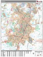
Texas City, County, and State Business Wall Maps
Texas City Wall Maps.
When it comes to general planning, defining delivery areas, planning direct marketing and delivering products, our city wall maps are perfect to get the detailed information you need.
These maps offer clear mapping by showing all major streets and roads, but leaving out the smaller streets.
If you want a clear map for easy planning, then these are the maps for you; if you want a map showing every little back alley, these are not for you.
We offer wall maps for Abilene, Allen, Amarillo, Arlington, Austin, Baytown, Beaumont, Brownsville, Bryan, Carrollton, Cedar Park, College Station, Conroe, Corpus Christi, Dallas, Dallas-Fort Worth, Denton,
DeSoto, Edinburg, El Paso, Euless, Flower Mound, Fort Worth, Frisco, Galveston, Garland, Georgetown, Grand Prairie, Grapevine, Harlingen, Houston, Irving, Killeen, Laredo, League City, Lewisville, Longview,
Lubbock, Mansfield, McAllen, McKinney, Mesquite, Midland, Mission, Missouri City, New Braunfels, North Richland Hills, Odessa, Pasadena, Pearland, Pflugerville, Pharr, Plano, Port Arthur,
Richardson, Round Rock, Rowlett, San Angelo, San Antonio, San Marcos, Sugar Land, Temple, Tyler, Victoria, Waco, and Wichita Falls.
We offer state and county wall maps for all of the USA. The maps come in sizes from 24 x 36 to 108 x 144 inches. They are available in variety of mounting and framing options. The maps are ideal for business applications, sales territory, delivery planning, direct mail targeting and hundreds of other applications.
Click here for 1:250,000 sectional raised relief maps.
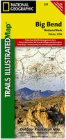
Waterproof Big Bend national Park hiking map. 1:27,500 & 1:133,333. National Geographic Maps/Trails Illustrated.
The map includes Big Bend National Park, Portions of Big Bend Ranch State Park, Black Gap Wildlife Management ARea, the Chisos Mountains, Sierra del Carmen, Sierra del Caballo Muerto, designated backcountry camping sites, park information, and more. Includes UTM tick marks for use with your GPS unit. Map size is 26 x 38 inches unfolded.
Big Bend N.P. map coverage Thumbnail of the front of the Big Bend map. Detail from the Big Bend map.
The Lone Star Hiking Trail Guidebook. Wilderness Press.
One of the hidden jewels of Texas, the Lone Star Hiking Trail is the only long-distance National Recreation Trail in the state. At 128 miles (including loop trails), it is also the states longest continuously marked and maintained footpath. The trail meanders through flat and gently rolling forests of pine, oak, and mixed hardwood, and cypress swamps and bayous in the famed Big Thicket area in east Texas, in the Sam Houston National Forest. The seemingly endless variation of forests, much of it designated wilderness, provides a paradise for tree-lovers and bird watchers year-round. The trail is well-suited for both short and long hikes (of up to 10 days), appealing to dayhikers, overnight backpackers, long-distance hikers, and others seeking a peaceful outing.
The first guidebook to this trail; officially endorsed and promoted by the Lone Star Hiking Trail Club. Includes detailed topographic maps and GPS waypoints.
$17.95
62-9595LO
Guide.
Texas Wall Maps
Texas State and County Wall Maps. Intelligent Direct.
We offer state and county wall maps for all of the USA. The maps come in sizes from 24 x 36 to 108 x 144 inches. They are available in variety of mounting and framing options. The maps are ideal for business applications, sales territory, delivery planning, direct mail targeting and hundreds of other applications.
Click here to order county wall maps and to see sample images, descriptions, and prices.
Click here to order state wall maps and to see sample images, descriptions, and prices.
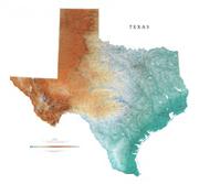
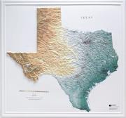
Texas Shaded Relief Wall Map. 1:1,100,000. Raven Maps.
The Lone Star State may be known for bluebonnets, pecans, and armadillos, but the scope of its geographic variety is stunningly apparent on this map of Texas. The Great Plains and the southern part of the Rocky Mountains spread through the Panhandle, and in the south, the Gulf Coast Plain runs into the Gulf of Mexico. Elevations are represented by color, and this, in combination with our relief shading technique, gives the map a 3-dimensional look. Size is 45 x 50".
Thumbnail of the map. Sample of the detail.
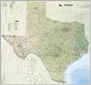
Texas wall map. National Geographic Maps.
National Geographic proudly presents our new Texas State Wall Map, part of our growing series of State Wall Maps. Ideal for home or business, Texas is printed on a premium print quality stock ideal for framing or is also available in a durable laminated edition. Size is 41 x 31 inches.
Sample detail from the Texas wall map Image of the Texas wall map
$24.99
62-9549
1 sheet, flat.
$39.99
62-9549L
Laminated.
Texas antique-style wall map - style #1. 23 x 23".
With an area of 268,000 square miles and a population of more than 19 million, Texas is the second largest state in both size and population. Stretching 800 miles from Louisiana to New Mexico, Texas was ruled by Spain and Mexico before becoming an independent nation in 1836. It joined the Union in 1845. Texas boasts a divers economy that includes oil, manufacturing, high tech and agriculture. Its largest cities are Houston and Dallas with the state capital being Austin.
$6.95
62-9546M
Mouse pad. 7-1/2" x 9".
$30.00
62-9546
1 sheet, rolled.
$275.00
62-9546D
Deluxe frame
$224.99
62-9546S
Standard frame
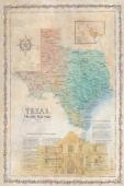
Texas Antique-style wall map - style #2. With an area of 268,000 square miles and a population of more than 19 million, Texas is the second largest state in both size and population. Stretching 800 miles from Louisiana to New Mexico, Texas was ruled by Spain and Mexico before becoming an independent nation in 1836. It joined the Union in 1845. Texas boasts a divers economy that includes oil, manufacturing, high tech and agriculture. Its largest cities are Houston and Dallas with the state capital being Austin.
$40.00
62-95461
1 sheet, flat.
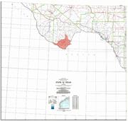
Texas Base Map. 1:1,000,000. USGS, 1982. Four sheets combine to give complete coverage of Texas. The base map shows roads, towns, rivers/hydrology, but lacks contours.
Thumbnail of the Texas base map.
$39.95
62-95502
4 sheets, flat.
A great gift for the shark enthusiast! Shark Attack Poster of the Atlantic Ocean and the Gulf of Mexico. Sealake Products. This fascinating, educational print shows the locations of over 300 shark attacks in the Atlantic and Gulf of Mexico from 1905 to the present. 35 hair-raising encounters
are detailed, including the 1916 attacks in New Jersey. Plus, you'll learn interesting facts about the 12 types of sharks blamed for the attacks. Also, an actual size tooth from each of the three most dangerous sharks is shown. Size is 24 x 36". Available rolled/flat, either as plain paper or laminated.


 Sample detail of the Route 66 road atlas
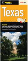
 Sample detail from the Texas road map.
 Front of the Texas road map.
 Reverse of the Texas road map.
 Front of the Texas and Oklahoma travel map.
 Reverse of the Texas and Oklahoma travel map.
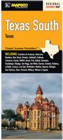

 Sample detail #1 of the USA - Mexico Border Travel Map
 Sample detail #2 of the USA - Mexico Border Travel Map
 Sample detail from the Texas Guidemap
 Image of the front of the Texas Guidemap
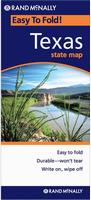


 Sample detail from the Dallas StreetSmart map
 Sample detail from the San Antonio StreetSmart map
 Sample detail from the Houston StreetSmart map
 Sample detail from the San Antonio StreetSmart map
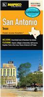

 Sample detail from the Austin wall map.
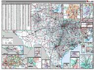 Texas County and State Wall Maps.

 Texas Raised Relief Maps.
 Waterproof
 Big Bend N.P. map coverage
 Thumbnail of the front of the Big Bend map.
 Detail from the Big Bend map.
 Waterproof
 Thumbnail of the front of the map.
 Thumbnail of the reverse of the map
 Detail from the map.

 Thumbnail of the map.
 Sample of the detail.
 Sample detail from the Texas wall map
 Image of the Texas wall map
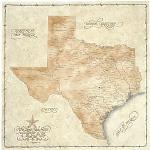


 Texas Base Map. 1:1,000,000. USGS, 1982. Four sheets combine to give complete coverage of Texas. The base map shows roads, towns, rivers/hydrology, but lacks contours.
 Thumbnail of the Texas base map.
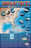 A great gift for the shark enthusiast!
 Image of the entire poster
 Sample of the map detail, covering Florida.
 Sample of the Great White Shark text.
 Sample of the text describing the attacks.
 Texas Flags