3-sheet map set covers more than 1,200 rail attractions across the entire countrythe most comprehensive and up-to-date listing anywhere!
Locations are shown on detailed maps for easy travel planning. Text includes descriptions, physical locations, contact info and symbols for 8 categories of attractions.
Locations shown on detailed mapsincluding 7 insetsfor easy travel planning. GPS addresses in directory.
Each map has 16 eye-catching, original watercolor illustrations.
$24.95
62-20983S
3 sheet set, folded.
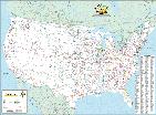
Railroads of the Continental United States. Deskmap Systems. This map is the industry standard railroad map and is currently used by thousands of transportation professionals. The complete US rail system as well as southern Canada and northern Mexico are displayed on this 36" x 48" map. Printed in full colors, the highly detailed map shows more than 7,000 cities, towns, and station points.
Reporting marks on the map are indexed for more than 650 railroad companies to identify operations. Intermodal hubs and interchange points are clearly represented. Available only as laminated flat (rolled) map. Size is 36 x 48"
$69.99
62-20905L
1 sheet, laminated.
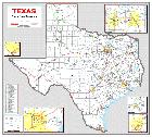
Texas Railroad Systems Map. DeskMap Systems, Inc. This 36" x 39" Texas Railroad Systems Map shows all rail lines in Texas. The full-color map has five insets showing rail detail of Dallas-Ft. Worth, Houston, Beaumont, El Paso, and San Antonio. The map displays interstate and major highways, counties and water detail. 36 x 39".
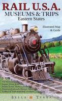
 Front of the Eastern USA Railroad Map
 Reverse of the Eastern USA Railroad Map
 Sample detail of the Eastern USA Railroad Map
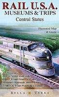
 Front of the Central USA Railroad Map
 Reverse of the Central USA Railroad Map
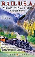
 Front of the Western USA Railroad Map
 Reverse of the Western USA Railroad Map
 Sample detail of the Western USA Railroad Map