World Maps for Kids. Maps include political maps, physical maps, maps with animals, world upside-down maps, equal-area maps, and more.
World Maps for Kids. By Rand McNally.
USA Maps for Kids. Maps include political maps, physical maps, maps with animals, and more.
3D Postcards. Watch the globes turn as you move the card!
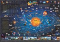
Solar System Maps For Children
Children's Map of the Solar System. Dino's.
This children's map of the solar system is generously illustrated with cartoon images of planets, comets, stars, spaceships, and many other features. The images are cross referenced to a listing of facts, and encourage interaction with children to further their knowledge of the universe. Children and those young at heart will be entertained for hours by this fascinating map! Size is 38 x 54".
Sample detail from the Solar System Map Image of the entire Solar System Map
$13.99
67-7349
1 sheet, rolled.
USA Maps For Children
Children's Map of the USA. Dino's.
This colorful informative United States map is made especially for children. Heavily illustrated with fun pictures and descriptive text, this map can keep children entertained for hours. The illustrations depict where mountain ranges, deserts, seas, etc. are located and what types of animals can be found in each region of the USA. Not only is this map fun, but it is educational as well. It makes the perfect addition to any classroom, children's bedroom, or playroom. Adults will also enjoy the fun nature of this one-of-a-kind map of the United States. Map size is approximately 54" W x 38" H.
Image of the entire map Sample detail of the map
$17.99
62-1994
1 sheet, rolled.
Signature U.S.A. Political Map. Rand McNally.
Wake up your walls with Rand McNally's colorful, contemporary U.S. Wall Map. A combination of bold colors and detailed cartography makes this map stand out in any home, classroom, or office.
State capitals, national parks, and time zones clearly marked
Color-matching relief shows mountain ranged and other elevation changes
Classic U.S.A. Political Map. Rand McNally.
Parchment-like paper and rich, subdued colors give this map a sophisticated old-world style while delivering the digital accuracy and extraordinary clarity you'd expect from any Rand McNally map. Size is 50 x 32".
Thumbnail of the Rand McNally USA map
$12.99
62-19481
1 sheet, flat/rolled
$19.99
62-19481L
Laminated.
World Maps For Children
Children's Map of the Prehistoric World. Dino's. Dino's all new Illustrated Map of the Prehistoric World includes hundreds of historical, educational, and entertaining points of interest illustrations amazingly drawn by skilled artists combining detailed information and creativity results in one of the most uniquely entertaining maps available. Protected by durable lamination. Map size is approximately 54" x 38."
Sample of the map detail Image of the entire map
$19.99
67-5801
1 sheet, rolled.
Children's World Map. Dino's.
Illustrated with flags of the world and 450 fun facts. It shows all the continents with illustrations of their natural resources and national costumes. How did people discover far off lands with their indiginous flaura and fauna? Take a look - its a most entertaining and well thought out childrens map, looks good with a flat bright background and the countries, birds animals etc., all UV varnished to stand out and look attractive. This children's map of the world is the most interesting and eye-catching map we have ever seen. Your kids will spend hours looking and studying all the graphics on this map. What's more, they will accidentally learn world geography in the process.
This world map is "off the hook" when it comes to awesome graphics. It is perfect for a teenager's room. Be sure to take a look at the close-up to see the detailed pictures used on this map. They are intended to represent the primary activities in that part of the world. The Childrens World Map comes standard with a heavy varnish coating on the front. This coating will allow you to clean the map with a wet paper towel.
Image of the entire map Sample of the map detail
$14.99
67-5802
1 sheet, rolled.
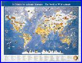
Children's World Map of Animals. Dino's.
This colorful, informative Dinos Animals of the World poster wall map is made especially for children. Illustrated with cartoonish pictures and descriptive text, this map can keep children entertained for hours. The illustrations depict where mountain ranges, deserts, and seas are located and what types of animals can be found in each region of the world. It makes the perfect addition to any classroom, children's bedroom, or playroom. Adults will also enjoy the fun nature of this one-of-a-kind map of the world.
Measures 54" wide x 38" high and the durable laminated surface is markable with a water based pen.
Sample of the World of Animals map detail Image of the entire World of Animals map
$14.99
67-5804
1 sheet, rolled.
Children's Map of the Ancient World. Dino's.
The Dino's Illustrated Map of the Ancient World is an incredible map for children loaded with illustrations of ancient lost worlds and historical interests. This map is laminated and measures 38"x54".
Sample detail of the Ancient World map Image of the Ancient World map
$14.99
67-5807
1 sheet, rolled.
World Signature Political Map. Rand McNally.
This eye-catching wall map's combination of bold colors and detailed cartography make it a handy reference piece that's sure to stand out in any home, classroom, or office.
Map centered on Africa allowing viewers to see continents complete and intact
Clearly labeled country and city names for easy viewing
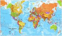
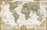
Classic World Political Map. Rand McNally.
Parchment-like paper and rich, subdued colors give this map a sophisticated old-world style while delivering the digital accuracy and extraordinary clarity you'd expect from any Rand McNally map. Size is 50 x 32".
Thumbnail of the Rand McNally World map
$12.99
67-10496
1 sheet, flat/rolled
$19.99
67-10496L
Laminated
Children's World Map. Michelin, 2014.
Michelin's beautifully colored and engaging laminated world wall map is designed to capture children's interest and lead them to interact with the map and its reusable flag stickers. In the process children discover world geography and learn to identify countries in an enjoyable yet informative way. A child chooses a flag from the sticker sheet, locates the associated country with the help of the map's flag border, and places the flag on the proper country on the map. The laminated wall map serves as a constant visual reference, illustrating the different countries of the world.
Thumbnail of the Children's World Map.
$12.95
67-5819
1 sheet, rolled.
Kids Map of the World. 1:45,000,000. National Geographic Maps.
National Geographic's The World for Kids wall map is an enticing and engaging world map perfect for classroom, home or library. Recommended by geography educators for ages 7 - 12, this map features an optimized map design for readability and easy, intuitive learning. All 195 independent countries and their official, colorful flags are represented and arranged in alphabetical order for ease-of-use. Expertly researched, The World for Kids map is an essential reference tool for today's interesting geographical world. All proceeds from the purchase of a National Geographic map help support the Society's vital exploration, conservation, scientific research, and education programs.
Sample detail from the Kids world map Thumbnail image of the entire Kids world map
$16.99
67-5810
1 sheet, rolled, in a gift box.
$24.99
67-5810L
Laminated.
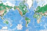
World Physical Map. 1:30,000,000. DMA/NIMA/USGS.
An attractive large-sized world physical map that is reasonably up-to-date (lacking only the Zaire to Democratic Republic of Congo change). This is the updated single-sheet version of the 8-sheet World Wall Mural map (67-8805).
Updated 3-sheet and 6-sheet versions are also available. These maps are all made from the same original cartographic image, so the detail is the same on each map, just enlarged more for the larger wall maps. Please note that we have put sample images up for each size. Each sample is scanned at 1:1 and covers the same area of the map; the SE USA. This way you can see the comparable size and detail of the maps. Mercator projection.
8 sheets, rolled. Size 8.5 x 13.5 feet. Printed on wall paper for easy application.
$249.99
67-88051
8 sheets, rolled. Size 8.5 x 13.5 feet. "Executive" version with special coating to allow writing on the map with watersoluble markers. Printed on wall paper for easy application.
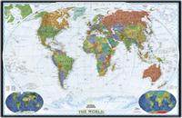
World Wall Maps by National Geographic
Our favorite two world maps
World Maps - Decorator style.
Colorful and bold - countries easily identified. Enjoy the accuracy and beauty of the latest world map from the cartographers at National Geographic. This map features the Winkel Tripel projection. The Decorator map has spectacular color and detail to bring the world alive. Ideal for home, office, or school.
Thumbnail of the entire map Sample map detail #1 Sample map detail #2 An enlarged view of the mounted map
Small Size - paper and/or laminated
$16.99
67-10536
World Political Map, Winkel projection. 1:38,931,000. 46 x 30".
$29.95
67-10536L
World Political Map, laminated.
Large Size - paper and/or laminated
$34.99
67-10537
World Political Map, Winkel projection - large size. 1:24,000,000. 73 x 48".
Current information with an old look. Enjoy the accuracy and beauty of the latest world map from the cartographers at National Geographic. This map features the Winkel Tripel projection and has elegant, rich tones that will complement any office or home. Astounding detail and board room quality make these maps excellent for reference or as a keepsake for your map library. This is a current political map featuring an antique style. 43'' x 30''.
Winner of the 2001 Premier Print Award from Printing Industries of America for "a unique ability to create visual masterpieces"
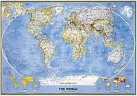
Classic National Geographic World Map! World Political Map. This famous map features the Robinson projection, which minimizes distortion relative to shapes, distances and perspective. Insets of physical hemispheres, polar views, vegetation and land use, and population density. Available in three sizes.
Small size - 43-1/2" x 30-1/4". Huge size - 71-1/4" x 50". Mural size - 110" x 76" (9' 2" x 6' 4"). An image of the full map A detail of the map A sample of the legend An enlarged view of the mounted map
Small Size - paper and laminated
$14.99
67-10530
Small size - 43-1/2" x 30-1/4". Rolled.
$24.99
67-10530L
Small size - laminated.
Large Size - paper and laminated
$34.99
67-10531
Large size - 71-1/4" x 50".
$59.99
67-10531L
Large size - laminated.
Wall Mural Size - wall paper
$99.99
67-10532
Mural size - 110" x 76" (9' 2" x 6' 4"). 1:15,267,000. This supersized panorama comes boxed in three sections and hangs like wallpaper. Printed on latex-coated paper stock.
Indians of North America. An illustrated ethnological map, color-coded to show native locations of different tribes. Size is 33" x 38".
Thumbnail view of the front of the map.
$19.99
62-19452
Flat/rolled
$25.95
62-19452L
Laminated.
North America in the Age of Dinosaurs. 1994. Looking for a different map of North America? Try the Mesozoic era! Locations of dinosaur fossil discoveries, beautiful illustrations, and adescriptions of the dinosaurs themselves. Size is 22-1/4" x 30-1/2".
An image of the full map A detail of the map
World Wall Mural, normal style. 8 sheets, rolled. Size 8.5 x 13.5 feet. This map is a "repeating" map, so you can Europe/Africa or North/South America or Asia/Pacific in the center of the map.
$249.99
67-88051
Executive write-on & erase style. 8 sheets, rolled. Size 8.5 x 13.5 feet. "Executive" version with special coating to allow writing on the map with watersoluble markers.
Saturn & Three Moons wall mural. Size is 13'8" x 8'3".
$139.95
67-8815
8 sheets, rolled. Size 8.5 x 13.5 feet.
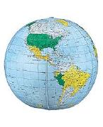
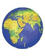
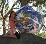
Inflatable Globes
Inflatable Globes. Great for a gift! These inflatable globes show political boundaries and the constellations of the night sky. Fun, and educational too!
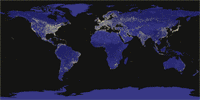
39" & 16" Inflatable EarthBall. EarthBall inflatable globes are the most realistic Earth replicas ever made. EarthBalls feature glow in the dark cities and interesting cloud formations as captured by thousands of NASA satellite images of Earth. The continents are not distorted; they are truly depicted as an astronaut would see Earth from space.
EarthBalls offer an important global perspective, our world without boundaries. The 16" diameter inflatable globe makes a terrific gift. Available in 16" diameter and 1 meter (39") diameter sizes.
Overall view of the 1 meter globe. Overall view of the 16" globe. View #2 of the 16" globe Enlarged view of the 16" globe.
$15.99
68-1600
16" Earthball.
$129.99
68-1601
1 meter Earthball.
Clear Ocean Inflatable Globes
$6.99
68-1612
12" clear ocean globe
$11.99
68-1615
16" clear ocean globe
$19.95
68-1622
27" clear ocean globe
Blue Ocean Inflatable Globes
$7.49
68-1610
12" blue ocean globe
$9.99
68-1616
16" blue ocean globe
$25.99
68-1620
27" blue ocean globe
Dark Blue Ocean/Physical Inflatable Globes
$7.49
68-1613
12" physical globe
$9.99
68-1617
16" physical globe
$27.99
68-1624
27" physical globe
3D Postcards
See the borderline between reality and picture disappear, as you watch the globe turning inside your hands, seemingly within easy reach.
A fascinating effect on a perfectly flat display: This postcard is just 1 millimetre thin, thanks to the patented True-3D technology.
A great keepsake, and an impressive greeting card as well (standard postage).
This postcard is not an embossed map - it is perfectly flat - you cannot feel the shape of the relief. The three-dimensional impression is solely achieved by means of a special printing process. Thus you do not need the otherwise usual red-green glasses, either.
 Sample detail from the Solar System Map
 Image of the entire Solar System Map
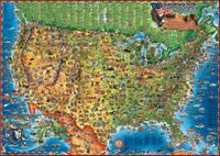
 Image of the entire map
 Sample detail of the map
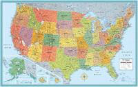
 Thumbnail of the Rand McNally USA map
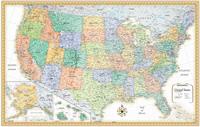
 Thumbnail of the Rand McNally USA map
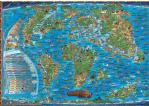
 Sample of the map detail
 Image of the entire map
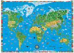
 Image of the entire map
 Sample of the map detail
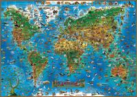
 Sample of the World of Animals map detail
 Image of the entire World of Animals map
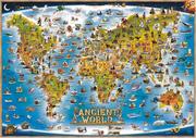
 Sample detail of the Ancient World map
 Image of the Ancient World map
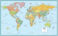
 Sample detail of the Rand McNally World map
 Thumbnail of the Rand McNally World map
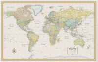
 Thumbnail of the Rand McNally World map
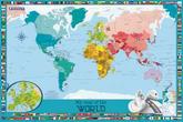
 Thumbnail of the Children's World Map.
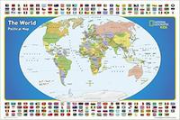
 Sample detail from the Kids world map
 Thumbnail image of the entire Kids world map
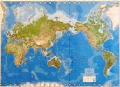
 World Physical map, full view.
 Image of Wall Mural map after mounting on wall.


 Thumbnail of the entire map
 Sample map detail #1
 Sample map detail #2
 An enlarged view of the mounted map


 An image of the full map
 A detail of the map
 A sample of the legend

 Thumbnail view of the front of the map.
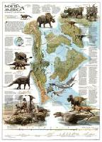
 An image of the full map
 A detail of the map
 Overall view of the 1 meter globe.
 Overall view of the 16" globe.
 View #2 of the 16" globe
 Enlarged view of the 16" globe.