France Historical Battlefield & Historical Provincial Maps
WWI Trench maps for Belgium & France. 1:10,000/1:20,000. G.H. Smith. A series of British Army trench maps from the WWI, reproduced at approximately 7/10th size. The maps show both the British and the enemy trenches. Several of the maps also indicate supply and ammunition dumps, machine gun and trench mortar emplacements, observation posts, etc. The maps have a bilingual legend for terms found on the map.
64-1969-02
Arras - 51B-NW-3. 1:10,000. Trench data as12/27/1916.
$12.99
64-1969-03
Beaumont - 57D-SE-1&2. 1:10,000. Attack map for July 1st, 1916. 36th Ulster Division, General Nugent.
$12.99
64-1969-17
Beaumont - 57D SE2. 1:10,000. Trench data as 2/17/1917. Partially overlaps with 64-1969-03 below.
$12.99
64-1969-01
Belgium (Ypres) - #28 NW. 1:20,000. Trench data as of 1/4/1917.
$12.99
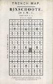
64-1969-04
Bixschoote - 20-SW-4. 1:10,000. Trenches correct as of 6/13/1917.
$12.99
64-1969-18
Fonquevillers - 57D NE 1&2. 1:10,000. Trench data as 1/16/1916.
$12.99
64-1969-19
France (Albert) - 57C SW. 1:20,000. Trench data as 3/9/1916.
$12.99
64-1969-26
France (Gommecourt) - 57D NE. 1:20,000. Trench data as 16/5/1916.
$12.99
64-1969-05
Gheluvelt - 28-NE-3. 1:10,000. Trenches correct as of 1/4/1917.
$12.99
64-1969-06
Hebuterne - 57D-NE-3/4. 1:10,000. Trench data as of 2/23/1916.
$12.99
64-1969-07
Honnecourt - 57B-SW-3. 1:10,000. Trench data as of 5/19/1917.
$12.99
64-1969-08
Houplines - 36-NW-2 & 36-NE-1 (parts of both). 1:10,000. Trench data as of 9/23/1917.
$12.99
64-1969-30
Laventie - 36 SW-1. 1:10,000. Trench data as 7/21/1915.
$12.99
64-1969-20
Longueval - 57C SW-3. 1:10,000. Trench data as 8/15/1916.
$12.99
64-1969-09
Lens - 36C-SW-1. 1:10,000. Trench data as of 6/26/1917.
$12.99
64-1969-31
Loos - 36C NW, Edition 3. 1:10,000. Trench data as 7/26/1915. Covers same area as 64-1969- Loos below but on different dates.
$12.99
64-1969-24
Loos - 36C NW-3 & part of 1, provisional edition. 1:10,000. Trench data as 8/25/1915.
$12.99
64-1969-27
Maricourt - 62C NW-1. 1:10,000. Trench data as 9/6/1916.
$12.99
64-1969-21
Meaulte - 62D NE-2. 1:10,000. Trench data as 4/25/1916.
$12.99
64-1969-10
Messine - 28-SW-2&4 (parts). 1:10,000. Trench data as of 9/4/1916.
$12.99
64-1969-16
Nieuport - 12 SW-1. 1:10,000. Trench data as 7/25/1917.
$12.99
64-1969-28
Ovillers - 57D SE-4. 1:10,000. Trench data as 4/27/1916.
$12.99
64-1969-11
Ploegsteert - 28-SW-4. 1:10,000. Trenches correct as of 1/4/1917. This map is a geologic/topo map showing how the geology limits location of the trenches (no soil strength).
$12.99
64-1969-22
Quéant- 57C NE-1. 1:10,000. Trench data as 7/6/1917.
$12.99
64-1969-12
Roclincourt - 51B-NW-1. 1:10,000. Trench data as 12/27/1916.
$12.99
64-1969-32
St. Julien - 28 NW-2. 1:10,000. Trench data as 6/30/1917.
$12.99
64-1969-13
Thiepval Wood - 57B-SE-2/4 (parts). 1:10,000. Royal Engineers hand-drawn and annotated map from 1/7/1916.
$12.99
64-1969-29
Vimy - 44A SW-3. 1:10,000. Trench data as 5/8/1918.
$12.99
64-1969-14
Wytschaete - 28 SW-2. 1:10,000. Trenches correct as of 1/4/1917.
$12.99
64-1969-15
Zillebeke - 28 NW-4 & 28-NE-3 (parts). 1:10,000. Trench data as of 6/30/1917.
$12.99
64-1969-25
Zonnebeke - 28 NE-1. 1:10,000. Trench data as 12/5/1917.
$12.99
WWII Air Photos from D-Day landings.
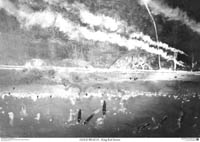
Global Mapping UK. These photos are printed from scanned original aerial photographs in various British museums and libraries. These photos show the beaches and the near-shore areas during the period June 6 to October 2, 1944. Printed are quality glossy photo-paper, these prints clearly show ships, landing craft, vehicles and less clearly, soldiers. Note that the actual prints are far superior to the images shown here, which are low-resolution images for quick viewing. Shipped rolled in a tube, each print measures approximately 23 x 33". Available either as glossy paper print, or as a laminated glossy print.
Gold Beach, King Red Sector. June 6th, 1944, (time unkown), west of La Rivière at King Red Sector. This aerial photograph shows the effects of the pre-invasion bombardment on King Red, and the initial landing of British troops.
Thumbnail of the entire poster
64-5638-KR
Paper
$12.95
64-5638-KRL
Laminated.
$24.95
Gold Beach. June 6th, 1944, (time unkown) West of La Rivière at King Red Sector. This aerial photograph shows large numbers of British troops landing on Gold Beach.
Thumbnail of the entire poster
64-5638-GO
Paper
$12.95
64-5638-GOL
Laminated.
$24.95
Gold Beach Panorama. June 6th, 1944, (time unkown). Taken from a higher altitude, this air photo offers a panoramic view of Gold Beach landing area.
Thumbnail of the entire poster
64-5638-GP
Paper
$12.95
64-5638-GPL
Laminated.
$24.95
Juno Beach. June 6th, 1944, (time unkown). This aerial photograph shows British and Canadian troops landing on Juno Beach and beginning their breakout past the port of Courseilles -sur-Mer..
Thumbnail of the entire poster
64-5638-JU
Paper
$12.95
64-5638-JUL
Laminated.
$24.95
Mulberry Harbour. October 2nd, 1944, (No time recorded) Arromanches. Oblique aerial photograph of the British Mulberry Harbour. Constructed of concrete caissons and pontoons, the harbours made the whole Normandy campaign subsequent to the D-Day landings possible.
Thumbnail of the entire poster
64-5638-MU
Paper
$12.95
64-5638-MUL
Laminated.
$24.95
American Troops landing on Omaha Beach. June 6th, 1944, 12:15, Les Moulin's between Dog Red and Easy Green Sectors. This aerial photograph shows American troops landing on Omaha Beach.
Thumbnail of the entire poster
64-5638-OM
Paper
$12.95
64-5638-OML
Laminated.
$24.95
Pegasus Bridge. June 15th, 1944, 07.00, West of Ranville. To the extreme left is Pegasus Bridge, as captured by British 6th Airborne Division in the first few minutes of D-Day, 6 June 1944. To the right can be seen the Orne River bridge and Horsa gliders.
Thumbnail of the entire poster
64-5638-PE
Paper
$12.95
64-5638-PEL
Laminated.
$24.95
D-Day Landing Battle Maps.
These maps show locations of gun positions, batteries, pill boxes and a range of defences such as anti tank trenches and underwater obstacles were plotted from aerial reconnaissance. The original maps have been digitally scanned in full colour and copies printed from the scans are supplied. Maps are 21½ x 28½".
Omaha Beach D-Day topo map. 1:12,500. This map, plotted from a scanned image of the original, covers Charlie, Dog, Easy and Fox sectors, and the towns of Vierville-sur-Mer, les Moulins and Colleville-sur-Mer. Includes information up until April 6th, 1944, just 2 months to the day before the landings started.
Thumbnail of the entire map
64-5636-OM
Paper
$94.95
64-5636-OML
Laminated.
$124.99
Ste Marie du Mont D-Day topo map. 1:12,500. Covering the area between Utah and Omaha beaches, this map gives an extraordinary insight into the observational qualities of the photographic interpreters. This edition dated 19 May, 1944 has been updated since the previous edition with new defences picked up from the photography.
Thumbnail of the entire map
64-5636-ST
Paper
$74.95
64-5636-STL
Laminated.
$84.95
Maps of the D-Day Landing Beaches. April, 1944 (reprinted 2005). Hydrographic Office of the Admiralty, reprinted by UK Hydrographic Office. UKHO has printed for the second time the archive maps originally made by the Admiralty for the planning stages of the D-Day landings, showing the minute detail the defenses along the coastline of Sword, Juno, Gold, Omaha, and Utah beaches.
The five maps are folded into an A4 size presentation wallet, with text explaining the role of the hydrographic surveyors gathering information under the cover of darkness across the Channel.
Sample of the detail.
64-5636-DD
Set of five maps, folded
$69.99
Cistercian Abbeys and Sites in France. France IGN. A general road map with overprinting showing the locations of historical and current Cicstercian Abbeys. Includes photos of each site and information on if/when open to the public, etc. Bilingual.
64-5664-911
1 sheet, folded
$13.99
"Road to Liberty" Historical Map. 1:200,000. Michelin. This is a reprint map of a 1947 Michelin map which was produced to celebrate the liberation of France. The map shows the route of the Allied forces across France, from Normandy to the Alsace, in 1944-1945. Size is 20 x 56".
64-56919
1 sheet, folded
$13.99
Battle of Alsace Historical Map. 1:200,000. Michelin. This is a reprint map of a 1947 Michelin map which was produced to celebrate the liberation of France. The map shows the 1947 Michelin road map of the Alsace with the Allied and Axis troop movements and battle sites marked for Nov. 1944 through March 1945. Descriptive text is in the margins. Bilingual.
64-56916
1 sheet, folded
$12.99
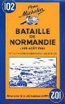
Battle of Normandy Historical Map. 1:200,000. Michelin. This is a reprint map of a 1944 Michelin map showing the Battle of Normandy. The map shows the Allied and Axis troop movements and battle sites. Bilingual..
64-56917
1 sheet, folded
$12.95
Battle of Provence Historical Map. 1:200,000. Michelin. This is a reprint map of a 1947 Michelin map which was produced to celebrate the liberation of France. The map shows the battle sites and troop movements for the August 1944 battle. Bilingual..
64-56918
1 sheet, folded
$13.99
(France) D-Day 6-6-44 Historical Map. IGN. This detailed map shows the locations and movements of both Allied and Axis troops during the battle of D-Day. Also shows the locations of current monuments, cemetaries, etc. In French.
64-56915
1 sheet, folded
$15.99
Battle of Saint-Malo Historical Map (Bataille de Saint-Malo). 1:40,000. IGN, 1994. This map is a reproduction of a 1944 era map showing the troop movements and battle sites for the Battle of Saint-Malo from August 2 to September 2 1944. In French.
64-56921
1 sheet, folded
$12.95
Western Front Map for WWI. Footstep Maps, Australia. The map has a main map, a collection of inset maps, photographs and descriptive text. The main map gives an overview during different stages of the war. Inset maps are current road maps around major battlefield areas (Verdun, etc.) with battlefield information, museums, cemeteries, etc. 112 x 89 cm.
Sample #1 Sample #2


 Thumbnail of the entire poster
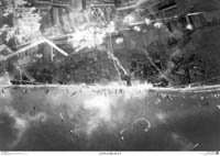
 Thumbnail of the entire poster
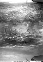
 Thumbnail of the entire poster
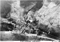
 Thumbnail of the entire poster
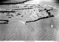
 Thumbnail of the entire poster
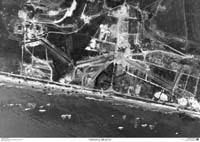
 Thumbnail of the entire poster
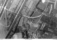
 Thumbnail of the entire poster
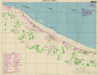
 Thumbnail of the entire map
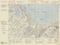
 Thumbnail of the entire map
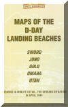
 Sample of the detail.


 Sample #1
 Sample #2