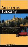
Recommended! Authentic Italy Guides. Touring Club Italiano. Travelers looking for the "true essence" of Italy need look no further than the Authentic Italy series from the Touring Club of Italy. These guidebooks offer a uniquely Italian perspective on the regions that only TCI, with more than 100 years of experience providing reliable information to travelers, can provide.
With detailed maps, these guides include everything readers need to discover the delights of the region at their own pace. The subject-keyed design allows readers to quickly scan daily activities and focus in on their particular location. Illustrated throughout with graphics, maps, and photos from the extensive TCI archives, these guides rate restaurants, hotels, B&Bs, villa rentals, spas, and retreats; explores food/regional specialties, with profiles on each category; suggests one-, two-, and three-day itineraries, emphasizing walking tours, special interest tours (wineries, olive oil, ceramics, etc.), and biking routes; outlines an array of shopping options, covering local artisans and handicrafts, markets (antiques, flea markets, craft fairs), outlets, and factory tours; and includes a calendar listing musical, cultural, and food festivals and events.
Sample page from the Authentic Tuscany guide
$24.95
64-82953IT
Authentic Italy. 2005.
$18.95
64-82953SA
Authentic Sardinia. 2005.
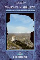
Walking Abruzzo. Cicerone.
Essential guidebook for anyone walking in Abruzzo. This wild region of Italy is home to the Abruzzo, Maiella, and Gran Sasso national parks and the Sirente-Velino regional park. 30-day walks are described including an ascent of Como Grande, the highest point in Italy outside the Alps. The area is easily reached from the airport at Pescara.
Abruzzo is one of the wildest and least populated regions of Italy, with 26 peaks over 2000m, and home to three national parks. There are fine routes throughout this largely protected area, between charming hilltop villages through forests and gorges and along high mountain ridges.
30 walks described in four areas across the region
Walking on the Amalfi Coast. Cicerone, May 2010. The steep southern edge of the Sorrento peninsula, on the Gulf of Naples, is famous for its medieval villages perched above plunging cliffs with near-vertical vineyards and lemon orchards. Combined with the rugged landscape of the Monti Lattari further inland, and the idyllic islands of Capri and Ischia, this whole region also makes a perfect holiday destination for walkers.
This new guide introduces readers to a wide range of routes from family strolls to strenuous climbs. The guide to walking the Sorrento Peninsula, Amalfi Coast and Monti Lattari, from Positano, Sorrento and Amalfi, and also the islands of Capri and Ischia in the Gulf of Naples, Italy, Europe. 30 graded day walks for all abilities. A UNESCO World Heritage site crossed by a network of ancient mule tracks and great public transport links.
World Heritage Site criss-crossed by ancient mule tracks and pilgrim routes for easy navigation
Trekking in the Dolomites - Alta Via 1 and 2. Cicerone Press.
Situated towards the eastern end of the Alps' great curve from the Mediterranean coast through central Europe to the Balkans, the Dolomites region occupies an area of northern Italy as large as Wales.
Although the Dolomites' reputation as a playground for 'hard men' is fully justified, these mountains are by no means the domain of the rock climber alone. A dense network of footpaths offers endless scope for exhilarating high-level walks; the renowned 'vie ferrate' (rock routes aided by fixed metal ladders and cables) lead up into many sensational situations, while in winter the region becomes a premier skiing destination for thousands of Europeans.
The authors hope that these treks through the Dolomites will yield rewarding experiences and enduring memories for readers able to visit this most extraordinary region. The maps recommended by the authors are listed below.
Sketch map showing locations of the hikes described in the guide
$27.95
64-82961-1AV
Alta Via 1 Guidebook
$27.95
64-82961-2av
alta via 2 guidebook
Maps for Alta Via 1 (Alte Vie 1):
$15.99
64-8275-03
Cortina d'Ampezzo e Dolomiti Ampezzane 1:25,000 hiking map #3. Tabacco.
$15.99
64-8275-24
Prealpi e Dolomiti Bellunesi 1:25,000 hiking map #24. Tabacco.
$15.99
64-8275-25
Dolomiti di Zoldo Cadorine e Agordine - S. Vito di Cad. 1:25,000 hiking map #25. Tabacco.
Val Gardena - Alpe di Siusi/Gröden - Seiseralm 1:25,000 hiking map #5. Tabacco.
$15.99
64-8275-22
Pale di San Martino 1:25,000 hiking map #22. Tabacco.
$15.99
64-8275-23
Alpi Feltrine - Cimònega - Lè Vette 1:25,000 hiking map #23. Tabacco.
$15.99
64-8275-30
Bressanone/Brixen - Val di Funes/Villnösstal 1:25,000 hiking map #30. Tabacco.
Shorter Walks in the Dolomites Hiking Guide. Cicerone.
Guidebook to day walks in the Italian Dolomites. The 50 graded walks range from short leisurely strolls to full-day high mountain expeditions, each designed to fit into a single day. The Dolomites are an ideal walking destination from June to September, and can easily be reached from Verona, Treviso, Venice and Innsbruck airports.
Sketch map showing the areas covered by the guide
$24.95
64-82961SD
Guide.
Walking in the Dolomites. Cicerone Press.
This guide leads you through breathtaking alpine scenery flanked by well-graded paths and excellent mountain refuges that verge on hotels, which are easily accessible with the excellent network of public transport from major towns and travel hubs, such as Venice, Verona, Munich and Innsbruck.
Any one of these fabulous multi-day walks make for a memorable holiday in Italy's breathtaking Dolomite mountains. The author weaves the best of her 20-year experience and knowledge of this spectacular region into an original selection of itineraries on foot across each Dolomite group. Many walks follow mule-tracks constructed by troops during the First World War, when Italy fought Austria for possession of crazy summits and tunnels were hewn through impossible mountain-sides. The highlights are emphasised and the routes are furnished with fascinating explanations of wildlife and flowers. Everything, from a stroll through woods and meadows to family routes, steep rocky zigzag passages and hands-on clambers, is covered.
The author recommends two sets of maps by Tabacco; either 1:25,000 topos or 1:50,000 topos.
Sketch map showing locations of the walks described in the guide.
$27.95
64-82961DO
Guide
Recommended 1:25,000 Maps by Tabacco:
$15.99
64-8275-03
Cortina d'Ampezzo e Dolomiti Ampezzane
$15.99
64-8275-05
Val Gardena - Alpe di Siusi/Gröden - Seiseralm
$15.99
64-8275-06
Val di Fassa - Marmolada - Catinaccio/Rosengarten
$15.99
64-8275-07
Alta Badia - Fànes - Sella - Pútia/Peitlerkofel
$15.99
64-8275-10
Dolomiti di Sesto/Sextener Dolomiten
$15.99
64-8275-14
Val di Fiemme - Lagorai - Latemar
$15.99
64-8275-15
Marmolada - Pelmo - Civetta - Moiazza
$15.99
64-8275-16
Dolomiti del Centro Cadore
$15.99
64-8275-22
Pale di San Martino
$15.99
64-8275-23
Alpi Feltrine - Cimònega - Lè Vette
$15.99
64-8275-24
Prealpi e Dolomiti Bellunesi
Or Recommended 1:50,000 Maps by Tabacco:
$13.99
64-82751-01
Cadore - Cortina d'Ampezzo/Sextener Dolomiten
$13.99
64-82751-02
Sella - Marmolada - Fassa - Gardena / Gröden
$16.99
64-82751-04
Dolomiti Agordine e di Zoldo - Pale di San Martino
Walking in Italy's Gran Paradiso. By Gillian Price. Cicerone Press. Guidebook describing the Alta Via 2 Trek in Italy's Gran Paradiso and a range of 28 walks from gentle strolls to full scale traverses of the region. The Gran Paradiso is a protected national park. It is accessible from France and northern Italy. A range of deep valleys and passes give excellent walking. Refuge and valley accommodation is plentiful.
Sketch map showing locations of the walks described in the guide.
$27.95
64-82961GP
Guide
$56.95
64-82961GPM
Set of 4 maps.
Hiking the Italian Lakes Guide. Cicerone Press.
This guidebook describes 50 walks around Lakes Como, Iseo, Garda and Maggiore in Northern Italy. The picturesque routes are accessible by public transport from popular centres including Bellagio, Riva, Stresa and Cannero, and range from 2 to 14km in length. There are gentle lakeside strolls, and numerous ridge routes and traverses as well as the ascent of Monte Baldo, Monte Boletto and other walker's peaks in the region. The clear maps, inspirational photographs and information about accommodation and public transport options help to make this guidebook an ideal companion to exploring the exceptional scenery, views and culture of the Italian Lakes. A basic English-Italian glossary is also included.
Sketch map showing area covered
$24.95
64-82961LA
Guidebook.
Italy's Sibillini National Park guide. Cicerone.
An inspirational guidebook to walking and trekking in Italy's Sibillini National Park includes the GAS, Grande Anello dei Sibillini, 8-day trek. Easily reached from airports on the Adriatic coast and from Rome, the Monti Sibillini belong to the Appenine chain that straddles the Marche and Umbria, and will become a popular walking destination.
Little known to foreign visitors, the Sibillini, in Italy's central Apennine chain, comprise soaring limestone mountains and awe-inspiring natural landscapes inhabited by wonderful wildlife. Rugged lofty ridges link dizzy peaks above vast bare flanks swept by howling winds. Vast grassy uplands are smothered with vivid wildflowers. In dramatic contrast, worlds below, plunging gorges are run through with deliciously cold streams. The thickly wooded valleys are dotted with utterly charming historic villages, home to herders and woodcutters, hard-working reticent folk with a great sense of hospitality. With a good 50 peaks, many over 2000m, there is plenty of exploratory walking to be done in the Sibillini on the intricate web of pathways and old cart tracks. Thanks to dedicated nature lovers and environmental activists, in 1993 this wonderland finally became the Parco Nazionale dei Monti Sibillini, encompassing 700km&2sup;.
Sketch map of the area covered by this guide
$24.99
64-82961AM
Guide.
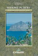
Walking in Sicily. Cicerone. Walking across this breathtaking island is a journey through time. Sicily offers wild vallyes pitted with ancient Greek and Roman temples, olive groves and citrus orchards, snow-clad mountain ranges and islands presided over by visitable volcanoes - ranging from those extinct
or placidly smoking to others issuing fiery rivers of lava. Mule tracks and age-old pathways have survived and reserve a wealth of surprises. Sicily's varies range of landscapes, combined with its mild winters and hot dry summers, make walking holidays feasible all year round, facilitated by good roads, a capillary network of public transport,
a wide range of accommodation and some memorable eating places.
$24.95
64-82961SI
Guidebook.
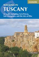
Walking in Tuscany. Cicerone.
This guide offers suggestions for exploratory walks through the picture postcard landscapes of Tuscany, Umbria and Latium. Once known as Etruria, it was home to the ancient and enigmatic people who preceded the Romans.
The book has 50 itineraries ranging from brief strolls to the Chianti Trail, a five-day trek, taking in little-known Etruscan marvels such as ancient sunken roads and monumental tombs. Walkers are guided through medieval hamlets, exquisite Romanesque churches, unspoilt coast and countryside alive with wild life and carpeted with wild flowers and aromatic herbs. There's the wild Chianti ridge, city walks through Perugia, Orvieto and Voltera, day walks on the divine island of Elba and along the unspoilt coast around Orbetell.
A mass of practical details cover accommodation in farms, country hotels, convents and hostels, with notes on local specialities in the food and drink field. Visitors are encouraged to use the public transport system so as to minimise impact. The aim of this walking guide is to encourage people to get out of their car and explore the are on foot. A series of walks is presented to take visitors through the maze of age- old tracks and discover the delights of the Tuscan and surrounding countryside, often meaning fascinating little known Etruscan sites. There are mysterious tombs excavated out of volcanic tufa cliff sides, original sunken roadways, dominating acropolis sites and impressive sanctuaries, all set in inimitable picture postcard countryside.
The author recommends nine maps to accompany this guide.
$27.95
64-82961TU
Guide
Recommended maps:
$15.99
66-2273-2458
#2458. Firenze - Siena - Chianti map. 1:50,000. Kompass.
$13.99
66-2273-X661
#661. Siena - Chianti - Colline Senesi map. 1:50,000. Kompass.
$13.99
66-2273-X662
#662. Chianciano Terme map. 1 :50,000. Kompass.
$18.99
64-82744-040
Sheet 40/41. Monte Amiata, Val d'Orcia map. Castel del Piano, Arcidosso, S. Fiora, Abbadia s. Salvatore, Piancastagnaio, Roccalbegna, Seggiano, Radicofani, Castiglione d'Orcia, Bagno Vignoni.
$13.99
64-82743-504
Parco Dell' Uccellina, Monte Argentario map.
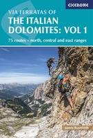
Via Ferratas of the Italian Dolomites - two volumes. Cicerone Press.
Book two documents southern Dolomites Via Ferrata routes in the major mountain ranges of Civetta, Schiara and Pala as well as those to the west in the Brenta. A significant addition (and, as far as we are aware, not previously published in any English language guidebook) is the inclusion of routes around the northern end of Lake Garda and the Piccole Dolomites north of Vicenza. Here the mountains are generally lower and you can enjoy ferrata climbing over a much extended season, with some routes accessible for most of the year.
Volume One covered the eastern, northern and central areas of the Dolomites, Volume Two completes the picture, focusing on the southern, Brenta and Lake Garda areas.
$26.95
64-82961VF
Vol. 1 - North, Central, East
$21.95
64-82961VG
Vol. 2 - South
Recommended maps:
$15.99
64-8275-01
Sappada - S. Stefano - Forni Avoltri - Val Visdende map. 1:50,000. Tabacco.
$15.99
64-8275-02
Forni di Sopra - Ampezzo - Sauris - Alta Val Tagliamento map. 1:50,000. Tabacco.
$15.99
64-8275-04
Val Senales - Altissima/Schnalstal - Hohe Wilde map. 1:50,000. Tabacco.
 Recommended!
 Sample page from the Authentic Tuscany guide
 Sketch map of the area covered by this guide
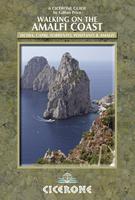
 Sketch map of the area covered by this guide
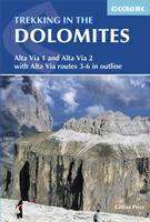
 Sketch map showing locations of the hikes described in the guide
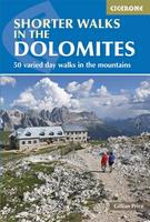
 Sketch map showing the areas covered by the guide
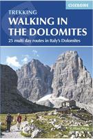
 Sketch map showing locations of the walks described in the guide.
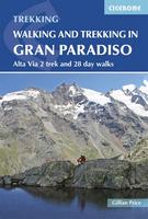
 Sketch map showing locations of the walks described in the guide.
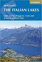
 Sketch map showing area covered
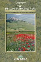
 Sketch map of the area covered by this guide