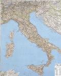
Italy Classic Political Wall Map. 1:1,800,000. National Geographic Maps. A political map with striking shaded relief and city inset maps. A historical map, interesting facts, and illustrations are provided overleaf. Printed on both sides. ISBN 1-57262-165-6. Size 23-1/4" x 34".
An image of the full map A detail of the map An image of the reverse side A sample of the legend
64-82488
Flat/rolled
$14.99
64-82488L
Laminated
$19.99
Italy Shaded Relief Wall Map. 1:1,000,000. Litographia Artistica Cartographica. Shaded relief map to show elevation; also shows political boundaries. Size is 51 x 40", in Italian.
Thumbnail of the entire map Detail of part of the map
64-82487
Flat/rolled
$24.99
64-82487L
Laminated
$39.95
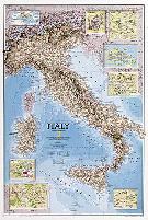
Italy Wall Map - Executive Style. 1:1,765,000. National Geographic Maps. This elegant, richly colored antique-style map features the incredible cartographic detail that is the trademark of National Geographic quality. In addition to detailed political information - country boundaries, roads, cities and towns, lakes and waterways, etc. - our map of Italy also includes helpful inset maps for San Marino, Milan, Venice, Florence, Rome and other famous cities. Size is 23 x 34 inches.
Thumbnail image of the entire map Sample of the map detail.
64-82420
Small, flat
$14.99
64-82420L
Small, laminated.
$19.99
Map Pins & Map Dots for use with Wall Maps!
Click here to see our listings of map pins, map tacks, and transparent map dots, all for use with wall maps.
Italy Topographic Quadrangle Maps
Italy Topographic Quadrangle Maps. There are several different topographic series for Italy, none of which offer complete coverage of Italy. They are also expensive and difficult to obtain. Both the 1:50,000 series and the 1:25,000 are under revision.
The 1:25,000 series was started in 1879, and many sheets are pre-1900's editions and no longer available. The new series sheets are shown on the index maps in yellow - the old series in white.
The 1:50,000 series was started in 1964. The new 1:50,000 series uses 5-meter supplemental contours with 25-meter major contours, used the UTM coordinate
system and the International Spheroid. The 1:200,000 series has been discontinued and replaced by the 1:250,000 series (Italian-produced JOGs). We have both in stock.
Italy 1:25,000 Topographic Map Series. On the index maps, the colored quads are those in print; the date is the publication date.
Northern Italy index map - current and fast-loading. Southern Italy index map - current and fast-loading. Italy 1:25,000 Index for North-North-western Italy - detailed.
Italy 1:25,000 Index for North-North-eastern Italy - detailed.
Italy 1:25,000 Index for North-western Italy - detailed.
Italy 1:25,000 Index for North-eastern Italy - detailed.
Italy 1:25,000 Index for Central-western Italy - detailed.
Italy 1:25,000 Index for Central-eastern Italy - detailed.
Italy 1:25,000 Index for South-western Italy - detailed.
Italy 1:25,000 Index for South-central Italy - detailed.
Italy 1:25,000 Index for South-eastern Italy - detailed.
Italy 1:25,000 Index for Southern Italy - detailed.
Italy 1:25,000 Index for Sicily - detailed.
Italy 1:25,000 Index for Sardinia - detailed.
64-8249
1:25,000
$29.95
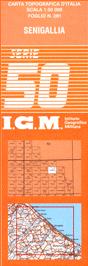
Italy 1:50,000 Topographic Map Series. On the index map, colored quads are those in print; date is date of publication. Please note that these files are large and may be a little slow in loading.
Italy index - current and fast-loading. Italy 1:50,000 Index for Northern Italy - detailed index.
Italy 1:50,000 Index for Central-western Italy - detailed index.
Italy 1:50,000 Index for Central-eastern Italy - detailed index.
Italy 1:50,000 Index for Southern Italy - detailed index.
Italy 1:50,000 Index for Sardinia - detailed index.
Detail of the map #1. Detail of the map #2. Thumbnail a map sheet.
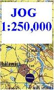
Italy 1:250,000 Topographic Map Series (JOG charts). 1:250,000. IGM. The 1:250,000 series offers complete coverage of Italy in 39 sheets. These are bilingual joint production (Italy/NIMA) JOG charts, primarily air, but some ground charts.
64-8254-NJ-32-02
Nuoro.
$24.00
64-8254-NJ-32-05
Cagliari.
$24.00
64-8254-NJ-33-03
Cosenza.
$24.00
64-8254-NJ-33-04
Crotone.
$24.00
64-8254-NJ-33-05
Trapani.
$24.00
64-8254-NJ-33-06
Palermo.
$24.00
64-8254-NJ-33-07
Messina.
$24.00
64-8254-NJ-33-08
I. di Capo Rizzuto.
$24.00
64-8254-NJ-33-09
Alcamo.
$24.00
64-8254-NJ-33-10
Caltanissetta.
$24.00
64-8254-NJ-33-11
Catania.
$24.00
64-8254-NJ-33-13
Pantelleria.
$24.00
64-8254-NJ-33-14
Ragusa.
$24.00
64-8254-NJ-34-01
C.S. Maria di Leuca.
$24.00
64-8254-NK-32-02
Imperia.
$24.00
64-8254-NK-32-03
Firenze.
$24.00
64-8254-NK-32-06
Grosseto.
$24.00
64-8254-NK-32-11
Sassari.
$24.00
64-8254-NK-33-01
Perugia.
$24.00
64-8254-NK-33-04
Terni.
$24.00
64-8254-NK-33-05
Pescara.
$24.00
64-8254-NK-33-07
Roma (Rome).
$24.00
64-8254-NK-33-08
Foggia.
$24.00
64-8254-NK-33-09
Bari.
$24.00
64-8254-NK-33-10
Ischia.
$24.00
64-8254-NK-33-11
Napoli.
$24.00
64-8254-NK-33-12
Taranto.
$24.00
64-8254-NK-34-10
Lecce.
$24.00
64-8254-NL-32-05
Lugano.
$24.00
64-8254-NL-32-06
Bolzano.
$24.00
64-8254-NL-32-07
Torino.
$24.00
64-8254-NL-32-08
Milano.
$24.00
64-8254-NL-32-09
Verona.
$24.00
64-8254-NL-32-10
Cuneo.
$24.00
64-8254-NL-32-11
Genova.
$24.00
64-8254-NL-32-12
Bologna.
$24.00
64-8254-NL-33-04
Udine.
$24.00
64-8254-NL-33-07
Venezia.
$24.00
64-8254-NL-33-10
Ravenna.
$24.00
64-82541
Complete set of 39 sheets.
$750,00
Italy City Topographic Maps. 1:10,000. Soviet government. These maps are regular topographic maps that include contour lines, power lines, rail/trolley lines, etc. In Russian. We are sold out except for Trieste.

 An image of the full map
 A detail of the map
 An image of the reverse side
 A sample of the legend
 Thumbnail of the entire map
 Detail of part of the map
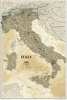
 Thumbnail image of the entire map
 Sample of the map detail.

 Northern Italy index map - current and fast-loading.
 Southern Italy index map - current and fast-loading.


 Italy index - current and fast-loading.


 Detail of the map #1.
 Detail of the map #2.
 Thumbnail a map sheet.