Ontario wall map. Laminated. With FSA code overleaf. 40 x 49".
$49.95
64-3693QW
Quebec wall map. Laminated. 28 x 40".
$39.95
64-3693TW
Toronto wall map. Laminated. 48 x 77".
$99.95
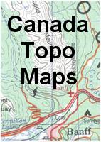
Canada Topographic Maps & Physical Maps
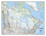
Relief Map of Canada. 1:6,000,000. National Atlas of Canada map MCR 101, Canada Map, 1998. An attractive relief map of Canada showing relief shading, isobaths, communications systems, province boundaries, etc. Includes three inset maps on physiography, drainage, and vegetation. Size is 108 x 91 cm. In English.
64-26460
1 sheet, flat.
$12.95
Canada--Topographic Quadrangle Maps. Canada Map Office. We stock all of the 1:50,000 and the 1:250,000 topographic maps.


 An image of the reverse side of the map
 A detail of the map
 A sample of the legend
 An enlarged view of the mounted map