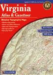
Virginia Topographic Atlas and Gazetteer. 1:150,000. DeLorme.
Gazetteer information usually includes campgrounds, attractions, historic sites & museums, recreation areas, trails, freshwater fishing sites & boat launches, canoe trips or scenic drives, etc. (Categories vary slightly by state and available recreation opportunities.)
$29.95
62-9848
Atlas
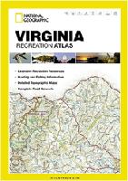
Virginia Recreation Atlas. National Geographic Maps.
This durable, easy-to-use atlas includes up-to-date topographic maps, a comprehensive road network, informative recreation guides, and a detailed index. All road types are clearly identified, making each atlas a useful planning tool for motorcycle and off-road adventures. Maps include bold boundaries for parks and federal lands, and clearly labeled lakes, rivers, and streams. On each map page you will find a convenient map legend, easy-to-read page numbers, a latitude and longitude grid for use with GPS, and fact-checked points of interest. Also included are cross-referenced charts of fishing areas with species information, game management units, campgrounds and attractions charts, state park maps and facilities, hiking, golfing, skiing and paddling destinations, climate information, and more.
Sample detail from the Virginia Recreation Atlas
Virginia & West Virginia Road Atlas. American Map.
The Virginia - West Virginia Travel Atlas is a full-color street atlas that includes 44 Cities @ Street Detail. Atlas also features: Airports, Attractions, Colleges & Universities, Golf Courses, Museums, Parks & Rec Areas & Places of Interest.
$29.99
62-98891
Atlas
Virginia Road Maps - Paper Maps
Virginia Road Map. Rand McNally.
This detailed road map includes points of interest, state park chart, State mileage chart, Driving times map, Visitor center information, Climate data, State facts & symbols, Easy-to-use legend, and a detailed index. Includes small inset maps of Alexandria/Arlington, Bristol, Charlottesville, Hampton Roads: Norfolk/Newport News/Virginia Beach, Lynchburg, Richmond/Petersburg, Roanoke, Shenandoah National Park, Washington, D.C. & Vicinity, and Williamsburg/Colonial National Historic Monument. Map size is 26 x 37 inches unfolded.
$7.99
62-9890
1 sheet, folded
Virginia Road Map. Map Supply.
Map Supply is a NC-based regional map publisher and produces an excellent road map of Virginia. Includes inset maps of several major cities, fully indexed, and much more.
Sample detail from the Virginia road map.
Virginia Official State Transportation Map 2012-2014. Virginia DOT.
This is the official road map for Virginia, published by the Virginia state government. One side has a road map of the state with an index to cities/towns/communities. The reverse side has 26 inset city maps. The maps are too small to show city streets, rather they show the main roads through and around the cities.
$1.00
62-98909
1 sheet, folded.
A Map of Scenic Roads in Virginia. Virginia DOT.
This simplified road map of Virginia highlights with color-coding the scenic routes in Virginia. Three types are shown: Virginia Byways, Scenic Roads, National Scenic Byways and All-American Roads. Also color-coded are connector routes to scenic routes and other highways and main roads. The reverse side highlights seven of the best routes and shows a more detailed map of that area with descriptive text.
Front of the Virginia Scenic Routes Map
$1.00
62-98910
1 sheet, folded.
Virginia & the Carolinas Road Map. Map Supply.
Detailed road map of the three mid-Atlantic states of South Carolina, North Carolina, and Virginia, all in one map. The reverse side includes 15 city inset maps, ranging from Washington D.C. to Charleston to Richmond to Raleigh. Fully indexed.
Sample detail from the Virginia & Carolinas road map.
$5.95
62-85904
1 sheet, folded
Northern Virginia Road Map. Rand McNally.
This detailed road map has clearly labeled Interstate, U.S., state, and county highways; One-way streets indicated; Indications of county boundaries, schools, shopping malls, parks, golf courses, hospitals, airports, and points of interest; Easy-to-use legend; and a detailed street index. Map size is 28 x 40 inches unfolded.
$6.99
62-98907
1 sheet, folded
Virginia Road Maps - Laminated Maps
Virginia Easy-to-Fold Laminated Road Map. Rand McNally
The durable and convenient Virginia EasyToFold state map will take all the wear and tear your journey can dish out. The heavy-duty laminated design allows you to mark your route, make notes, then wipe the surface clean for further use. Clearly indicated highways, county boundaries, points of interest, and more. Quick-reference legend and city index. Map size is 17 x 18 inches unfolded, ideal for using in a car.
$9.99
62-98901
1 sheet, folded
Virginia State Guide Map. National Geographic Maps.
The front side is an easy-to-read road map with insets of - Washington DC area - Charlottesville - Lynchburg - Roanoke - Southwest Virginia - Colonial National Historical Park The back includes: - Maps and information for Richmond and Hampton Roads - Information for Shenandoah National Park - Points of interest - Scenic drive - Park Service sites in Virginia. Map size is 18 x 25 inches.
Sample detail from the Virginia State Guide map. Front of the Virginia State Guide map. Back of the Virginia State Guide map.
$7.95
62-98903
1 sheet, folded
Virginia City Maps - Paper Maps
Virginia City Maps.
Blacksburg City Map - covered on Roanoke map below.
$4.95
62-9892DA
Danville & Martinsville City Map. (Map Supply).
$6.99
62-9892FRE
Fredericksburg, Spotsylvania, Stafford City Map. (GM Johnson).
$4.95
62-9892HB
Harrisonburg & Rockingham County. (Map Supply).
$5.95
62-9892HAR
Harrisonburg & Rockingham County street map.
$5.95
62-9892LYN
Lynchburg, Danville, Martinsville city map. (GM Johnson).
$7.99
62-9892NP
Norfolk & Virginia Beach city map. (ADC).
$6.99
62-9892RI
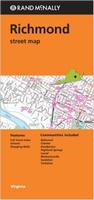
Richmond City Map. (Rand McNally).
$7.99
62-9892ROA
Roanoke City Map. (ADC). Also covers Blacksburg, Christiansburg and Radford. Out of print when sold out.
$5.99
62-9892RO
Roanoke Street Map. With Blacksburg, Christiansburg, and Radford, plus Radford University and Virginia Tech. (Seeger).
$4.95
62-9892ST
Staunton & Waynesboro & Augusta County. (Map Supply).
$5.95
62-9492TRI
Tri-Cities (Johnson City, Kingsport, Bristol) city map. (GM Johnson).
$4.95
62-9892WJ
Winchester & Front Royal City Map. (GM Johnson).
Virginia City Street Atlases
Virginia City, County & Regional Street Map Books. ADC. These are good road/street atlases, generally on a county-by-county basis. Softcover.
$18.99
62-9890LO
Loudoun County street atlas.
$25.99
62-9890NO
Northern Virginia Region street atlas.
$18.99
62-9890PR
Prince William County street atlas.
$24.99
62-9890RI
Richmond & Vicinity street atlas.
$26.99
62-98922HA
South Hampton Roads Street Atlas.
Virginia City, County, and State Business Wall Maps
Virginia City Wall Maps.
When it comes to general planning, defining delivery areas, planning direct marketing and delivering products, our city wall maps are perfect to get the detailed information you need.
These maps offer clear mapping by showing all major streets and roads, but leaving out the smaller streets.
If you want a clear map for easy planning, then these are the maps for you; if you want a map showing every little back alley, these are not for you.
We offer wall maps for Alexandria, Arlington, Burke, Chesapeake, Hampton, Harrisonburg, Lynchburg, Newport News, Norfolk, Portsmouth, Reston, Richmond, Roanoke, Suffolk, and Virginia Beach.
We offer state and county wall maps for all of the USA. The maps come in sizes from 24 x 36 to 108 x 144 inches. They are available in variety of mounting and framing options. The maps are ideal for business applications, sales territory, delivery planning, direct mail targeting and hundreds of other applications.
Virginia Bicycling Maps. Virginia is crossed by the very popular Transcontinental Cycling Trail (east-west) and the Atlantic Coast Cycling Trail (north-south). Maps for two popular loop trails are also available.
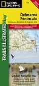
Delmarva Peninsula Map (Delware-Maryland-Virginia). 1:250,000. National Geographic Maps/Trails Illustrated #772. The new Delmarva Trails Illustrated regional topographic recreation map covers all major recreation areas for the Peninsula and Chesapeake Bay region.
This beautifully designed map includes all state parks, state wildlife areas, national wildlife areas and key recreation access points. Locations for camping, boating, canoeing/kayaking, hunting, biking/greenways, and fishing are displayed. Highlights include Blackwater and Chincoteague National Wildlife Refuges, Assateague Island National Seashore, Cape Henlopen State Park, and Maryland's Eastern Shore. This map will be an essential trip planning tool, road map, and on-the-ground guide for accessing Delmarva Peninsula's public lands. Map size is 25-1/2 x 37-3/4".
Index of map coverage Thumbnail of the front of the map. Thumbnail of the reverse of the map Detail from the map.
Mt. Rogers benchmark paperweight. Geo-Situ. Whether you're a climber, hiker, geography buff, or armchair traveler, you'll love to collect or give these unique bench mark paperweights that celebrate the spirit of exploration, athletic challenge, and personal achievement. Cast in pewter these summit marker paperweights are exact replicas of official USGS benchmark markers. Please click the "sample" button below to see an enlargement of the paperweight. Each marker has a soft felt pad on the bottom so these can be used on glass, wood, or any surface. Supplied in a soft fleece drawstring pouch, 3¼" diameter.
Larger image of the Mt. Rogers paperweight.
$59.95
62-9897RO
Paperweight.
Virginia Wall Maps
Virginia State and County Wall Maps. Intelligent Direct.
Click here to order county wall maps and to see sample images, descriptions, and prices.
Click here to order state wall maps and to see sample images, descriptions, and prices.
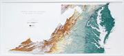
Virginia/Delaware/Maryland Raven State Wall Map. 1:500,000. Raven Press.
This regional map is centered on Virginia, but also covers Maryland and Delaware. Elevations are represented by color. Raven's shaded relief technique makes the mountains and elevation differences stand out. One sheet flat, size is 34 x 65", available either as a paper map or laminated.
Thumbnail of the map. Sample of the detail.
$40
62-9851
1 sheet flat/rolled
$65
62-9851L
Laminated
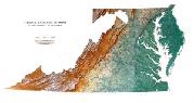
Virginia Topographic Map. 1:500,000. USGS. 1973.
A large (20 x 62 inches) single-sheet topographic map of Virginia, with contour lines. The maps show roads, county boundaries, etc. The shaded relief map lacks the contour lines and uses shaded relief to show mountains, etc.
Thumbnail of the Virginia topographic map. Thumbnail of the Virginia shaded relief map.
$15.99
62-9850
Contoured topographic map
$29.99
62-9850L
Topographic map, laminated
$15.99
62-98501
Shaded relief map
$29.99
62-98501L
Shaded relief map, laminated
Shark Attack Poster of the Atlantic Ocean and the Gulf of Mexico. Sealake Products.
This fascinating, educational print shows the locations of over 300 shark attacks in the Atlantic and Gulf of Mexico from 1905 to the present. 35 hair-raising encounters
are detailed, including the 1916 attacks in New Jersey. Plus, you'll learn interesting facts about the 12 types of sharks blamed for the attacks. Also, an actual size tooth from each of the three most dangerous sharks is shown. Size is 24 x 36". Available rolled/flat, either as plain paper or laminated.
Shipwrecks of the Delmarva Peninsula Chart. 1:414,500. National Geographic Maps, 2010. Shipwrecks of Delmarva shows the location of over 2,400 wrecks from the waters off the Delaware coast to the waters of the Chesapeake Bay, displayed atop beautiful bathymetric and coastal detail. Each wreck site is symbolized to define the class, type, and name of vessel accompanied by their dates of sinking. Locations of lifesaving stations, lighthouses and lightships, along with navigational beacons are accurately marked. Bathymetric and coastal features are clearly labeled, accompanied by inset maps, captions, and drawings used to highlight unique historical events such as the sinking of the U.S.S. Cumberland, the German U-Boat offensives, and the ghost fleet of Mallows Bay - the largest assemblage of wooden ships in the Western Hemisphere. Size is 28 x 35 inches.
Image of the Shipwrecks of the Delmarva map Sample of the Shipwrecks of the Delmarva map
$19.99
62-7283
1 sheet flat
$29.99
62-7283L
Laminated.
Virginia Shipwrecks Chart. Sealake. Did you know that there were over 1,100 shipwrecks off the Virginia coast during the period from 1874 to 1915, and this doesn't even include those in Chesapeake Bay? Add to this the rich history of this area, including the Battle of Yorktown during the Revolutionary War, the Monitor and the Merrimac , the German U-boats, and the luxury steamships that once traversed the Chesapeake, and you can see what makes this chart is so interesting.
Shipwrecks of Virginia and the Southern Chesapeake Bay has over 500 shipwrecks on it (general locations only) along with the stories of how 35 of the more interesting shipwrecks occurred. These cover the time period from the Revolutionary War (HMS Guadeloupe) up to 1979 when the USCG Cuyahoga collided with the freighter Santa Cruz II with a tragic loss of life.
Also shown on the chart are interesting facts and nautical lore about the Civil War, Collisions at Sea, the Life-Saving Service, the Lighthouses, and World War II.
This chart is beautifully done in color, with the jagged coastline of Chesapeake Bay and the Eastern Shore of Virginia along adding to its impact. Size is 21" x 23."
Thumbnail image


 Sample detail from the Virginia Recreation Atlas
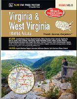

 Sample detail from the Virginia road map.

 Front of the Virginia Scenic Routes Map
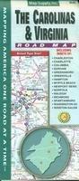
 Sample detail from the Virginia & Carolinas road map.


 Sample detail from the Virginia State Guide map.
 Front of the Virginia State Guide map.
 Back of the Virginia State Guide map.


 Sample detail from the Richmond wall map.
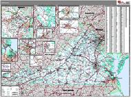 Virginia County and State Wall Maps.


 Virginia Raised Relief Maps.

 Index of map coverage
 Thumbnail of the front of the map.
 Thumbnail of the reverse of the map
 Detail from the map.
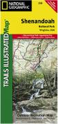 Waterproof!
 Index for the Virginia series
 Sample #1 of the map detail.
 Sample #2 of the map detail from the Shenandoah map.
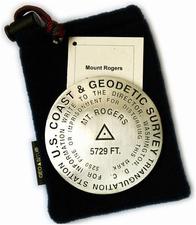
 Larger image of the Mt. Rogers paperweight.
 Thumbnail of the Virginia map.
 Sample detail of the Virginia map.
 Thumbnail of the Virginia map with colored counties.
 Sample detail of the Virginia map with colored counties.
 Thumbnail of the map.
 Sample of the detail.
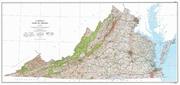 Virginia Topographic Map. 1:500,000. USGS. 1973.
 Thumbnail of the Virginia topographic map.
 Thumbnail of the Virginia shaded relief map.
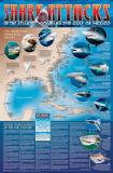
 Image of the entire poster
 Sample of the map detail, covering Florida.
 Sample of the Great White Shark text.
 Sample of the text describing the attacks.
 Image of the entire Mid-Atlantic Lighthouses map.
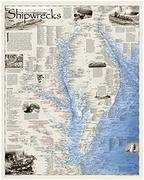
 Image of the Shipwrecks of the Delmarva map
 Sample of the Shipwrecks of the Delmarva map
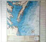
 Thumbnail image
 Virginia Flags