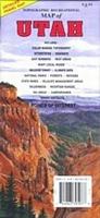
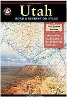
Utah Road and Recreation Atlas. Benchmark Maps.
1:400,000. This atlas is designed to help residents and visitors make the most of the wealth of attractions that Utah has to offer. You'll find hundreds of recreation sites, fishing spots, and hunting areas and a myriad of other things to do. The Landscape Maps show all drivable Utah roads, classed by surface and purpose, and thousands of campgrounds along with other destinations.
Sample detail from the Utah recreation atlas.
$26.95
62-96482
Atlas
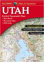
Utah Atlas & Gazetteer. DeLorme.
An excellent topographic road atlas. This atlas uses topographic maps as base maps, adds in all of the backroads, and numerous pages of outdoor recreation listings, including state and local parks, campgrounds, fishing spots, and much more. A must for hikers and backroad enthusiasts. Softcover.
$29.95
62-9648
Each
Utah Road Maps - Paper Maps.
Utah Recreation Road Map. 1:792,000. GTR
GTR. Detailed travel map - Interstates, exit numbers, highways, most local maintained roads. Topographic contours each 1,000 feet. Color shaded each 2,000 feet above 6,000 feet. Features include national forests, wilderness, campgrounds, parks, state wildlife management areas, ski areas, mining districts, points of interest, and more.
Sample detail #1 from the Utah recreation map. Sample detail #2 from the Utah recreation map.
$4.95
62-9691
1 sheet, folded.
Utah Recreation Road Map. 1:730,000. Benchmark Maps.
A highly-detailed recreation map for Utah printed on waterproof synthetic paper. Public lands, extensive backcountry road detail, recreation listings, and a Salt Lake and vicinity map are featured.
Sample detail from the Utah recreation map.
$9.95
62-96901
1 sheet, folded.
Utah Road Map. 1:601,920. Rand McNally.
Rand McNally's folded map for Utah is a must-have for anyone traveling in or through the state, offering unbeatable accuracy and reliability at a great price. The map includes inset maps of Arches National Park, Bryce Canyon National Park, Canyonlands National Park, Capitol Reef National Park, Logan, Ogden, Provo, St. George, Salt Lake City & Vicinity, Salt Lake City Downtown, and Zion National Park. Map size is 28 x 40 inches unfolded.
Utah has a wide range of sites, including the Mormon Temple in Salt Lake City; The Great Salt Lake to its west; and the Bonneville Salt Flats at its western edge, where so many speed records have been won. Utah also has two of Americas most scenic national parks: Zion in the southwest and Canyonlands in the southeast. Colorado is well-known for the Rocky Mountains, its world-famous ski areas, several National Parks, and world-famous hiking and mountain biking regions.
Front of the Colorado and Utah travel map. Reverse of the Colorado and Utah travel map.
$8.95
62-20913-CU
1 sheet, folded.
Arizona & Utah National Parks Grand Circle Road & Recreation Map. Variable scales. Great Pacific Maps.
Comprehensive coverage of Southern Utah (south of I-70) and Northern Arizona
Detailed inset maps of Arches, Bryce Canyon, Canyonlands, Grand Canyon and Zion National Parks + Grand Canyon Village.
"Grand Canyon Regional Access Map" shows highway, scheduled airline and Amtrak access to the Grand Canyon National Park area.
Quality cartography by California State Automobile Association (CSAA) and Great Pacific Recreation & Travel Maps.
Comprehensive Community and recreation indexes. Phone & website and National Park directories.
Map features include an array of geographic features (mountains, buttes, canyons, basins, deserts, etc.), airports, BLM recreation areas, hiking trails, marinas, museums & historic places, off-road vehicle areas, ranger stations, Scenic Byways & Backways, scenic overlooks, State Parks, US National Forests, US Forest Service Roads, visitor centers, wilderness areas and wildlife watching areas.
Comprehensive mileage chart and mileage map.
$5.95
62-96817
1 sheet, folded.
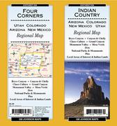
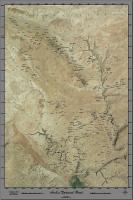
Utah's Indian Country & Four Corners Road Map. 1:736,000. GM Johnson.
This detailed road map centers on the Four Corners area of Utah/Arizona/Colorado/New Mexico. The map covers the National Parks and National Monuments of Bryce Canyon, Canyon de Chelly, Chaco Culture, Grand Canyon, Monument Valley, Mesa Verde, and Zion. The map also highlights local areas of interest and Indian lands and points of interest.
$5.95
62-19447
1 sheet, folded.
Utah Road Maps - Laminated Maps.
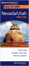
Laminated Utah and Nevada Easy-to-Fold® Road Map. 1:2,052,864. Rand McNally.
The durable and convenient Nevada and Utah EasyToFold state map will take all the wear and tear your journey can dish out. The heavy-duty laminated design allows you to mark your route, make notes, then wipe the surface clean for further use. Map size is 17 x 18 inches unfolded, ideal for using in a car.
$9.99
62-80904
1 sheet, folded.
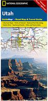
Waterproof Utah Destination Road Map. National Geographic Maps.
The front side is an easy-to-read road map with insets of: - Ogden - Logan The back includes: - Map and information for Salt Lake City - Information for Bryce Canyon, Arches, and Zion National Parks - Points of interest - Scenic drive - Park Service sites in Utah. Map size is 18 x 25 inches.
Sample detail from the Utah Destination map. Front of the Utah Destination map. Reverse of the Utah Destination map.
$7.95
62-96903
1 sheet, folded.
Utah City Maps - Paper Maps.
Salt Lake City Street Map. GM Johnson
This detailed map includes street-level detail of Salt Lake City, plus surrounding communities such as Draper, Midvale, Murray, Sandy, South Jordan, West Jordan, etc. It also has a Salt Lake City vicinity map.
$5.95
62-9692SAL
1 sheet, folded.
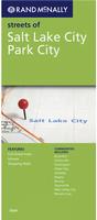
Salt Lake City Street Map. Rand McNally.
Rand McNally's folded map featuring the streets of Salt Lake City is a must-have for anyone traveling in and around this part of Utah, offering unbeatable accuracy and reliability at a great price. The map also covers Holladay, Midvale, Murray, Sandy, South Jordan, South Salt Lake, Taylorsville, West Jordan, and West Valley City. Map size is 40 x 28 inches unfolded.
$6.99
62-9692S
1 sheet, folded.
Utah City Maps.
$4.95
62-9692LO
Logan street map. (GM Johnson).
$5.95
62-9692OG
Ogden/Layton Street Map. (GM Johnson).
$5.95
62-9692PA
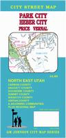
Park City street map. (GM Johnson).
$4.95
62-9692PR
Provo/Orem City Map. (Universal).
$5.95
62-9692STG
St. George & Cedar City street map. (GM Johnson).
Utah City Street Atlases.
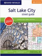
Salt Lake City Street Guide Atlas. Rand McNally.
Rand McNally's Street Guide for the Salt Lake City area (including Logan, Ogden and Provo) is all you need to get from point A to point B around Utah's largest city. Our easy-to-use, comprehensive guide features clear, detailed street-level maps, and the bold design compliments the enhanced cartography within. The convenient lay-flat spiral binding allows for easy reference on the road.
$24.95
62-9692SS
Atlas.
Utah City, County, and State Business Wall Maps
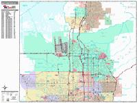
Utah City Wall Maps.
When it comes to general planning, defining delivery areas, planning direct marketing and delivering products, our city wall maps are perfect to get the detailed information you need.
These maps offer clear mapping by showing all major streets and roads, but leaving out the smaller streets.
If you want a clear map for easy planning, then these are the maps for you; if you want a map showing every little back alley, these are not for you.
We offer wall maps for Layton, Lehi, Ogden, Orem, Provo, Salt Lake City, Sandy, South Jordan, St. George, Taylorsville, West Jordan, and West Valley City.
We offer state and county wall maps for all of the USA. The maps come in sizes from 24 x 36 to 108 x 144 inches. They are available in variety of mounting and framing options. The maps are ideal for business applications, sales territory, delivery planning, direct mail targeting and hundreds of other applications.
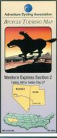
Utah Bicycling Maps. There is one popular long-distance trail in Utah - the Western Express TransAmerica Trail that crosses Utah through the beautiful National Parks and red rock county. We also stock cycling maps for the Grand Canyon Connector (Cedar City to the Grand Canyon and on to Tempe), and the Red Rocks Loop Trail.
Click here for 1:250,000 sectional raised relief maps.
Geologic Map of Arches National Park. Utah Division of Natural Resources. 1:50,000. 1985.
This colorful map includes stratigraphic columns, references, and a 15-page text. Map size is 90 x 88 cm.
$18.99
62-9678
1 sheet, folded
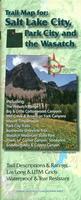
Waterproof! Salt Lake City & Park City Trail Map. Adventure Maps.
1:31,680. The Salt Lake/Park City, Utah Mountain Biking and Hiking Adventure Map is a waterproof, topographic map that includes a route guide and trail map covering trails throughout the Wasatch Range. It also includes detailed map and route descriptions for mountain bike trails, hiking trails, and horseback riding trails between North Salt Lake and Provo and a blowup up the extensive Park City Trail Network. Size is 27 x 39 inches.
Sample detail from the Salt Lake City Trail Map.
$12.99
62-9676-SLC
1 sheet, folded
Waterproof! St. George, Hurricane & Springdale Trail Map. Adventure Maps.
1:55,000. The St George/Springdale Adventure Map & Guide is a waterproof, topographic map that includes a route guide covering trails throughout Gooseberry Mesa, Little Creek Mesa, the Red Cliffs Desert Reserve, Snow Canyon State Park, Zion National Park and the Pine Valley Mountain Wilderness. Size is 27 x 39 inches.
Sample detail from the St. George Trail Map. Thumbnail image of the front of the St. George Trail Map.
$11.99
62-9676-STG
1 sheet, folded
Hiking the Wasatch map - The Official Wasatch Mountain Club Trail Map for the Tri-Canyon Area. University of Utah Press.
1:24,000. Waterproof hiking map of the area with hiking trails and distances added.
$14.95
62-9674
1 sheet, folded.
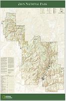
Zion National Park Wall Map. National Geographic Maps.
$16.99
62-9675Z
1 sheet flat/rolled
$26.99
62-9675ZL
Laminated.
Waterproof! Recommended! Utah Region. National Geographic Maps.
These waterproof topographic/hiking maps typically cover an area of four 7-1/2 minute quadrangles. These are very detailed, updated frequently, and include trail, campground, and other outdoor recreation activity information.
Cedar Mountain/Ashdown Gorge/Dixie National Forest. 1:48,000. #702.
$14.95
63-2100-703
Dark Canyon/Natural Bridges. 1:90,000. #703.
$14.95
63-2100-710
Escalante Canyons. 1:70,500. #710.
$14.95
63-2100-704
Flaming Gorge/East Uintas. 1:90,000. #704.
$14.95
63-2100-706
Grand Gulch. 1:62,500. #706.
$14.95
63-2100-711
High Uintas. 1:75,000. #711.
$14.95
63-2100-708
Paiute ATV Trail. 1:90,000. #708.
$14.95
63-2100-712
San Rafael Swell. 1:90,000.
$14.95
63-2100-701
Timpanogos/Lone Peak/Nebo. 1:48,000. #701.
$14.95
63-2100-709
Wasatch Front/Strawberry Valley. 1:90,000. #709.
Waterproof Capitol Reef National Park Topographic/Hiking Maps. Trails Illustrated/National Geographic Maps. These waterproof maps cover the Capitol Reef National Park in south-central Utah. The maps have detailed topographic information as well as hiking trails, campgrounds, and other back-country information. One map covers
Sample detail of the Capitol Reef Map
$14.95
63-2100-707
Fish Lake/Central Capitol Reef hiking map. 1:90,000. #707. 1995.
$14.95
63-2100-267
Capitol Reef National Park hiking map. 1:75,000. #267. 2013.
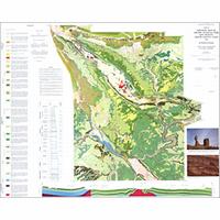
Geologic Map of Capitol Reef National Park. Utah Division of Natural Resources. 1:62,500. 1987.
This map covers the geology of Capitol Reef National Park. Information in this publication includes: two cross-sections, a correlation of map units, a lithologic column, and a description of map units.
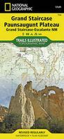
Grand Staircase, Paunsaugunt Plateau, Grand Staircase - Escalante National Monument. 1:75,000. Trails Illustrated #714. This map includes Willis Canyon in Bryce Canyon National Park, Kodachrome Basin State Park, Bryce Canyon National Park, Grosvenor Arch, and a portion of the Great Western Trail. Cottonwood Canyon backcountry byway, Highway 12 Scenic Byway, and Paunsaugunt Plateau, a popular ATV area, are also included. This uniquely detailed map includes trail mileages, wilderness study areas and clearly identifies 4wd roads.
$14.95
63-2100-859
Paria Canyon, Kanab, Vermilion Cliffs National Monument, Grand Staircase - Escalante National Monument. 1:75,000. Trails Illustrated #859. This map features Vermillion Cliffs National Monument, Paria Canyon Vermillion Cliffs Wilderness, Jacob Lake and Lees Ferry Recreation Areas and portions of the Great Western Trails in Utah and Arizona. Hog Canyon OHV Trail System and Fredonia-Vermillion Cliffs Scenic Byway are also included.
Waterproof! Utah National Park Topographic Maps. US Geological Survey.
$12.95
62-9675A
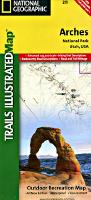
Arches National Park map. 1:50,000. (USGS).
$12.99
62-9675B
Bryce Canyon National Park map. Shaded Relief Map. 1:50,000. (USGS).
$12.95
62-9675C
Bryce Canyon National Park map. Topographic Map. 1:31,680. (USGS).
$12.95
62-9675F
Cedar Breaks National Park map. 1:15,840. (USGS).
$12.95
62-9675G
Dinosaur National Monument map. 1:62,500. (USGS).
Utah Wall Maps.
Utah State and County Wall Maps. Intelligent Direct.
We offer state and county wall maps for all of the USA. The maps come in sizes from 24 x 36 to 108 x 144 inches. They are available in variety of mounting and framing options. The maps are ideal for business applications, sales territory, delivery planning, direct mail targeting and hundreds of other applications.
Click here to order county wall maps and to see sample images, descriptions, and prices.
Click here to order state wall maps and to see sample images, descriptions, and prices.
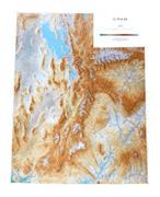
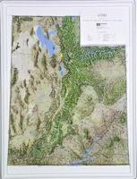
Utah Shaded Relief Wall Map. Raven Press.
1:500,000. From lofty, snow-covered mountains to exquisite rock formations and dramatically colored canyons, Utah is a beautiful state. The Uinta Range in the northeast is the only Rocky Mountain range that runs east west. The Beehive State is also know for the Great Salt Lake, the Bonneville Salt Flats, Bryce Canyon, the Wasatch Range, Zion Canyon, the Colorado River, and Lake Powell. Elevations are represented by color, and this, in combination with our relief shading technique, gives the map a 3-dimensional look. Size is 41 x 50".
Thumbnail of the map. Sample of the detail.
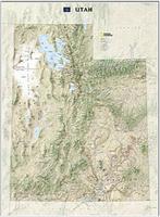
Utah Wall Map. National Geographic Maps.
1:705,645. Utah's diverse terrain and vegetation is rendered accurately through the map's color palate, shaded relief, and ocean bathymetry. Inherent to National Geographic reference cartography, the state wall maps contain thousands of place names and precise locations of: cities, major roadways and railways, airports, federal and state protected lands, mountain ranges and prominent peaks, marine sanctuaries, military installations, major lakes, rivers and reservoirs, and other geographic features. Map size is 41 x 31 inches, flat.
Thumbnail of the Utah wall map. Sample detail from the Utah Wall Map.
$19.99
62-9649
Each, rolled
$29.99
62-9649L
Laminated
Utah Topographic Map. USGS.
1:500,000. 1976. The official topographic map of Utah. Map size is 99 x 122 cm.
$12.95
62-9650
Utah Contoured topographic map.
$12.95
62-96501
Utah Shaded relief map.
$12.95
62-96502
Utah Base map.
$24.95
62-9650L
Utah Topographic map, laminated.
Arches National Park Satellite Poster. SatPrint.
This is a beautiful satellite poster, plotted on Kodak photo-paper. The poster includes names of many of the arches in the Park. Size is 24 x 36 inches.
Sample of the image detail. Thumbnail of the entire image.
$29.95
62-9679A
1 sheet, flat.
Great Salt Lake Landsat Image Map. USGS.
1:125,000. 1984. This sheet is compiled from Landsat imagery and illustrates the Great Salt Lake during winter. Map size is 86 x 130 cm.


 Sample detail from the Utah recreation atlas.

 Sample detail #1 from the Utah recreation map.
 Sample detail #2 from the Utah recreation map.
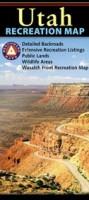
 Sample detail from the Utah recreation map.
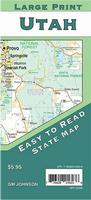
 Sample detail from the Utah large-print road map.
 Front of the Utah large-print road map.
 Reverse of the Utah large-print road map.
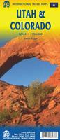
 Front of the Colorado and Utah travel map.
 Reverse of the Colorado and Utah travel map.
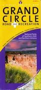
 Laminated
 Waterproof
 Sample detail from the Utah Destination map.
 Front of the Utah Destination map.
 Reverse of the Utah Destination map.
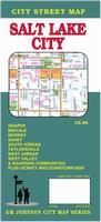

 Thumbnail image of the Salt Lake City wall map.
 Sample detail from the Salt Lake City wall map.
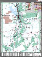 Utah County and State Wall Maps.


 Utah Raised Relief Maps.
 Waterproof!
 Sample detail from the Salt Lake City Trail Map.
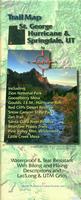 Waterproof!
 Sample detail from the St. George Trail Map.
 Thumbnail image of the front of the St. George Trail Map.
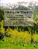
 Utah Hiking Map Index
  Sample of the Arches National Park map detail.
 Sample of the Flaming Gorge map detail.
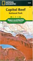 Waterproof
 Sample detail of the Capitol Reef Map
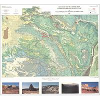
 Sample detail from the Grand Staircase hiking map.
 Front of the Grand Staircase hiking map.
 Reverse of the Grand Staircase hiking map.
 Sample detail from the Paria Canyon-Kanab hiking map.
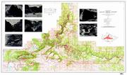 Waterproof!
 Thumbnail of the map.
 Sample of the detail.
 Thumbnail of the Utah wall map.
 Sample detail from the Utah Wall Map.
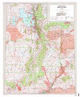 Utah Topographic Map. USGS.
 Sample of the image detail.
 Thumbnail of the entire image.
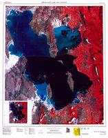
 Utah Flags