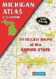
Michigan Atlas and Gazetteer. DeLorme.
1:150,000. Excellent road atlas with topographic maps, recreation information, and place-name gazetteer. Softcover, 120 pages.
$29.95
62-7448
Atlas
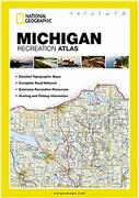
Michigan Recreation Atlas. National Geographic Maps.
1:175,000. National Geographic's Michigan Recreation Atlas is an ideal recreation resource and contains accurate, detailed topographic maps with private and public land boundaries, a complete road network, valuable recreation information and extensive cross-referenced lists and charts for campgrounds, lakes, parks, attractions and more. State Game Management Unit maps and fish species lists will appeal to the sportsman while detailed primary road networks will be of great interest to motorcyclists, RVers, and those simply touring the state.
Sample detail from the Michigan recreation atlas
Michigan Road Maps - Paper Maps
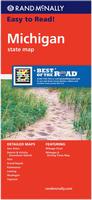
Michigan Road Map. Rand McNally.
A detailed road map of Michigan and the Upper Peninsula. The map has inset maps of Ann Arbor, Detroit & Vicinity, Downtown Detroit, Flint, Grand Rapids, Kalamazoo, Lansing, Muskegon, and Saginaw. Map size is 28 x 40 inches unfolded.
$7.99
62-7490
1 sheet, folded
Michigan Road Map. Universal Map.
The Michigan fold map is a full-color, regional map, including: Battle Creek, Detroit, Flint, Grand Haven, Grand Rapids, Isle Royale National Park, Jackson, Kalamazoo, Lansing, Saginaw, Sault Ste. Marie, and Traverse City.
$6.99
62-74904
1 sheet, folded.
Michigan Breweries & Wineries Map. Kappa Map Group. 2017.
This guide includes a comprehensive directory of over 200 brewery locations and over 100 of the state's winery locations. the map includes insets covering fourteen urban areas.
Sample detail of the map
$7.99
62-74908
1 sheet, folded.
Great Lakes Travel Map. 1:1,000,000. ITMB.
Using this map, one can explore Lakes Ontario and Erie as circular routes; also Huron and Superior; visit Ottawa and Toronto, Chicago and Duluth, and find Fort WilliamWawa Goose. This is a double-sided map covering from Ottawa in the north to Pittsburgh and Columbus in the south and Duluth and Thunder Bay in the west. Both Canada and the USA portions of the Great Lakes Region are included.
Sample detail of the Great Lakes Travel Map
$9.95
62-20913-GL
1 sheet, folded.
$24.99
62-20913-GLW
1 sheet, flat.
$34.99
62-20913-GLL
1 sheet, laminated.
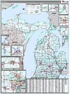
Michigan Regional Maps. GM Johnson.
This is an eleven-sheet detailed road map set giving complete coverage of Michigan. The maps highlight the backroads, lakes, and small towns throughout the state. Each map is approximately 27 x 38 inches unfolded.
$5.95
62-74905-CA
Michigan's Capital Area road map. Includes enlargements of downtown Lansing, Michigan State Univ., Belding, Bellevue, and 19 adjoingin towns. 2010.
$5.95
62-74905-CE
Michigan Central road map. Includes enlargements of Alma, Big Rapids, Breckenridge, Canadian Lakes, Clare, and 12 other towns. 2010.
$5.95
62-74905-MW
Michigan Midwest road map. Includes enlargements of Allegan, Caledonia, Cedar Springs, Fennfille, Fremont, Grand Haven and 14 other towns. 2010.
$5.95
62-74905-NH
Michigan's Northern Highlands road map. Includes enlargements of Grayling, Greenbush, Harrisville, Higgins Lake, Houghton Lake, 16 additional towns. 2010.
$5.95
62-74905-NO
Michigan's Northern Tip regional map.
$6.95
62-74905-NW
Michigan Northwest road map. Includes enlargements of Arcadia, Baldwin, Bear Lake, Cadillac, Copemish, Traverse City and 13 adjoinging towns. 2010.
$5.95
62-74905-SA
Michigan's Saginaw Valley road map. Includes enlargements of Au Gres, Beaverton, Birch Run, Bridgeport, downtown Saginaw, downtown Flint, and 14 adjoining towns. 2010.
$5.95
62-74905-SC
Michigan South-Central road map. Includes englargements of Adrian, Albion, Blissfield, Clinton, Coldwater, and 7 adjoining towns. 2010.
$6.95
62-74905-SW
Michigan Southwest road map. Includes enlargements o Bangor, Benton Hrbor, Berrien Springs, Bridgman, Buchanan, and 21 adjoining towns. 2010.
$5.95
62-74905-TH
Michigan's Thumb road map. Includes enlargements for Algonac, Almont, Bad Axe, Caro, Caseville, Cass City, Sandusky, and 13 adjoining towns. 2010.
$5.95
62-74905-UP
Michigan's Upper Peninsula regional map.
Michigan Road Maps - Laminated Maps
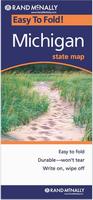
Michigan Easy-to-Fold™ Laminated Road Map. Rand McNally.
The durable and convenient Michigan EasyToFold state map will take all the wear and tear your journey can dish out. The heavy-duty laminated design allows you to mark your route, make notes, then wipe the surface clean for further use. Map size is 18 x 17 inches unfolded, ideal for use in a car.
$9.99
62-74902
1 sheet, folded
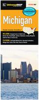
Michigan Road Map. Universal Map.
This map of Michigan State is durably laminated and contains extensive coverage. Laminated maps are easy to fold, write on, and wipe off. Coverage includes enlarged insets of: Battle Creek, Detroit, Flint, Grand Rapids, Jackson, Kalamazoo, Lansing, Marquette, Sault Ste. Mare, and Traverse City; and features: Isle Royale National Park, Interstate Exit Numbers, a Mileage Chart, Parks and Rec Areas, and Places of Interest.
$9.99
62-74906
1 sheet, folded.
Michigan City Maps - Paper Maps
Michigan City Maps - Paper Maps. Various publishers.
$6.95
63-1550
University of Michigan at Ann Arbor. (Hedberg).
$5.99
62-7492A
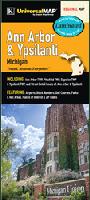
Ann Arbor/Brighton/Howell Map. (Rand McNally).
$6.95
62-7492ANN
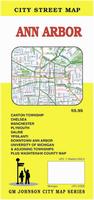
Ann Arbor Street Map. (GM Johnson).
$5.95
62-7492BAT
Battle Creek & Jackson City Map. (GM Johnson).
$5.95
62-7492BR
Brighton city map. (GM Johnson). Includes Howell, and Livingston County.
$5.95
62-7492CAP
Capital City area map. (Universal).
$6.99
62-7492DD
Detroit & SE Michigan street map. (Rand McNally).
$7.99
62-7492DE
Greater Detroit street map. (Universal Map).
$5.95
62-7492FLI
Flint Street Map. (GM Johnson).
$7.99
62-7492GRA
Grand Rapids city map. (Universal).
$6.95
62-7492GRR
Grand Rapids city map. (GM Johnson).
62-7492BAT
Jackson & Battle Creek city map - 62-7492BAT Battle Creek above.
$6.95
62-7492KAL
Kalamazoo city map. (GM Johnson). Includes Augusta, Galesburg, Portage, Richland, Shoolcraft, and adjoining communities.
$5.95
62-7492LA
Lansing city map. (GM Johnson).
$4.95
62-7492MA
Mackinac Island street map. (GM Johnson). Includes Saint Ignace, Cheboygan.
$5.95
62-7492MACO
Macomb County street map. (GM Johnson).
$5.95
62-7492MB
Macomb City Map. (Universal Map). Now out of print - limited stock left.
$5.95
62-7492MID
Midland & Mt. Pleasant city map. (GM Johnson).
$4.95
62-7492MO
Monroe County street map. (GM Johnson). Includes Bedford twp., Carleton, Dundee, Luna Pier, and adjoining towns.
$5.95
62-7492MUS
Muskegon city map. (GM Johnson). Includes Saugatuck, Zeeland, Norton Shores, Spring Lake, and adjoining towns.
$4.95
62-7492MU
Muskegon/Grand Haven City Map. (Rand McNally).
$6.95
62-7492OKN
Oakland County North street map. (GM Johnson).
$5.95
62-7492OKS
Oakland County South street map. (GM Johnson).
$6.95
62-7492PP
Port Huron and Saint Clair County street map. (GM Johnson).
$5.95
62-7492SA
Saginaw City Map. (GM Johnson).
$6.99
62-7492SB
Saginaw Valley Map. (GM Johnson).
$5.99
62-7492TR
Traverse City street map. (Universal Map). Now out of print - limited stock left.
$5.95
62-7492TRA
Traverse City street map. (GM Johnson).
$6.95
63-1550
University of Michigan at Ann Arbor map. (Hedberg).
$4.95
62-7492UP
Upper Peninsula City Map. (Rand McNally).
$5.95
62-7492UPP
Upper Peninsula City Map. (GM Johnson).
$7.99
62-7492UR
Upper Peninsula City Map. (Universal Map).
Michigan City Maps - Laminated Maps
$8.99
62-74921AN
Ann Arbor Laminated Map. (Universal Map).
$8.95
62-74921LAN
Lansing Laminated Map. (Universal Map). Now out of print - limited stock left.
Michigan City Street Atlases
$29.99
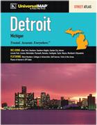
62-74922DA
Detroit Street Atlas. (Universal Map). The Detroit, MI Atlas is a full-color street atlas, including: Allen Park, Dearborn, Dearborn Heights, Garden City, Inkster, Lincoln Park, Livonia, Melvindale, Plymouth, Romulus, Southgate, Taylor, Wayne, Westland, and Wyandotte; and features: Block Numbers, Colleges and Universities, Golf Courses, Parks and Rec Areas, Places of Interest, and ZIP Codes. Now out of print - limited stock left.
$21.99
62-74922GR
Grand Rapids Street Atlas. (Universal Map). The Grand Rapids, MI Atlas is a full-color street atlas, including: East Grand Rapids, Grandville, Kentwood, Walker, and Wyoming; and features: Airports, Block Numbers, Colleges and Universities, Golf Courses, Government Buildings, Interstate Exit Numbers, Parks and Rec Areas, Places of Interest, Schools, and ZIP Codes. Now out of print - limited stock left.
Michigan City Wall Maps
Michigan City Wall Maps.
When it comes to general planning, defining delivery areas, planning direct marketing and delivering products, our city wall maps are perfect to get the detailed information you need.
These maps offer clear mapping by showing all major streets and roads and many of the smaller streets, but leaving out the smallest streets. If you want a clear map for easy planning, then these are the maps for you; if you want a map showing every little back alley, these are not for you.
We offer wall maps for Ann Arbor, Battle Creek, Canton, Dearborn, Dearborn Heights, Detroit, East Lansing, Farmington Hills, Flint, Grand Rapids, Jackson, Kalamazoo, Kentwood,
Lansing, Livonia, Novi, Pontiac, Redford, Rochester Hills, Royal Oak, Saginaw, Southfield, St. Clair Shores, Sterling Heights, Taylor, Troy, Warren, Waterford, West Bloomfield, Westland, and Wyoming.
Click here to order and to see sample images, prices, sizes, and mounting options.
Michigan Bicycling Maps. There is one popular long-distance trail in Michigan - the North Lakes Trail that crosses Michigan and the Upper Peninsula. There are two shorter trails - the Lake Erie Connector Route and the Detroit Alternative Route. We also stock the single-sheet cycling map for the entire state.
Click here for 1:250,000 sectional raised relief maps.
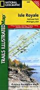
Waterproof! Isle Royal Hiking Map. 1:63,000. Trails Illustrated/National Geographic Maps #240. Detailed topographic hiking/canoe map showing trails, beaches, scenic view, campgrounds, and much more. Printed on waterproof, tear-resistant synthetic paper.
$14.95
63-2100-240
1 sheet, folded.
Michigan Wall Maps
Michigan State and County Wall Maps. Intelligent Direct.
We offer state and county wall maps for all of the USA. The maps come in sizes from 24 x 36 to 108 x 144 inches. They are available in variety of mounting and framing options. The maps are ideal for business applications, sales territory, delivery planning, direct mail targeting and hundreds of other applications.
Thumbnail image of the Michigan wall map Sample detail from the Michigan wall map
Click here to order county wall maps and to see sample images, descriptions, and prices.
Click here to order state wall maps and to see sample images, descriptions, and prices.


 Sample detail from the Michigan recreation atlas

 Sample detail of the map
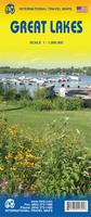
 Sample detail of the Great Lakes Travel Map
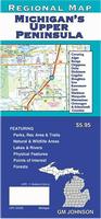

 Sample detail from the Ann Arbor wall map.

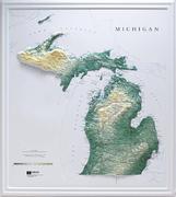 Michigan Raised Relief Maps.
 Waterproof!

 Thumbnail image of the Michigan wall map
 Sample detail from the Michigan wall map
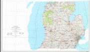 Michigan Topographic Map. USGS.
 Sample detail from the Michigan topographic map.
 Image of the Michigan topographic map.
 Michigan Flags