Contact information. Includes contact e-mails, telephone and fax numbers, and mailing address.
DeLorme Atlas & Gazetteers
DeLorme Atlases - new editions. These topographic atlases cover individual states with the most comprehensive detail available, including back roads, backwater lakes and streams, boat ramps, forests, wetlands, trailheads, campgrounds, public lands, prime hunting and fishing spots, and countless landmarks and points of interest. You ll also find a wealth of information on everything from family outings to wilderness adventures. The Atlas & Gazetteer is ideal for outdoor recreation, business travel, home or office reference, and countless other uses.
$24.95
62-6148
Florida Atlas & Gazetteer. 2016. ISBN 9780899333991.
$29.95
62-6748
Iowa Atlas & Gazetteer. 2017. ISBN 9781946494009.
$29.95
62-7548
Minnesota Atlas & Gazetteer. 2016. ISBN 9780899333335.
$24.95
62-7748
Missouri Atlas & Gazetteer. 2016. ISBN 9780899334493.
$29.95
62-8348
New Mexico Atlas & Gazetteer. 2016. ISBN 9780899334479.
$29.95
62-8548
North Carolina Atlas & Gazetteer. 2016. ISBN 9780899334455.
$29.95
62-8648
North Dakota Atlas & Gazetteer. 2016. ISBN 9780899334462.
$29.95
62-9048
Pennsylvania Atlas & Gazetteer. 2016. ISBN 9780899334431.
$29.95
62-9548
Texas Atlas & Gazetteer. 2016. ISBN 9781946494016.
$29.95
62-9648
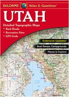
Utah Atlas & Gazetteer. 2017. ISBN 9780899334486.
$29.95
62-9948
Washington Atlas & Gazetteer. 2016. ISBN 9780899333298.
Kappa Map Group New Maps and New Editions
Kappa Map Group Atlases - new editions.
$25.99
62-6292AU
Atlanta Metro Street Atlas. ADC. Size 8.5 x 11", Spiral-bound. ISBN 9780762587988.
$21.99
62-90921CH
Chester County, Pennsylvania Street Atlas. ADC. Size 10.25 x 13.25", Spiral-bound. ISBN 0762591331.
$18.99
62-7292HA
Harford County, Maryland Street Atlas. ADC. ISBN 9780762589241. Limited stock.
$24.99
62-90921LA
Lancaster County, Pennsylvania Street Atlas. ADC. Size 10.25 x 13.25", spiral-bound. ISBN 076259117X.
$18.99
62-9890LO
Loudoun County, Virginia Street Atlas. ADC. Size 10.25 x 13.25", soft-cover. ISBN 0762591250.
$22.99
62-7292MO
Montgomery County, Maryland Street Atlas. ADC. Size 10.25 x 13.25", spiral-bound. ISBN 9780762589685.
$19.99
62-84922NA
Nassau County, New York Street Atlas. Hagstrom. Size 8.5 x 11", soft-cover. ISBN 0762585145.
$26.99
62-84922SU
Suffolk County, New York Street Atlas. Hagstrom. Size 10.875 x 14", spiral-bound. ISBN 0762591277.
Kappa Map Group Maps - new editions.
$9.99
62-76902
Alabama & Mississippi Road Map - waterproof. ISBN 9780762587971.
$9.99
62-55903
Arkansas & Louisiana Road Map - waterproof. ISBN 9780762585984.
$9.99
62-77904
Missouri Road Map - waterproof. ISBN 9780762587926.
$9.99
62-88903
Oklahoma Road Map - waterproof. ISBN 9780762586301.
$6.99
62-9592HILC
Texas Hill Country Road Map - paper. ISBN 9780762590247.
(AK) Tongass National Forest - Baranof Island, Sitka Ranger District . 1:168,960. 2016. Waterproof, with contour lines at 500 feet. ISBN 9781593519438.
$14.99
62-53791
(AK) Tongass National Forest - Petersburg Ranger District Map. 1:168,960. 2016. Waterproof, with contour lines at 500 feet. ISBN 9781593519445.
$19.99
62-76781
(MS) Delta and Homochitto National Forests Map. 1:126,720. 2016. This map covers the southern portion of the Cherokee National Forest. Waterproof, without contour lines. ISBN 9781593516734.
$15.99
62-80789
(NV) Humboldtl-Toiyabe National Forests - Carson Ranger District Map. 1:126,720. 2017. Waterproof, with contour lines. ISBN 9781593513993.
$15.99
62-89886
Oregon Outback Map. 1:126,720. 2016. The map covers an area in south-central Oregon, from Deschutes County south to the OR-CA border. Waterproof, without contour lines. ISBN 9781628115628.
$15.99
62-89885
(OR) Siuslaw National Forest - Hebo Ranger District Map. 1:63,360. 2015. Waterproof, with contour lines. ISBN 9781628115536.
$15.99
62-89859
(OR) Umpqua National Forest - Tiller Ranger District Map. 1:63,360. 2017. Waterproof, with contour lines. ISBN 9781628115680.
$19.99
62-94780
(TN) Cherokee National Forest (North) - Watauga and Unaka Ranger Districts Map. 1:63,360. 2016. This map covers the northern portion of the Cherokee National Forest. Waterproof, with contour lines. ISBN 9781593516987.
$19.99
62-94781
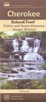
(TN) Cherokee National Forest (South) - Tellico and Ocoee-Hiwassee Ranger Districts Map. 1:63,360. 2016. This map covers the southern portion of the Cherokee National Forest. Waterproof, with contour lines. ISBN 9781593516994.
$19.99
62-99799
(WA) Olympic National Forest - Hood Canal Ranger District Msp. 1:63,360. 2017. Waterproof, with contour lines. ISBN 9781593515904.
$19.99
63-02796
(WY) Medicine Bow National Forest - Sierra Madre Range, Brush Creek - Hayden Ranger District Msp. 1:63,360. 2016. Waterproof, without contour lines. ISBN 9781593511395.
Tonto National Forest Atlas. 1:24,000 maps reduced to 1:63,360 scale. 2016. Spiral-bound, with contour lines. ISBN 9781628112092.
France Maps
Battle of the Somme 1916 Map. 1:75,000. France IGN, 2016.
Commemorative map published by the French IGN for the anniversary of the Battle of the Somme. The map shows the front lines from July 1st, 2016 to November 30th, 1916 and shows the access points to present day remains, monuments and the numerous war cemeteries.
The main map at 1:75,000 shows the area covered by the British Third Army and the French Seventh Army and the dispositions of individual Corps and Divisions, with similar information but in less detail for the German forces. Symbols indicate locations of remains of the military fortifications, war memorials, cemeteries, etc.
A large panel at 1:35,000 shows in greater detail main area of the Battle of the Somme between Albert and Bapaume, along the front line from Hébuterne in the north, across Beaumont-Hamel and Thiepval, to the Somme.
Battle of the Aisne (Chemin des Dames) 1917 Map. 1:75,000. France IGN, 2016.
Commemorative map published by the French IGN for the anniversary of the "Battle of the Chemin des Dames 1917" with this 1:75,000 scale map. It presents the front lines, memorial sites (memorials, military cemeteries, old defensive works, museums).
Legend in English, French, German. ISBN 9782758538479.
$15.99
64-56923
1 sheet, folded.
Battle of Verdun (Bataille de Verdun) 1916 Map. 1:75,000. France IGN, 2016.
Commemorative map published by the IGN for the anniversary of the Battle of Verdun showing the front lines from February 21 to December 18, 1916, La Voie Sacrée, plus present day remains, monuments and war cemeteries.
The main map at 1:75,000 shows the area covered by the British Third Army and the French Seventh Army and the dispositions of individual Corps and Divisions, with similar information but in less detail for the German forces. Symbols indicate locations of remains of the military fortifications, war memorials, cemeteries, etc.
A large inset map at 1:35,000 1:35,000 shows in greater detail the Forest of Verdun.
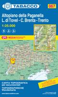
Altopiano della Paganella, L. di Tovel, C. Brenta, Trento hiking map. 1:25,000. Tabacco, Italy, 2017. ISBN 9788883151132.
$15.99
64-8275-67
1 sheet, folded.
Parco naturale Dolomiti Friulane hiking map. 1:25,000. Tabacco, Italy, 2017. ISBN 9788883151163.
$13.99
64-82752-DF
1 sheet, folded.
Visiting North Carolina? Like to visit Omni? Please click here for a Mapquest map to our offices. If you are passing through central North Carolina, we would be pleased to have you visit our store and warehouse. We are located about 30 minutes east of Greensboro, 60 minutes west of Raleigh, and 2 hours northeast of Charlotte. We are open Monday-Friday 8am - 5:30pm and weekends by prior arrangement.
Contact information: For information on a map or other product: [email protected] To place an order or check on an order: [email protected] For questions on an invoice: [email protected] Phone: (1) 800-742-2677 (USA) or (1) 336-227-8300 (International)
Fax: (1) 336-227-3748


 Sample detail from the Hood Canal Ranger District map
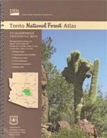
 Sample detail from the Tonto National Forest atlas
 Sample detail from the Battle of the Somme map

 Sample detail from the Battle of Verdun map