We stock a huge selection of World Maps, from room-sized wall maps to specialty maps such as World Upside Down maps. Please click on the links below to see our complete list of World Maps.
Click here to see our listings of map pins, map tacks, and transparent map dots, all for use with wall maps.
World Wall Maps by National Geographic
Our favorite two world maps
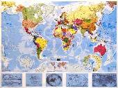
World Maps - Decorator style.Colorful and bold - countries easily identified. Enjoy the accuracy and beauty of the latest world map from the cartographers at National Geographic. This map features the Winkel Tripel projection. The Decorator map has spectacular color and detail to bring the world alive. Ideal for home, office, or school.
Thumbnail of the entire map Sample map detail #1 Sample map detail #2 An enlarged view of the mounted map
Small Size - paper and/or laminated
$16.99
67-10536
World Political Map, Winkel projection. 1:38,931,000. 46 x 30".
$29.95
67-10536L
World Political Map, laminated.
Large Size - paper and/or laminated
$34.99
67-10537
World Political Map, Winkel projection - large size. 1:24,000,000. 73 x 48".
$59.99
67-10537L
World Political Map - large size, laminated.
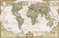
World Maps - Executive Style (Antique style).Current information with an old look. Enjoy the accuracy and beauty of the latest world map from the cartographers at National Geographic. This map features the Winkel Tripel projection and has elegant, rich tones that will complement any office or home. Astounding detail and board room quality make these maps excellent for reference or as a keepsake for your map library. This is a current political map featuring an antique style. 43'' x 30''.
Winner of the 2001 Premier Print Award from Printing Industries of America for "a unique ability to create visual masterpieces"
World Political Map, Winkel projection. 1:38,931,000. 46 x 30".
$24.99
67-10538L
World Political Map - small size, laminated. 46 x 30".
Large Size - paper and laminated
$34.99
67-10539
World Political Map, large size. 1:24,000,000. 70 x 49".
$59.99
67-10539L
World Political Map - large size, laminated. 73 x 48".
Wall Mural Size - paper
$99.99
67-10539M
World Political Map - wall mural size. 116 x 76"
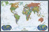
Classic National Geographic World Map! World Political Map. This famous map features the Robinson projection, which minimizes distortion relative to shapes, distances and perspective. Insets of physical hemispheres, polar views, vegetation and land use, and population density. Available in three sizes.
Small size - 40-1/2" x 27-1/4". Huge size - 71-1/4" x 50". Mural size - 110" x 76" (9' 2" x 6' 4"). An image of the full map A detail of the map A sample of the legend An enlarged view of the mounted map
Small Size - paper and laminated
$14.99
67-10530
Small size - 40-1/2" x 27-1/4". Rolled.
$24.99
67-10530L
Small size - laminated.
Large Size - paper and laminated
$34.99
67-10531
Large size - 71-1/4" x 50".
$59.99
67-10531L
Large size - laminated.
Wall Mural Size - wall paper
$99.99
67-10532
Mural size - 110" x 76" (9' 2" x 6' 4"). 1:15,267,000. This supersized panorama comes boxed in three sections and hangs like wallpaper. Printed on latex-coated paper stock.
World Hemispheres Map. National Geographic Maps, 2007. During the 1930's and 1940's, several National Geographic world maps were designed using a projection that separated the eastern and western hemispheres. NGS have brought back this classic view of the world with updated, modern cartography and an elegant earth-tone color palette. This new, yet fashionably retro, world map is the World Hemispheres Map.
Thumbnail image of the entire map Sample of the map detail
$12.99
67-10529
1 sheet, flat.
$24.99
67-10529L
Laminated.
World Explorer Map. Enjoy the accuracy and beauty of the latest world map from the cartographers at National Geographic. Map features Winkel Triple projection to reduce distortion of land masses as they near the poles. Features include charts listing largest cities by population and the largest countries in the world by land mass and population.
$5.99
67-10540
World Explorer Map, folded. 32 x 20".
$9.99
67-10541
World Explorer Map, flat/rolled. 32 x 20".
Maps of Discovery - East & West mounted set. National Geographic Maps. In 1927, famed American painter N.C. Wyeth completed a series of five murals for Hubbard Memorial Hall, the National Geographic Society's first formal library. Called "The Romance of Discovery," the murals were flanked by highly illustrated maps of the eastern and western hemispheres showing the paths taken by some of the world's most significant explorers. The eastern hemisphere map is decorated with portraits of these men charting their courses. The western hemisphere features Poseidon and a mermaid keeping watch over the oceans. These two murals have been captured on paper for everyone to enjoy.
Each plaque measures 20" x 18". Available as an east + west set mounted on wood, or as individual east or west maps, either plain paper, or laminated.
An image of the full map A detail of the map
$16.99
67-10505E
Eastern hemisphere, flat/rolled
$33.99
67-10505EL
Eastern hemisphere, laminated
$16.99
67-10505W
Western hemisphere, flat/rolled
$33.99
67-10505WL
Western hemisphere, laminated
Flexible Magnetic World Political Maps
Flexible Magnetic World Political Wall Maps. Futuremapping, UK.
These very attractive equal-area maps are laminated and mounted on flexible sheet metal so that the maps can be rolled and stored in a tube.
Each map has a safe, durable, write/on wipe off surface that magnets will stick to.
The maps can be easily fixed to a wall using two magnetic strips along the top and bottom of the maps (included with each map).
Each map comes with a dozen magnetic dots.
Each map also available as a laminated-only (not magnetic) version, or a simple paper version.
The map uses a cylindrical equal area projection that represents countries in their correct proportional size. It achieves this by sacrificing shape, particularly in the areas closest to the poles. The result is an alternative and thought-provoking vision of the planet on which we live.
The attractive color palette flows through countries and continents removing the abrupt country border lines of more traditional lines. This gives a soothing appeal to this map without sacrificing accuracy or information.
Details include: political boundaries, capital and major cities, rivers, highest peaks, sea depths, North and South Pole projections and a shaded physical relief layer.
Futuremap's Huge World Political Wall Map. 1:40,000,000. Futuremapping, UK.
Color is Emerald to Lime to Metallic Khaki. Size is 40 x 23".
Mural size - 78-1/2 x 39-1/4" (2 x 1 meters). Blue to emerald to pink to yellow.
$119.99
67-1068
Paper only.
ColourMap - Small size - 51" x 28". 1:30,000,000.
$139.99
67-10689M
Blue to emerald to pink to yellow: Magnetic.
Futuremap World Political wall map - Mint to orange to khaki. Size is 36 x 20 inches. We have limited inventory left in this color palette, which is being replaced by 67-106811 below.
Futuremap World Political wall map - Aqua to luminous red to gold. We have limited inventory left in this color palette, which is being replaced by 67-106811 above..
Futuremap World Political wall map - Blue to emerald to pink to yellow. With "checkerboard 1 x 1 degree grid on the ocean, giving the map a unique, attractive design-style.
World Political Wall Map - Colormap editions. 1:35,000,000. Futuremapping, UK. Are you looking for something different from the typical world political maps? These are beautiful, artistic world maps with a unique style ideal for a more modern setting. They are available as plain paper, laminated, or mounted on flexible magnetic backing.
Each country colored separately so the country borders are more apparent.
Map size is 120 x 62 cm (47 x 25").
Available in several color palettes - see below.
The oceans and seas are colored in 15° x 15° blocks, making it very easy to see latitude and longitude across the entire map.
Sea beds and plate tectonic boundaries and movements are also shown.
The map uses the Robinson Projection, a modified cylindrical equal area projection that represents countries in their correct proportional size. It achieves this by sacrificing shape, particularly in the areas closest to the poles. The result is an alternative and thought-provoking vision of the planet on which we live.
Details include: Country boundaries, capital and major cities, rivers, roads, and airports, time zones, and North and South Pole inset maps.
Maps are printed on a very high quality silk finish paper.
World Political Map, tyvek. 1:33,000,000. Interarts/Mapquest. A very colorful map, printed on waterproof and tear resistant tyvek(r). Ideal for thumbtacking to a wall as the thumbtacks don't tear out of the tyvek.
Sample of the map Thumbnail image of the map
$25.00
67-1105
Tyvek map, flat/rolled. Size is 28-1/2 x 50".
$39.99
67-1105L
Laminated, flat/rolled. Size is 29-1/2 x 53-1/2".
World "Megamap" Political Wall Map. 1:20,000,000. Maps International. A very colorful map, printed on paper. This large wall map is less cluttered and has larger type size than the comparable National Geographic maps, although the NG map has a little more detail. Size is approx. 48 x 77". Available in plain paper or laminated.
Sample of the World Megamap map detail. Thumbnail image of the World Megamap.
$54.99
67-1108
Paper map, flat/rolled.
$69.99
67-1108L
Laminated, flat/rolled.
World Political Wall Map with Flags, Blue Ocean. 1:30,000,000. Maps International. Maps International maps are highly detailed using crisp clear text, a vibrant color palette and attractive terrain shading. Perfect for home, office or classroom, this wall map of the World with Flags is informative and eye-catching. This edition features blue ocean coloring.
This World with Flags Wall Map features:
World Political Wall Map with Flags, White Ocean. 1:30,000,000. Maps International. Maps International maps are highly detailed using crisp clear text, a vibrant color palette and attractive terrain shading. Perfect for home, office or classroom, this wall map of the World with Flags is informative and eye-catching. This edition features off-white ocean coloring.
This World with Flags Wall Map features:
World Political Map, in French. 1:33,700,000. France IGN. A colorful political map that has relief shading to indicate the topography. Internal political boundaries are shown for India, Mexico, Canada, and the USA. Major rivers, towns and cities are marked. Examples of early world maps are illustrated along the bottom. In French. Aitoff-Wagner projection, in French. Size is 120 x 90 cm.
$19.99
67-10513
1 sheet, flat, rolled, paper.
$36.99
67-10513L
Laminated.
World Political Map, in Hungarian (Folded map). 1:36,000,000. Szarvas. A good quality folded world political map, in Hungarian.
 World Political Wall Maps
  World Physical Wall Maps
 World Political Wall Maps
 Thumbnail of the entire map
 Sample map detail #1
 Sample map detail #2
 An enlarged view of the mounted map
 Thumbnail of the map
 Sample detail from the map
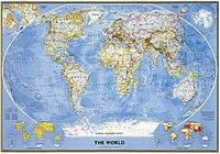
 An image of the full map
 A detail of the map
 A sample of the legend
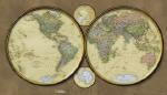
 Thumbnail image of the entire map
 Sample of the map detail
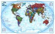


 An image of the full map
 A detail of the map
 Sample of the map detail
 Thumbnail image of the entire map
 Sample of the map detail
 Sample of the map detail
 Shows the map mounted on a wall
 Shows the map mounted on a wall
 Shows the flexibility of the map and the magnetic mounting strip
 Shows magnet use on the front of the map
 Sample #1 of the map detail
 Sample #2 of the map detail
 Thumbnail image of the entire map
 Sample #1 of the map detail
 Sample #2 of the map detail
 Thumbnail image of the entire map
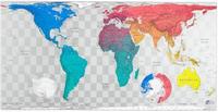
 Sample #1 of the map detail
 Sample #2 of the map detail
 Thumbnail image of the entire map
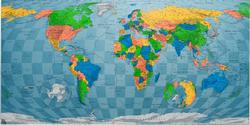
 Sample of the World Colormap map detail
 Thumbnail image of the entire World Colormap map
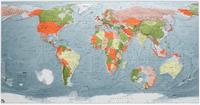
 Sample #1 of the World Colormap map detail
 Sample #2 of the World Colormap map detail
 Thumbnail image of the entire World Colormap map
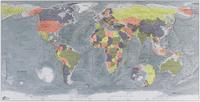
 Sample #1 of the World Colormap map detail
 Sample #2 of the World Colormap map detail
 Thumbnail image of the entire World Colormap map
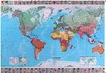
 Image of the entire map
 Sample of the map detail
 Sample of the map
 Thumbnail image of the map
 Sample of the World Megamap map detail.
 Thumbnail image of the World Megamap.
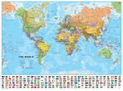
 Sample of the World political map detail.
 Sample of the World political map detail.
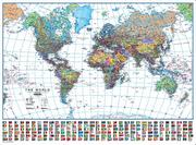
 Large thumbnail image of the World political map.