We stock a huge selection of World Maps, from room-sized wall maps to specialty maps such as World of Coffee maps. Click here to see our complete listing of World Maps.
Do you need map pins, map tacks, map pennants/flags to go with your world map? If so click here to see a complete list. Great marker pins, pennants, and flags for marking locations on maps. Multiple colors, multiple styles, numbered pins also available.
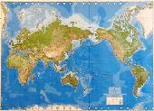
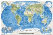
Recommended World Physical Map. 1:30,000,000. DMA/NIMA/USGS. An attractive large-sized world physical map that is reasonably up-to-date (lacking only the Zaire to Democratic Republic of Congo change). This is the updated single-sheet version of the 8-sheet World Wall Mural map (67-8805).
Updated 3-sheet and 6-sheet versions are also available. These maps are all made from the same original cartographic image, so the detail is the same on each map, just enlarged more for the larger wall maps. Please note that we have put sample images up for each size. Each sample is scanned at 1:1 and covers the same area of the map; the SE USA. This way you can see the comparable size and detail of the maps. Mercator projection.
8 sheets, rolled. Size 8.5 x 13.5 feet. Printed on wall paper for easy application.
$249.99
67-88051
8 sheets, rolled. Size 8.5 x 13.5 feet. "Executive" version with special coating to allow writing on the map with watersoluble markers. Printed on wall paper for easy application.
World Physical Map. 1:30,000,000. Kummerly + Frey. An attractive world physical map (the picture does not do the map justice). Shaded relief with oceans depths as well. Van der Grinten projection. Size is 33 x 51".
Sample of the detail of the map Thumbnail of the whole map
$19.99
67-10528
Paper map
$34.99
67-10528L
Laminated
World Physical Map. 1:27,400,000. Gabelli. Very popular with school teachers and the younger students - ocean depths clearly shown. Mercator projection.
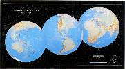
World Physical Map - Two Hemisphere View. Gabelli. Size is 25 x 40". Unique view showing two half-world views side-by-side, with two small polar views included. Now out of print, we have only two copies left.
$12.99
67-5907
Paper map, small 28 x 46"
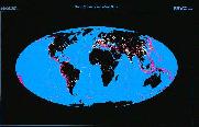
World Satellite Image Wall Maps
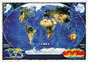
World Satellite Map. 1:39,000,000. National Geographic Maps
The most accurate map of Earth's surface yet produced from satellite data. This computer-generated composite map draws from more that 500 images to give one-kilometer detail and consistent representation of natural colors.
An enlarged view of the mounted map
$12.99
67-10542
World Satellite Image Map. 1:39,000,000. 44 x 30".
$24.99
67-10542L
World Satellite Image Map, laminated. 44 x 30".
$199.95
67-10542BL
World Satellite Image Map - mounted, black.
$199.95
67-10542GO
World Satellite Image Map - mounted, gold.
$199.95
67-10542WH
World Satellite Image Map - mounted, white.
$199.95
67-10542WO
World Satellite Image Map - mounted, wood-grain.
World As Seen from Space - World Satellite Image Map. Michelin.
The satellite photo map of the world, displaying the globe's bright colors ? a unique view of the earth which evokes a desire to explore the world. Laminated for durable use.
Thumbnail of the World Satellite Map.
$19.95
67-10543
1 sheet, rolled.
World Ocean Floor Wall Maps
World Ocean Floor Panorama. 1977. Heezen & Tharp. The map is based on more than 5,000,000 miles of soundings. This is the more subtle of the two ocean floor maps (67-3020 is the other) 96 x 61 cm (38 x 24").
The Atmosphere Chart. For the first time ever, here is a wall chart that depicts all of the major weather phenomena used by meteorologists, aviators and space scientists. The chart illustrates each weather system with a diagram and brief explanation. It shows spectacular color photographs of the basic cloud types, frontal systems, and more. Intended for students, hobbyists and professionals alike, The Atmosphere will prove invaluable as an easy wall reference. Size 55" x 33".
$17.95
71-5250
Each, rolled
$29.95
71-5250L
Each, laminated
World Environment Maps
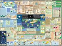
The Environment Chart. This attractive book-in-a-chart format will raise students' awareness of environmental hazards. 42 color photos illustrate the hazards of deforestation, toxic wastes, ozone depletion, oil spills, pollution, chemical accidents, severe weather, and more. Size is 55" x 33".
Detail of one of the inset maps. View of the entire chart.
$33.99
71-5290
Each
$29.95
71-5290L
Each, laminated
Clearance sale! World Atlas of Resources and Environment (Prioda i resursy Zemii). RAN, Vienna, 1998. This excellent atlas contains two volumes, divided into four major sections; I: The Earth and Space; II: Evolution of the Landscape Sphere; III: Landscape Sphere - Structure and Resources; IV: Anthropogenic Factors of Landscape Sphere Changes.
There are 190 thematic maps (1:6,000,000 to 1:300,000,000), many of which are fold-out maps. Each map sheet has comments on the reverse as well as graphs, tables, etc. In English with Russian titles. Size is 35 x 49 cm, clothbound with screws and slipcase.
$49.95
61-0800
Atlas.
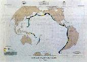
World Earthquake and Seismicity Maps
World Seismicity Poster: 1979-1988. USGS. This poster (64 x 36") displays selected hypocenters for earthquakes that occurred during 1979-1988.
More than 23,000 separate epicenter locations, representing 97,069 earthquakes, are displayed. The base map is Raven Maps' famous "Three Worlds" map.
$19.99
67-3208
Each, rolled
Global Seismicity and World Cities. USGS. This map (53 x 34.5") displays the worldwide hazard to cities posed by large earthquakes.
When earthquakes occur near cities of any size, the potential for damage is great. On this map more than 39,000 earthquake epicenters (purple dots) are depicted.
Where earthquake epicenters are co-located with cities, the earthquake epicenters are denoted by orange dots. Base map from Raven Maps.
$14.95
67-3205
Each, rolled
A Century of Great Earthquakes: 1897-1996. USGS. This map (27 x 18") sohws selected earthquakes having a determined magnitude of 7.8 or greater.
Portions of the Southwest and North Pacific are not included, even though they may have experienced great earthquakes. The base map is from Unique Media.
$14.95
67-3209
Each, rolled
Circum-Pacific Seismic Potential. USGS. The map (35 x 26") shows the time-dependent probabilities for the recurrence of large (7.07.7) shallow, plate-boundary earthquakes within specified segments of the Circum-Pacific region. The time window depicted is 1989-1999. Base map is from Raven Maps.
$14.95
67-3210
Each, rolled
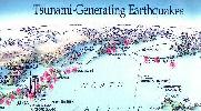
Tsunami-Generating Earthquakes. USGS. This map (27 x 18") shows those earthquakes that occurred in 1900-1994 that generated destructive tsunamis somewhere in the Pacific region.
Many of the earthquakes shown denerated tsunamis that resulted in loss of life. Tsunamis that originated from distant earthquakes are also shown on the map. Base map from Unique Media.
 Recommended
 World Physical map, full view.
 Image of Wall Mural map after mounting on wall.


 Sample of the detail of the blue-ocean map
 Thumbnail of the blue-ocean map
 Sample of the detail of the white-ocean map
 Thumbnail of the white-ocean map
 Sample of the detail of the map
 Thumbnail of the whole map
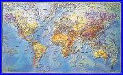

 Thumbnail image
 Sample detail
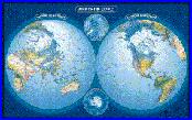


 An enlarged view of the mounted map
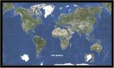
 Thumbnail of the World Satellite Map.
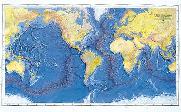 World Ocean Floor Panorama. 1977. Heezen & Tharp. The map is based on more than 5,000,000 miles of soundings. This is the more subtle of the two ocean floor maps (67-3020 is the other) 96 x 61 cm (38 x 24").

 An image of the full map
 A detail of the map
 A sample of the legend
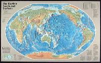
 An image of the full map
 A detail of the map
 A sample of the legend

 Detail of one of the inset maps.
 View of the entire chart.