Randonee Pyrenees 1:50,000 Topographic/Hiking Maps. 1:50,000. Randonee Pyrenees. These are excellent maps designed for the hiker, skier, and equestrienne. The maps utilize French and Spanish IGN 1:50,000 topographic maps as base maps, then add hiking, skiing, cycling and equestrian trails onto the maps. Sheets 1-11 cover the French side of the Pyrénées and sheets 20-25 cover the Spanish side of the Pyrénées. In French.
NOTE: Those sheets not listed below are out of print at the publisher at this time.
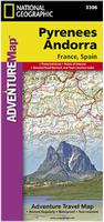
Waterproof! Pyrenees and Andorra Travel Map. Scale 1:275,000. National Geographic Maps.
The front side of the Pyrenees/Andorra map shows the country of Andorra and the eastern half of the Pyrenees including the cities of Narbonne, Carcassone, Pamiers, St-Gaudens, St-Girons, Perpignan in France, and Balaguer, Manresa, and Figueres in Spain. The reverse side of the map stretches from the city of Biarritz on the Bay of Biscay eastward to include Pamplona and Huesca, Spain, and Pau, Tarbes, and the famed pilgrimage site of Lourdes, France. This map is a wonderful companion for the Northern Spain AdventureMap (3306). Size is 26 x 38".
Sample detail of the Pyrenees travel map Front of the Pyrenees travel map Rear of the Pyrenees travel map
$11.99
64-56875
1 sheet, folded
Pyrenees Road Map. 1:400,000. France IGN.
This map replaces the old France IGN Pyrenees map at the same scale. This Rando Editions version covers the Pyrenees from coast to coast and with good coverage on both sides of the France - Spain border. Coverage extends from Auch, Toulouse and Béziers in France to Bilbao, Logrono, Zaragoza, Lleida and Barcelona in Spain; plus prominent highlighting of the regions national amd regional parks. The map does not have any geographic coordinates unfortunately. The map legend includes English, but the descriptive text is in French only. ISBN 9782344013403.
Sample detail from the Pyrenees map.
$14.99
64-56870
1 sheet, folded.
Pyrenees Road Maps. 1:200,000. France IGN.
These two maps offer excellent detail of the topography through contours and shaded relief, numerous names of topographic features, long-distance GR hiking routes, places of interest, etc. The maps have 100m contours, legends which include English, etc.
The eastern map offers coverage of the eastern part of the Pyrenees together with much of Languedoc-Roussillon region, extending along the coast to Montpellier and north to Toulouse. The overprint highlights both the GR10 and the GR 11 on the Spanish side. ISBN 9782758530497.
Walks & Climbs in the Pyrenees. By Kev Reynolds. Fully updated fifth edition of this classic guide, now in full colour, with redrawn map and new photos. Includes three new districts – Lac d'Oô and the Circque d'Espingo; Vallées de la Pique and du Lis; and Haute Vallée du Garbet – and several new routes.
The guide is an introduction to one of Europe's finest mountain ranges. It offers suggestions for 170 walks, multi day tours and moderate ascents of some of the principal summits of the Central or High Pyrenees.
The active walker, trekker and climber is spoilt for choice, for there is enough scope in the Pyrenees to fill a lifetime of holidays with a host of experiences no matter what your degree of commitment. There are exquisite valleys and passes to wander day after day, and summits of 3000 metres and more within the reach of most hill walkers. The landscape is full of diversity and contrast, with Alpine style peaks, small glaciers, deep gorges and more that a thousand mountain lakes. The range is also know as the 'flower garden of Europe', and the wildlife includes carious species rarely seen elsewhere on the continent.
Map showing area covered by the guide. Example of one of the trip maps from the guide.
$24.95
65-32961WP
Guide
Recommended Hiking Maps:
$19.99
64-5661-03
Sheet 3. Bearn. Parc National des Pyrenees hiking map.
$19.99
64-5661-04
Sheet 4. Bigorre. Parc Cantional des Pyrenees hiking map.
$19.99
64-5661-05
Sheet 5. Luchon. Aure - Louron Sud Comminges hiking map.
$19.99
64-5661-06
Sheet 6. Couserans - Cap d'Aran. Pallars - Parque Nacional d'Aigues Tortes hiking map.
France 1:25,000 topo #1546ET Laruns - Gourette hiking map.
$19.99
64-5648-1547OT
France 1:25,000 topo #1547OT Ossau - Vallée d'Aspe hiking map.
$19.99
64-5648-1647OT
France 1:25,000 topo #1647OT Vignemale hiking map.
$19.99
64-5648-1748OT
France 1:25,000 topo #1748OT Gavarnie - Luz-St-Sauveur hiking map.
$19.99
64-5648-1748ET
France 1:25,000 topo #1748ET Néouvielle - Vallée d'Aure hiking map.
$19.99
64-5648-2148OT
France 1:25,000 topo #2148OT Vicdessos hiking map.
$19.99
64-5648-2249ET
France 1:25,000 topo #2249ET Font-Romeu hiking map.
$19.99
64-5648-2249OT
France 1:25,000 topo #2249OT Bourg-Madame - Col de Puymorens hiking map.
Through the Spanish Pyrenees: GR11. By Paul Lucia. The Spanish Pyrenees present a wonderland to the holidaymaker, whether backpacker, botanist, canoeist, cyclist, entomologist, ornithologist, mountain biker, skier, walker or simply anyone with a love of mountain scenery. In recent years the mountain organisations and authorities in the administrative districts of Guipuzxoa, Navarra, Aragón, Andorra and Catalu&ntilda;a have got together with local villagers to arrange the waymarking of a coast to coast (Atlantic to Mediterranean) long-distance footpath through the Pyrenees on the Spanish side. Designated the Gran Recorrido 11, GR11 for short, it mirrors the French counterpart, the GR10. This has opened up miles of waymarked footpaths and tracks in an ever-changing environment, often in remote and high area, to numerous enthusiastic walkers of many nationalities, though the vastness swallows them up so that those seeking solitude will also not be disappointed.
The GR11 is now a truly high quality, high-level mountain trail, affectionately known as 'La Senda' (The Track). A combination of spectacular high peaks, glistening tarns, deep green valleys and expanses of wild beauty as yet unseen by many visitors make the range an excellent choice for the adventurous walker – in addition to a moderate climate and easy access.
Index showing the route covered. Sample of a daily hiking map in the guide.


 Index for Randonee Pyrenees series - click here.
 Map sample
 Waterproof!
 Sample detail of the Pyrenees travel map
 Front of the Pyrenees travel map
 Rear of the Pyrenees travel map

 Sample detail from the Pyrenees map.
 Sample detail from the Pyrenees map.
 Sketch map showing coverage of the Pyrenees East sheet
 Sketch map showing coverage of the Pyrenees West sheet
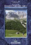
 Map showing area covered by the guide.
 Example of one of the trip maps from the guide.
 Index showing the route covered.
 Sample of a daily hiking map in the guide.