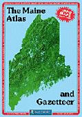
Maine Atlas and Gazetteer. 1:126,720. DeLorme.
Excellent road atlas with topographic maps and gazetteer.
Sample detail from the Maine atlas
$29.95
62-7148
Atlas
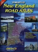
New England Road Atlas. Jimapco.
This spiral bound road atlas of New England covers Maine, New Hampshire, Vermont, Massachusetts, Connecticut, and Rhode Island. Includes major roads and highways, communities, lake & rivers, recreational features, and places of interest. 2011, second edition. Spiral-bound, ISBN 9781569146323.
$29.95
62-20959
Atlas.
Maine Travel and City Maps - Paper Maps.
Maine Road Maps - Paper Maps.
Maine Road Map. Rand McNally.
This is a detailed road map of Maine. The map includes inset maps of Acadia National Park, Augusta, Bangor, Brunswick/Bath, Kittery/Portsmouth, NH; Lewiston/Auburn, Portland, and Saco/Biddleford. Map size is 28 x 40 inches unfolded.
$7.99
62-7190
1 sheet, folded.
Maine City Maps - Paper Maps.
Maine City Maps - paper maps.
$5.95
62-7192BAN
Bangor, Bar Harbor, Acadia National Park street map. (GM Johnson).
$4.95
62-7192LE
Lewiston & Augusta street map. (GM Johnson).
$5.95
62-7192ME
Maine South Coast Beaches (Biddeford, Saco, Kennebunkport, Ogunquit, Old Orchard Beach) Map. (GM Johnson).
Maine Road & City Maps - Laminated Maps
Waterproof
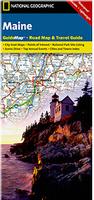
Maine Guidemap Laminated Road Map. National Geographic Maps. The front side is an easy-to-read road map with insets of: - Portland - Bangor - Lewiston / Auburn - Augusta The back includes: - Maps and information for Portland, Freeport/Yarmouth, and Bar Harbor - Information for Acadia National Park - Points of interest - Scenic drive - Park Service sites in Maine. Map size is 18 x 25 inches unfolded.
Sample detail from the Maine road map Front of the Maine road map
$7.95
62-71903
1 sheet, folded
Laminated Maine Easyfinder™ Laminated Road Map. Rand McNally. The durable and convenient Maine EasyToFold state map will take all the wear and tear your journey can dish out. The heavy-duty laminated design allows you to mark your route, make notes, then wipe the surface clean for further use. Map size is 17 x 18 inches unfolded, perfect for use in a car.
$9.99
62-71904
1 sheet, folded.
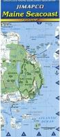
Laminated! Maine Seacoast Laminated Road Map. 1:270,000. Jimapco. A laminated map of the seacoast of Maine from New Hampshire to Canada. Inset expansions for New Castle to South Portland, Acadia National Park, Rockland, Portland, Booth Bay, Eastport and Calais. Size 19 x 25" unfolded.
$7.95
62-7173
1 sheet, folded.
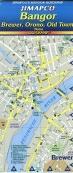
Laminated! Bangor City Street Map - Laminated Map. Jimapco. Folding, plastic coated map showing street level detail of Bangor, Brewer, Orono and Old Town in Maine. 25" x 19".
When it comes to general planning, defining delivery areas, planning direct marketing and delivering products, our city wall maps are perfect to get the detailed information you need.
These maps offer clear mapping by showing all major streets and roads and many of the smaller streets, but leaving out the smallest streets. If you want a clear map for easy planning, then these are the maps for you; if you want a map showing every little back alley, these are not for you.
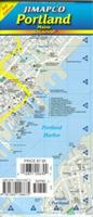
We offer wall maps for Portland.
Click here to order and to see sample images, prices, sizes, and mounting options.
Maine Bicycling Maps. Two popular long-distance trails traverse parts of Maine. These include the Northern Tier Transcontinental Trail that crosses Maine east-west and the Atlantic Coast Trail along Maine's beautiful coastline.
Shipwrecks of the Northeast USA Chart. 1:700.000. National Geographic Maps.
"Shipwrecks of the Northeast" is a stunning new map illustrating more than 5,400 known shipwrecks on the untamed Atlantic coast of New England (Maine, Massachusetts, New Hampshire and Rhode Island). From Rhode Islands' Narragansett Bay to Maine's St. Croix River, the shipwrecks are clearly marked atop beautiful bathymetric and coastal detail. Each wreck site is symbolized to define the class, type and name of vessel accompanied by the date of sinking. Icons also indicate whether a ship was lost due to conflict or natural causes. Size is 28 x 36 inches.
Image of the Shipwrecks of the Northeast USA map Sample of the Shipwrecks of the Northeast USA map
$19.99
62-1718
1 sheet flat
$29.99
62-1718L
Laminated.
Waterproof!
Acadia National Park Hiking Map. 1:35,000 & 1:100,000. Trails Illustrated/National Geographic Maps #212.
Detailed topographic hiking/canoe map showing trails, beaches, scenic view, campgrounds, and much more. Printed on waterproof, tear-resistant synthetic paper.
$14.95
63-2100-212
1 sheet, folded.
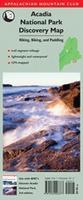
Waterproof! Acadia National Park Discovery Map. Appalachian Mountain Club.
Make the most of your trip to Acadia National Park with the waterproof Acadia National Park Discovery Map, 3rd Edition. This GPS-rendered topographic map is a compact yet comprehensive resource for exploring Maine's popular park on bike, water, or foot. Covering all hiking trails in the park, the map also includes bike routes on the Park's popular carriage roads, as well as shuttle and bus stops throughout the park. On one side you'll find a map of eastern Mount Desert Island in its entirety, including insets of Isle au Haut and Schoodic Peninsula. On the reverse is a close-up map of Eastern Mount Desert Island, detailing such popular treks as Jordon Pond, Bald Peak, Cadillac Mountain, and Cranberry Hill.
Samples of the Acadia National Park map
$9.95
62-7176
1 sheet, folded
Waterproof! Maine Trail Map - Baxter State Park/Katahdin, Rangeley/Stratton Region, Gulf Hagas. Appalachian Mountain Club.
This map is an essential addition to any hiker's pack. Full color and created using the latest GIS technology, this updated map includes 20 miles of new trail in Baxter State Park, with insets of trails in the Fowler Ponds and Trout Brook Mountain area, Kidney and Daicey Ponds area, and Katahdin. The reverse offers complete coverage of the hiking trails of the Rangeley-Stratton areas, including Bigelow Preserve. New to this map is coverage of the spectacular Gulf Hagas region.
Samples of the Maine trail map
$9.95
62-71765
1 sheet, folded
Maine Recreation Maps.
$7.95
62-7192BD
Baxter State Park. (DeLorme).
$5.95
62-7192ME
Maine South Coast Beaches map. (GM Johnson).
$9.95
62-7192SE
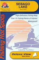
Sebago Lake map. (DeLorme).
$7.95
62-7192WH
White Mt. Trails. (DeLorme).
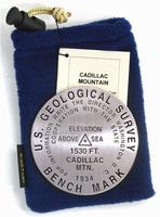
Cadillac Mountain benchmark paperweight, lapel pin, magnet, and zipper pull. Geo-Situ.
The highest point on the eastern coast of the United States, Cadillac Mountain rises high above the blue waters of Frenchman Bay. With its landscape of lichen-covered granite and stunted evergreen trees, the mountain's summit is extremely fragile. Faced with harsh weather and shallow soil, alpine plants cling precariously to life. Misplaced footsteps can destroy life that took years to develop. Whether you're a climber, hiker, geography buff, or armchair traveler, you'll love to collect or give these unique bench mark paperweights that celebrate the spirit of exploration, athletic challenge, and personal achievement. Cast in pewter these summit marker paperweights are exact replicas of official USGS benchmark markers. Please click the "sample" button below to see an enlargement of the paperweight. Each marker has a soft felt pad on the bottom so these can be used on glass, wood, or any surface. Supplied in a soft fleece drawstring pouch, 3¼" diameter.
The lapel pin and the zipper pull - pendant are a 1" replicas, all cast in pewter.
Larger image of the Cadillac Mountain paperweight.
Mt. Katahdin benchmark paperweight, lapel pin, magnet, and zipper pull. Geo-Situ. The northern terminus of the Appalachian Trail, Mt. Katahdin is one of the most popular mountains in the United States. Whether you're a climber, hiker, geography buff, or armchair traveler, you'll love to collect or give these unique bench mark paperweights that celebrate the spirit of exploration, athletic challenge, and personal achievement. Cast in pewter these summit marker paperweights are exact replicas of official USGS benchmark markers. Please click the "sample" button below to see an enlargement of the paperweight. Each marker has a soft felt pad on the bottom so these can be used on glass, wood, or any surface. Supplied in a soft fleece drawstring pouch, 3¼" diameter.
The keychain and magnet are 1-1/4" replicas while the lapel pin and the pendant are a 1" replica, all cast in pewter.
Larger image of the Mt. Katahdin paperweight.
$59.95
62-7197KA
Katahdin Benchmark Paperweight.
$9.95
62-7197KAP
Katahdin Benchmark Pendant.
$11.95
62-7197KAZ
Katahdin Benchmark Zipper pull.
$12.95
62-7197KAM
Katahdin Benchmark Magnet.
$12.95
62-7197KAK
Katahdin Benchmark Keychain.
Maine Wall Maps
Maine State and County Wall Maps. Intelligent Direct.
We offer state and county wall maps for all of the USA. The maps come in sizes from 24 x 36 to 108 x 144 inches. They are available in variety of mounting and framing options. The maps are ideal for business applications, sales territory, delivery planning, direct mail targeting and hundreds of other applications.
Click here to order county wall maps and to see sample images, descriptions, and prices.
Click here to order state wall maps and to see sample images, descriptions, and prices.
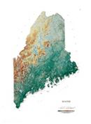
Maine Shaded Relief Wall Map. 1:500,000. Raven Maps. The Atlantic coast of Maine has over 400 islands which were created when a great ice sheet compacted hills, forcing them down into the water so that only the tops of the hills remain. West of the coastline is fertile farmland and beautiful pine forests. The Maine White Mountains contain spectacular Mount Katahdin. Elevations are represented by color, and this, in combination with our relief shading technique, gives the map a 3-dimensional look. Size is 91 x 122 cm (36 x 48").
Thumbnail of the map. Sample of the detail.
Maine Geologic Map. 1:500,000. 1985. Maine Geological Survey. The map includes numerous inset maps and a 248-reference bibliography. Map size is 144 x 105 cm.
$9.95
62-7100
1 sheet, folded.
Maine Surficial Geology Map. 1:500,000. 1985. Maine Geological Survey. A companion to map 62-7100 above, this new release shows glacial features and Quaternary geology. One sheet, 132 x 107 cm.
$9.95
62-7105
1 sheet, rolled.
Maine Bouguer Gravity Map. 1:500,000. 1966. USGS (GP-580). Map size is 74 x 112 cm.
$9.95
62-7112
1 sheet, folded
Maine Seismicity Map. 1:1,000. 1981. USGS (MF-1284). Map size is 76 x 102 cm.


 Sample detail from the Maine atlas

 Waterproof
 Sample detail from the Maine road map
 Front of the Maine road map
 Laminated
 Laminated!
 Laminated!
 Sample detail #1 of the Portland laminated map
 Sample detail #1 of the Portland laminated map
 Sample detail from the Portland wall map.
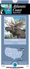

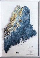

 Image of the entire Maine Lighthouses map.
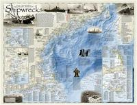
 Image of the Shipwrecks of the Northeast USA map
 Sample of the Shipwrecks of the Northeast USA map
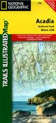 Waterproof!

 Waterproof!
 Samples of the Acadia National Park map
 Waterproof!
 Samples of the Maine trail map
 Larger image of the Cadillac Mountain paperweight.
 Larger image of the Mt. Katahdin paperweight.
 Maine State and County Wall Maps. Intelligent Direct.
 Thumbnail of the map.
 Sample of the detail.
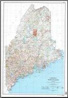
 Sample detail of the Maine topographic map.
 Image of the Maine topographic map.
 Maine Flags