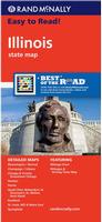
Illinois Atlas and Gazetteer. 1:150,000. DeLorme.
Excellent road atlas with topographic maps and gazetteer. Superb for backroads, forest service roads, etc.
Sample detail from the Illinois Atlas
$29.95
62-6548
Atlas
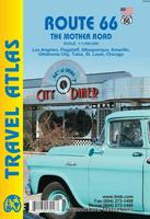
Route 66 Road Atlas. 1:1,000,000. ITMB.
The 'Mother Road' of the USA is one of the most famous highways of the world. When the highway was developed in the 1920s, America was just discovering the automobile and long-distance roads were visionary. Today, it has been replaced by the US Interstate system, but portions of the original highway remain, as well as many of its original buildings.
This atlas shows the route from its origins in Chicago, through Illinois and other states to California and its terminus in Santa Monica. The atlas shows the Route and has capsule comments about attractions; it includes parks, historic sites, and attractions within reasonable driving distances from Route 66. It covers the entire 2,400 miles of the Route and includes many detailed city plans of urban areas along the highway. 64 pages, printed on paper, saddle stitched. Center-stapled soft-cover atlas.
Sample detail of the Route 66 road atlas
$16.95
62-20973
Atlas.
Illinois Road Maps - Paper Maps
Illinois Road Map. Rand McNally.
Detailed road map of Illinois. The map includes inset maps of maps of: Bloomington/Normal, Champaign/Urbana, Chicago & Vicinity, Downtown Chicago, Decatur, Peoria, Quad Cities, Rockford, St. Louis & Metro East, and Springfield. Map size is 28 x 40 inches unfolded.
$9.99
62-6590
1 sheet, folded.
Great Lakes Travel Map. 1:1,000,000. ITMB.
Using this map, one can explore Lakes Ontario and Erie as circular routes; also Huron and Superior; visit Ottawa and Toronto, Chicago and Duluth, and find Fort WilliamWawa Goose. This is a double-sided map covering from Ottawa in the north to Pittsburgh and Columbus in the south and Duluth and Thunder Bay in the west. Both Canada and the USA portions of the Great Lakes Region are included.
Sample detail of the Great Lakes Travel Map
$9.95
62-20913-GL
1 sheet, folded.
$24.99
62-20913-GLW
1 sheet, flat.
$34.99
62-20913-GLL
1 sheet, laminated.
Southern Illinois Road Map. GM Johnson.
This detailed map features golf courses, campgrounds, airports, colleges and universities, historic sites, parks, recreation areas, points of interest, and much more. The map covers the southern quarter of Illinois, including Carbondale, Marion, etc.
$5.95
62-65904
1 sheet, folded.
Illinois Road Maps - Laminated Maps
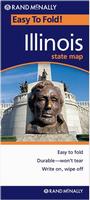
Illinois Easyfinder™ Road Map - Laminated. Rand McNally.
The durable and convenient Illinois EasyToFold state map will take all the wear and tear your journey can dish out. The heavy-duty laminated design allows you to mark your route, make notes, then wipe the surface clean for further use. Map size is 18 x 17 inches unfolded, perfect for use in a car.
$9.99
62-65901
1 sheet, folded.
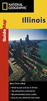
Laminated Illinois Guidemap - Laminated. National Geographic Maps.
The front side is an easy-to-read road map with insets of: - Rockford - Champaign / Urbana - Decatur - Peoria - Blommington / Normal - Quad Cities The back includes: - Map and information for Chicago - Points of interest - Map and information for Springfield - Scenic drive - Park Service sites in Illinois. Map size is 17 x 24 inches unfolded.
Sample detail of the Illinois road map. Image of the front of the Illinois road map.
$7.95
62-65902
1 sheet, folded.
Illinois City Maps - Paper Maps
Chicago City Maps - Paper Maps
Streets of Chicago Map. Rand McNally.
Detailed street map of Chicago. Includes coverage of Chicago, Berwyn, Bridgeview, Brookfield, Burbank, Cicero, Elmwood Park, Evergreen Park, Franklin Park, La Grange, Lyons, Oak Lawn, Oak Park, Riverside, and Willow Springs. Map size is 28 x 40 inches unfolded.
$6.99
62-6592CH
1 sheet, folded.
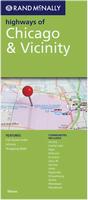
Highways of Chicago & Vicinity Map. Rand McNally.
This map covers the major roads of a wider area around Chicago. Includes coverage of Chicago, Aurora, Crystal Lake, Elgin, Elmhurst, Evanston, Gary, IN; Gurnee, Joliet, Naperville, Schaumburg, Skokie, Waukegan, and Woodstock. Map size is 28 x 40 inches unfolded.
$6.99
62-6592CR
1 sheet, folded.
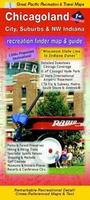
Chicagoland: City, Suburbs, & NW Indiana Street Map. Great Pacific Recreation Maps.
Comprehensive coverage from the Wisconsin State Line to Northwest Indiana.
Includes detailed inset maps of Downtown Chicago,Hyde Park and the U. of Chicago, O'Hare International Airport, Rosemont, and Chicago Transit Authority (CTA) Elevated & Subway Rapid Transit lines.
Also includes Metra, South Shore & Amtrak, Parks & Forest Preserves, Hiking & Biking Trails, Spectator Sports Venues, Shopping & Markets, Golf Courses, Museums & Historic Places, and Resorts & Conference Centers.
One of the inset maps on the Chicagoland street map
$5.95
62-6592CHK
1 sheet, folded.
Chicago & Lake Michigan Street Map. 1:12,000. ITMB.
Folded street map of Chicago. Legend shows places to stay and places of interest, train stations, Elevated transit lines, subways, parks, churches, museums, bicycle routes, department stores, Universities/colleges, buildings of architectural importance, and much more.
Sample detail from the Chicago street map Sample detail from the Lake Michigan side of the map
$8.95
62-65921IT
1 sheet, folded.
Chicago Metro 14-County Area Street Map. American Map.
The Chicago, IL Metro 14-Counties fold map is a full-color, regional map, including the counties of: Boone, Cook, DeKalb, DuPage, Grundy, Kane, Kendall, Lake, McHenry, and Will, in Illinois; and Kenosha, Milwaukee, Racine, and Waukesha, in Wisconsin; and features: detailed street insets of Downtown Chicago and Downtown Milwaukee, Golf Courses, Parks and Rec Areas, Places of Interest, and Universities.
$7.99
62-6592CM
1 sheet, folded.
Illinois City Maps. Various publishers.
$6.95
62-6592BL
Bloomington & Normal City Map. (GM Johnson). This covers Bloomington Illinois, not Bloomington, Indiana.
$5.99
62-6592CHAM
Champaign and Urbana Street Map. (Seeger).
$5.99
62-6592CG
Champaign/Urbana City Map. (Universal Map). Now out of print - limited stock left.
$5.95
62-6592NWC
Cook County Northwest street map. (GM Johnson).
$5.99
62-6592DE
DeKalb street map. (Seeger).
$5.95
62-6592ELG
Elgin and St. Charles city map. (GM Johnson).
$5.95
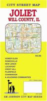
62-6592JOL
Joliet and Will County city map. (GM Johnson).
$5.95
62-6592LCN
Lake County North street map. Includes Antioch, Fox Lake, Grayslake, Gurnee and adjoining communities. (GM Johnson).
$5.95
62-6592LCS
Lake County South street map. Includes Highland Park, Lake Forest, Lake Zurich Libertyville and adjoining communities. (GM Johnson).
$5.95
62-6592MCHE
McHenry County street map. (GM Johnson).
$6.95
62-6592NAP
Naperville and Aurora city map. (GM Johnson).
$5.95
62-6592NOR
North Shore street map. (GM Johnson).
$5.99
62-6592NO
North Shore street map. (Universal). Now out of print - limited stock left.
$5.95
62-6592ORL
Orland Park City Map. (GM Johnson).
$5.99
62-6592PEO
Peoria Street Map. Includes surrounding towns. (Seeger).
$5.99
62-6592SPRI
(IL) Springfield & Decatur Street Map. (Seeger).
Illinois City Maps - Laminated Maps.
Laminated Chicago Bus Map. Streetwise.
Laminated Chicago Public Transportation Map - Bus, CTA - Folding pocket & wallet size mini metro map for travel around the city by public transport.
$1.95
62-65921CT
1 sheet, folded.
Laminated University of Chicago & Hyde Park Map - Laminated Map. Hedberg.
Amazing detail of UC and the surrounding neighborhoods. Every University and other institutional building and residence, along with shopping, dining and recreational detail. Includes a map connecting Hyde Park to the Loop, and a complete index.
Image of the back of the University of Chicago map
$6.95
63-1530
1 sheet, folded.
Waterproof Chicago Destination Map. 1:9,000. National Geographic Maps.
In addition to the easy-to-read map on the front, the back includes: - Regional map - Points of interest - Map and information for Lake Shore Drive & Lincoln Park - Chicago Transit Authority map - O'Hare International and Midway International airport diagrams. Map size is 17 x 24 inches unfolded.
Sample detail of the Chicago Destination map Front of the Chicago Destination map
$7.95
62-6592CN
1 sheet, folded.
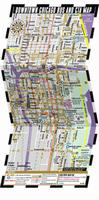
Laminated Downtown Chicago Plus Map. Great Pacific Recreation Maps.
Downtown & Edgewater to Hyde Park in exceptional detail. Large Scale, Color-Coded. Lakeside neighborhoods from Edgewater in the north through Downtown to Hyde Park on the south. Downtown Buildings. All Streets & Freeway Ramps. CTA Rail & Bus Lines. Metro area map with points of interest, freeways & METRA commuter rail.
$6.95
62-6592CHA
1 sheet, folded.
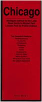
Waterproof Chicago Red Map. Red Map.
The essential guide to the best of Chicago. Highlighting Lincoln Park, Old town, the Gold Coast, the Loop, River North and Prairie Aveune Historic District. Serves as the ultimate guide to the cultural institutions, museums, architecture, parks and landmarks of Chicago, along with an easy to use metro 'L' map, and of course the best of shopping. Map size 24 x 9 inches unfolded.
Sample detail of the Chicago Red Map
$9.95
62-65921RC
1 sheet, folded.
Laminated Chicago Street Map. Borch.
Our soft-laminated folded map of Chicago shows Chicago Downtown 1:8,000, Lincoln Park 1:16,000, Hyde Park 1:20,000, Chicago & Region 1:250,000, O'Hare Airport 1: 22 500, Public Transportation CTA, Top 30 Sights and USA administrative & time zones. Borch Maps are easy to fold, durable and water-repellent with a wipeable surface. Borch Maps show hotels, museums, monuments, markets, public transport, top sights and points of interest, useful statistics, conversion charts for temperatures, weights and measurements, climate charts showing temperatures, sunshine hours, precipitation and humidity, overview maps, time zones, and much more.
Sample detail of the Chicago Street Map Front of the Chicago Street Map Reverse of the Chicago Street Map
$8.95
62-6592CJ
1 sheet, folded.
Waterproof Chicago MapEasy Map. MapEasy.
The Chicago Guidemap includes detailed sections for "The Magnificent Mile", the Shoreline of Chicago, Out-of-Town, and the transit system (CTA).
Sample detail of the Chicago MapEasy Map
$7.95
62-6592CE
1 sheet, folded.
Waterproof Chicago MapEasy Mini-Map. MapEasy.
This is a waterproof mini version of our MapEasy Chicago guidemap listed above.
$6.95
62-6592CHI
1 sheet, folded.
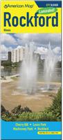
Laminated Rockford Laminated Street Map. American Map.
This all-in-one, laminated City Slicker Map of Rockford, Illinois includes Cherry Valley, Loves Park, Machesney Park and Rockford. This easy-to-read, four-color map also includes a convenient index that makes navigation quick and simple.
Now out of print - limited stock left.
$8.99
62-65921RO
1 sheet, folded.
Illinois City Wall Maps
Illinois City Wall Maps.
When it comes to general planning, defining delivery areas, planning direct marketing and delivering products, our city wall maps are perfect to get the detailed information you need.
These maps offer clear mapping by showing all major streets and roads and many of the smaller streets, but leaving out the smallest streets. If you want a clear map for easy planning, then these are the maps for you; if you want a map showing every little back alley, these are not for you.
We offer wall maps for Arlington Heights, Aurora, Berwyn, Bloomington, Bolingbrook, Champaign, Chicago, Cicero, Coles, Decatur, Des Plaines, Elgin, Evanston, Hoffman Estates, Joliet, Mount Prospect,
Naperville, Normal, Oak Lawn, Oak Park, Orland Park, Palatine, Peoria, Rockford, Schaumburg, Skokie, Springfield, Tinley Park, Waukegan, Wheaton.
Click here to see sample images, prices, sizes, and mounting options.
Illinois Recreation Maps
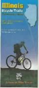
Illinois Bicycling Maps. Three popular long-distance trails traverse parts of Illinois. These include the Great Rivers South Trail, the Northern Tier Transcontinental Trail, and the TransAmerican Trail.
Click here for our complete US Forest Service maps list.
Illinois Wall Maps
Illinois State and County Wall Maps. Intelligent Direct.
We offer state and county wall maps for all of the USA. The maps come in sizes from 24 x 36 to 108 x 144 inches. They are available in variety of mounting and framing options. The maps are ideal for business applications, sales territory, delivery planning, direct mail targeting and hundreds of other applications.
Click here to order county wall maps and to see sample images, descriptions, and prices.
Click here to order state wall maps and to see sample images, descriptions, and prices.
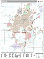
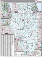
Illinois Wall Map. Kappa Map Group.
Data and details included are as follows: all state highways, all federal highways, cities and towns, major waterways, major airports, state parks, state universities, military installations, wildlife areas, a mileage chart, counties with populations, and points of interest.
The Kappa map has more detail than the Intelligent Direct maps above, but are more congested. Please see the example below.
Size is 50 x 67". Available laminated or laminated with plastic rails top and bottom.
Thumbnail of the map.
$209.99
62-65505
Laminated
$219.99
62-65505R
Laminated with rails
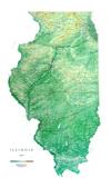
Illinois Shaded Relief Wall Map. 1:500,000. Raven Maps. Our Illinois map beautifully displays the delicate landscape. From Lake Michigan to the Ohio and Mississippi Rivers, the valleys, plains, rivers, and prairies are exquisitley mapped in shades of greens and light browns. Elevations are represented by color, and this, in combination with our relief shading technique, gives the map a 3-dimensional look. Size is 33 x 55".
Thumbnail of the map. Sample of the detail.
$40.00
62-6551
Each, rolled
$65.00
62-6551L
Laminated
Illinois Geology Maps
Illinois Quaternary Deposits Map. 1:500,000. 1979. Illinois State Geological Survey.


 Sample detail from the Illinois Atlas
 Sample detail of the Route 66 road atlas
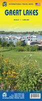
 Sample detail of the Great Lakes Travel Map
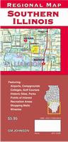
 Laminated
 Sample detail of the Illinois road map.
 Image of the front of the Illinois road map.
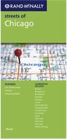
 One of the inset maps on the Chicagoland street map
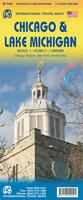
 Sample detail from the Chicago street map
 Sample detail from the Lake Michigan side of the map
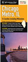

 Laminated
 Laminated
 Image of the back of the University of Chicago map
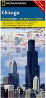 Waterproof
 Sample detail of the Chicago Destination map
 Front of the Chicago Destination map
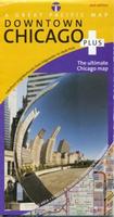 Laminated
 Waterproof
 Sample detail of the Chicago Red Map
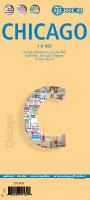 Laminated
 Sample detail of the Chicago Street Map
 Front of the Chicago Street Map
 Reverse of the Chicago Street Map
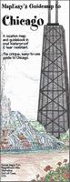 Waterproof
 Sample detail of the Chicago MapEasy Map
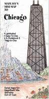 Waterproof
 Laminated

 Illinois State and County Wall Maps. Intelligent Direct.

 Thumbnail of the map.
 Thumbnail of the map.
 Sample of the detail.
 Illinois Flags