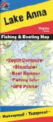
Virginia Fishing Maps by Fishing Hot Spots are superb maps showing the lake bottoms for hundreds of lakes and rivers across the USA. These maps are printed on either kimdura or Hop-syn (both tear-resistent waterproof synthetic materials), making them nearly indestructible. The maps show lake bottom contours, shoreline features, roads leading to the lakes, boating facilities along the lake shore, and much more.
Fishing Map sample Enlargement
$13.95
62-9893-A460
Lake Anna.
$13.95
62-9893-A461
Lake Chesdin.
$13.95
62-8593-A463
John H. Kerr Reservoir-East (Buggs Island East) (VA/NC).
$13.95
62-8593-A464
John H. Kerr Reservoir-West (Buggs Island West) (VA/NC).
$14.95
62-9893-L466
Smith Mountain Lake.
Kingfisher Fishing Maps
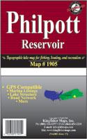
Waterproof! Philpott Reservoir Fishing Map. 1:24,000. One-Sided, 18"x24" full color aerial map of Philpott Lake, VA. Includes lake structure, river channel, creekbeds, submerged roads, railroads and buildings. Recreation Area locations and more!
Thumbnail view of the map
$8.99
62-9893-PH
1 sheet, folded.
Fishwater River Fishing Maps
Fishwater Fishing Maps for Virginia. C.S. Gibbs Design. These double-sided maps measure 11 x 17 inches and are printed on waterproof, tear resistant synthetic paper. They are finely crafted, highly graphic and completely functional. Each map features a hatch chart and recommended fly selection as well as other important information about the river and area. The maps also feature photographs of the river, and information to help you find local food and lodging.
$10.99
62-98933-NO
North River (Mossy Creek) Fishing Map. Harrisonburg, VA. Virginia's North River watershed is home to some of the states best trout fishing, providing ample opportunities to catch both stocked and wild fish. This map covers The North River, Mossy Creek, Beaver Creek, Skidmore Fork and The Dry River.
$10.99
62-98933-WH
Whitetop Laurel Creek Fishing Map. Damascus, VA. Whitetop Laurel Creek is a small to medium sized freestone Stream in the far southwestern tip of Virginia which flows through the outdoorsy town of Damascus. Many consider it to be the best trout stream in the Old Dominion. Our full color waterproof map includes the entire Whitetop Laurel, as well as the TN Laurel, Beaverdam Creek and a large section of the Virginia Creeper Trail.
Sealake Coastal Fishing Maps
Mid-Atlantic Coastal Fishing Maps. Sealake Products. Sealake, best known for its shipwreck charts (see Mid-Atlantic Shipwreck Charts), is producing a series of laminated coastal fishing charts with data overlain on nautical chart base maps.
These fishing charts are reproductions of NOAA charts or aerial photographs (Murrells Inlet and White Oak River) and are frequently updated with the latest buoy and channel information.
Many show "BiteZones" for trout, flounder, redfish, spots, bluefish, and others. The charts are magnified and show insets for better readability.
They are also a handy size, perfect for day to day use on all boats. Many charts show the GPS numbers of points, "BiteZones," creek entrances and creek junctions.
Valuable fishing and area information is compiled with the help of local fishermen and guides. Many chart borders also have a latitude and longitude scale.
$16.99
62-98932-LY
Lynnhaven Bay & Currituck Sound. Virginia Beach, Corolla. ;
GMCO Fishing Maps
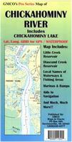
Waterproof! Chickahominy River & Chickahominy Lake Chart & Fishing Map. 1:24,000. GMCO Maps, 2000. The map covers from Chickahominy Lake to the James River and a lot of detail in between!! Includes a 30 second grid for GPS, ramps, marinas, aid to navigation, local names of waterways and much more!
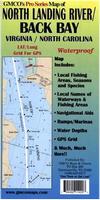
Waterproof! North Landing River & Back Bay Chart & Fishing Map. 1:30,000. GMCO Maps, 2008. The map covers from Sandbridge to Coinjock, VA/NC. The map includes lat/long grid for GPS, Local Names of waterways and fishing grounds, shows ramps, marinas, and much more!!
$9.95
62-9893BB
1 sheet, folded.
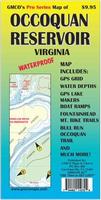
Waterproof! Occoquan Reservoir Chart & Fishing Map. 1:9,600. GMCO Maps, 2009. Map includes GPS Grid, Marina Facilities, GPS Lake Markers, Bull Run Occoquan Trail from Bull Run Marina to Fountainhead Park, Water depths, Local Names And Much MORE!!
$9.95
62-9891O
1 sheet, folded.
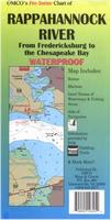
Waterproof! Rappahannock River Chart & Fishing Map. 1:80,000. GMCO Maps, 2006. Enlarged scale from Fredericksburg to Tappahannock. Includes Local names, navigational aids, ramps, GPS Grid and More!!
$9.95
62-9893RAP
1 sheet, folded.
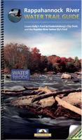
Rappahannock River Water Trail Guide. 1:80,000. Friends of the Rappahannock River/GMCO Maps, 2006.
Covers Kellys Ford to Fredericksburgs City Dock, and the Rapidan River below Elys Ford
$19.99
62-9893RAG
Atlas.
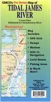
Waterproof! Tidal James River Chart & Fishing Map. 1:30,000. GMCO Maps, 2001. Covers from Richmond to the Chickahominy River Enlarged scale 1:30,000 from Richmond to Jordan Point, 1:40,000 scale from Jordan Point to the Chickahominy River also includes the Appomattox River up to Petersburg. Grid for GPS, ramps, marinas, navigational aids, local area names, and more!
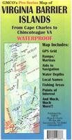
Waterproof! Virginia Barrier Islands Chart & Fishing Map. GMCO Maps, 2002. Covers from Chincoteague to Cape Charles. Includes: Local names of waterways and landmarks, LAT/LONG Grid for GPS aids to navigation, ramps, marinas and more!
$9.95
62-9891VB
1 sheet, folded.
Waterproof! York River Chart & Fishing Map. 1:80,000 & 1:40,000. GMCO Maps, 2010. Includes the Mattaponi River and Pamunkey River at 1:40,000. With launching sites. Lat./Long. Grid for GPS, Navigational Aids, Local Names of waterways and fishing areas.
 Fishing Map sample
 Enlargement
 Waterproof!
 Thumbnail view of the map
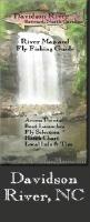


 Waterproof!
 Waterproof!
 Waterproof!
 Waterproof!
 Waterproof!
 Waterproof!
 Waterproof!