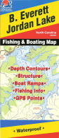
Fishing Maps by Fishing Hot Spots are superb maps showing the lake bottoms for hundreds of lakes and rivers across the USA. These maps are printed on either kimdura or Hop-syn (both tear-resistent waterproof synthetic materials), making them nearly indestructible. The maps show lake bottom contours, shoreline features, roads leading to the lakes, boating facilities along the lake shore, and much more.
Fishing Map sample Enlargement
$13.95
62-8593-A312
B. Everett Jordan Lake fishing map.
$13.95
62-8593-A313
Falls Lake fishing map.
$13.95
62-8593-A314
Lake Gaston fishing map.
$13.95
62-8593-A315
High Rock Lake fishing map.
$13.95
62-8593-A316
Lake Norman fishing map.
$13.95
62-8593-A463
John H. Kerr Reservoir-East (Buggs Island) (NC/VA) fishing map.
$13.95
62-8593-A464
John H. Kerr Reservoir-West (Buggs Island) (NC/VA) fishing map.
$14.95
62-8593-AL850
Lake Wylie (NC/SC) fishing map.
Saltwater fishing maps
$19.95
62-8593-NC0104
Cape Lookout - Bogue Sound to Drum Inlet. NC0104.
$19.95
62-8593-NC0101
Long Bay - Sunset Beach. NC0101.
$19.95
62-8593-NC0105
Raleigh Bay - Sealevel to Hatteras. NC0105. Out of print and available while supplies last.
Fishwater Fishing Maps for NC and TN. C.S. Gibbs Design. The maps measure 11 x 17 inches and are printed on waterproof, tear resistant synthetic paper. They are finely crafted, highly graphic and completely functional. Each map features a hatch chart and recommended fly selection as well as other important information about the river and area. The maps also feature photographs of the river, and information to help you find local food and lodging.
Index map showing locations of the fishing maps.
$12.99
62-62933-CHA
Chattooga River Fishing Map. North Carolina-Georgia-South Carolina.
$10.99
62-94933-HI
Hiwassee River, TN fishing map. The Hiwassee is a big tailwater close to the NC/TN/GA border. The mix of cold water and mild climate make it a wonderful year round fishery and its wide open character make it a perfect river to float.
$10.99
62-85933-NTL
North Toe River - Lower section, NC fishing map. The Lower North Toe River is a top shelf smallmouth bass fishery and a fantastic river to float in either a canoe, drift boat, or personal watercraft. The map shows the river from Spruce Pine to the confluence with the South Toe where the river becomes the Nolichucky.
$10.99
62-85933-NTU
North Toe River - Upper section, NC fishing map. The Upper North Toe River is a medium sized, freestone river providing many trout fishing opportunities in its watershed. The map shows the river from its headwaters to the town of Spruce Pine and includes the Delayed Harvest Section. It has all the info you need to get on the water, including hatch charts, recommended flies, access points and local info.
$10.99
62-85933-OCO
Oconaluftee River Fishing Map. Cherokee, North Carolina.
$10.99
62-94933-SH
South Holston River, TN fishing map. The South Holston Tailwater is arguably the finest cold water fishery in the south. Wild brown trout are the predominate species and 20 plus inch fish are common, with behemoths up to 10 plus pounds caught every season.
$10.99
62-85933-STO
South Toe River Fishing Map. Burnsville, North Carolina.
$10.99
62-85933-TU
Tuckasegee River, NC fishing map. The Tuckasegee Tailwater is a wide open river with quality trout habitat and includes a popular Delayed Harvest Section. The lower portion of the river, from Dillsboro to Bryson City provides great smallmouth bass fishing. The map shows the river from the dam to Bryson City, NC.
$10.99
62-85933-TUL
Tuckasegee River - Lower section, NC fishing map. The Lower Tuckasegee River, from Dillsboro to Bryson City provides great smallmouth bass fishing. It is a wide open river great for wet wading on a hot summer day. The map shows the river from the Dillsboro to Bryson City, NC.
$10.99
62-85933-TUU
Tuckasegee River - Upper section, NC fishing map. The Upper Tuckasegee Tailwater is the most heavily stocked stretch of river in North Carolina. It is a wide open river with quality trout habitat and includes a popular Delayed Harvest Section.
$10.99
62-94933-WA
Watauga River, TN fishing map. The Watauga River, or Wilbur Tailwater, is a premier cold water fishery in Eastern Tennessee. The river is renowned for it's heavy caddis hatches in the spring and provides quality fishing year round. The map shows the river from above Wilbur Dam to Boone Lake.
$10.99
62-85933-WR
Wrightsville Beach, NC fishing map. Wrightsville Beach is a popular destination for summer beach goers and provides some great opportunities for fly casters.
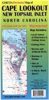
Waterproof! Cape Lookout & New Topsail Inlet Chart & Fishing Map. 1:80,000. GMCO Maps, 2009. Covers from Core Banks to New Topsail Inlet. Includes an enlargement of Morehead. Includes; Navigational Aids, water depths wrecks, marina, Lat./Long. Grid for GPS, local names, artificial reefs, fishing areas with species and seasons and much more!
$9.95
62-8593CL
1 sheet, folded.
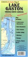
Waterproof! Lake Gaston Chart & Fishing Map. 1:24,000. GMCO Maps, 2003. Lake Gaston is a 20,0000 acre reservoir located on the NC/VA border. The lake has 350 miles of shoreline and is well-known for producing excellent largemouth bass, stiped bass, and some walleye, crappie, and white perch. Waterproof, Special GPS Grid, Includes; Marinas, underwater structure, area names, street names and MORE!
$9.95
62-8593GA
1 sheet, folded.
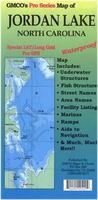
Waterproof! Jordan Lake Chart & Fishing Map. 1:24,000. GMCO Maps, 2006. Waterproof With Lat/Long Grid for GPS, Underwater structure, Water depth contours, Facilities Listing and more!
$9.95
62-8593JL
1 sheet, folded.
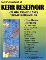
Kerr Reservoir (Buggs Island Lake) Chartbook. 1:24,000. GMCO Maps, 2007. Complete Fishing and Recreational guide to Kerr Reservoir 26 pages of easy-to-use charts, facilities listing, local names, LAT/LONG Grid for GPS and more!!
$12.95
62-8593KE
1 sheet, folded.
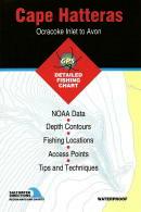
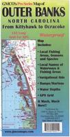
Waterproof! Outer Banks Chart & Fishing Map. 1:80,000. GMCO Maps, 2009. The map covers from Kitty Hawk to Ocracoke. It features 1' longitude/latitude grid, local fishing areas, seasons and species notations, fishing area wrecks, artificial reefs, water depths, aids to navigation, and much more.
$9.95
62-8593OUT
1 sheet, folded.
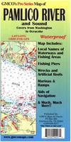
Waterproof! Pamlico River Chart & Fishing Map. 1:80,000. GMCO Maps, 2009. The map covers from Washington to Ocracoke. It includes a 1-minute lat-long grid, local fishing areas, notes on fish species and seasons, local names of waterways, artificial reefs, aids to navigation, and more.
$9.95
62-8593PAM
1 sheet, folded.
Waterproof! Wrightsville, NC to Little River, SC Chart & Fishing Map. 1:80,000. GMCO Maps, 2009. Includes marinas, underwater structures, street names, area names and much more!
$9.95
62-8593WR
1 sheet, folded.
Fishing Maps by Kingfisher Maps. These maps show the topography of the lakebottoms and locations of shore facilities and lake buoys. Folded maps printed on Polyart synthetic "paper," making them nearly indestructible. With GPS coordinate information unless noted otherwise. The maps have GPS coordinate information unless noted otherwise.
$11.99
62-8594-FO
(NC) Fontana fishing map. 1:31,000. Single-sided, 23" x 35". Fontana Lake could be called the best-kept secret in the Smoky Mountains. Just consider a 29-mile long lake, with more than 240 miles of shoreline and 11,685 acres of water surface. Its deep, cold waters provide ideal habitat for a variety of fish. In fact, record size musky and walleye have been pulled from its depths.
(NC) High Rock, Tuckertown, Badin, & Tillery Lakes fishing map. 1:40,000 and 1:36,000. Double-sided, 25" x 38". GPS compatible, marina listings, lake structure, road network and more.
$11.99
62-8594-JB
James - Rhodiss fishing map.
$11.99
62-8594-SH
(NC) Shearon Harris fishing map. Shearon Harris is a large lake bisected by the Wake County and Chatham County line. The 13,377-acre lake was constructed to supply cooling water for the Shearon Harris Nuclear Power Plant.
Mid-Atlantic Coastal Fishing Maps. Sealake Products. Sealake, best known for its shipwreck charts (see Mid-Atlantic Shipwreck Charts), is producing a series of laminated coastal fishing charts with data overlain on nautical chart base maps.
These fishing charts are reproductions of NOAA charts or aerial photographs (Murrells Inlet and White Oak River) and are frequently updated with the latest buoy and channel information.
Many show "BiteZones" for trout, flounder, redfish, spots, bluefish, and others.
The charts are magnified and show insets for better readability.
They are also a handy size, perfect for day to day use on all boats.
Many charts show the GPS numbers of points, "BiteZones," creek entrances and creek junctions.
Valuable fishing and area information is compiled with the help of local fishermen and guides.
Many chart borders also have a latitude and longitude scale.
$17.99
62-85932-BE
Beaufort Inlet. Morehead City, Atlantic Beach.
$17.99
$15.99
62-85932-BI
Bogue Inlet to New River Inlet. Swansboro, Sneads Ferry.
$15.99
62-85932-BO
Bogue Sound.
$15.99
62-85932-CF
Cape Fear River.
$15.99
62-85932-CG
Cape Fear River to Hog Inlet. Southport, Little River, Calabash.
$15.99
62-85932-CH
Cape Fear to Little River.
$15.99
62-85932-CM
(SC) Cape Fear to Murrell's Inlet.
$15.99
62-85932-CL
Cape Lookout to New River.
$17.99
62-85932-NE
Neuse River. Oriental, New Bern.
$15.99
62-85932-NR
New River. Jacksonville & Sneads Ferry.
$15.99
62-85932-NS
New River to Cape Fear.
$15.99
62-85932-SU
Surf City to Carolina Beach. Carolina Beach, Topsail, Wrightsville Beach.
 Fishing Map sample
 Enlargement
 Index map showing locations of the fishing maps.


 Waterproof!
 Waterproof!
 Waterproof!
 Waterproof!
 Waterproof!
 Waterproof!
 Fishing Maps by Kingfisher Maps. These maps show the topography of the lakebottoms and locations of shore facilities and lake buoys. Folded maps printed on Polyart synthetic "paper," making them nearly indestructible. With GPS coordinate information unless noted otherwise. The maps have GPS coordinate information unless noted otherwise.


