Colorado's Best Fishing Waters guidebook. Wilderness Adventures Press.
Maps, maps, and more maps! Colorado's Best Fishing Waters has 213 detailed full-color 8-1/2 x 11 maps of 73 of the best rivers, lakes, and streams in Colorado. Each water has a large overview map of the entire water. Then there are a number of maps for each section of that water showing river miles, access points with GPS coordinates, boat launches, rapids, dams, public and private roads, campgrounds, and fishing notes. Here are just some of the waters covered: the Animas River, Arkansas, Big Thompson, Blue, Colorado, Dolores, Eagle, Elk, Frying Pan, Gunnison, Laramie, North Platte, Rio Grande, Roaring Fork, San Juan, St. Vrain, Yampa, and more along with the lakes: Aurora Reservoir, Grand Mesa Lakes, Jackson Reservoir, Lake Granby, Pearl Lake, Red Feather Lakes, Steamboat Lake and many more. This is the most comprehensive book of angling maps ever created for Colorado's rivers and lakes.
Sample detail #1 from the Colorado fishing atlas. Sample detail #2 from the Colorado fishing atlas.
$29.95
62-5793A
Atlas
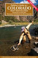
Flyfishers Guide to Colorado. Wilderness Adventures Press.
Breaking the state into six sections, the author, a Colorado native and guide, blends his personal knowledge with the experience of state biologists and regional shop owners to offer the most complete flyfishing guide ever offered on Colorado. Also includes a warm-water section.
$28.95
62-5795FGC
Guide.
Colorado River Fishing Maps by Wilderness Adventures Press. An essential tool for a successful fly-fishing trip is a detailed map of the water. One that will give you the access points, boat launches, campgrounds, public areas, roads, and GPS coordinates to pinpoint your location.
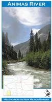
Animas River fishing map. Animas River from headwaters to New Mexico border.
$9.95
62-57933-BIG
Big Thompson River fishing map. Big Thompson River from Lake Estes to Drake.
$9.95
62-57933-CAC
Cache la Poudre River fishing map. Cache la Poudre River, from headwaters to Fort Collins.
$9.95
62-57933-CON
Conejos River fishing map. From headwaters to Rio Grande.
$9.95
62-57933-FRY
Fryingpan River fishing map. Headwaters to Roaring Fork..
$9.95
62-57933-GMN
Grand Mesa North River fishing map. Northern half of the Grand Mesa.
$9.95
62-57933-GMS
Grand Mesa South River fishing map. Southern half of the Grand Mesa.
$9.95
62-57933-GUN
Gunnison River fishing map. The Gunnison River from Blue Mesa Reservoir to the Colorado River.
$9.95
62-57933-PIE
Piedra River fishing map. Piedra River, from headwaters to Navajo Reservoir.
$9.95
62-57933-RIG1
Rio Grande River #1 fishing map. From Creede to South Fork.
$9.95
62-57933-RIG2
Rio Grande River #2 fishing map. From South Fork to Del Norte.
$9.95
62-57933-ROA
Roaring Fork River fishing map. From headwaters to Colorado River.
$9.95
62-57933-SPI
South Platte River #1 fishing map. "Dream Stream" section of the South Platte River from Spinney Mountain Reservoir to Elevenmile Canyon Reservoir.
$9.95
62-57933-SPL
South Platte River #2 fishing map. South Platte River from Spinney Mountain Reservoir to Chester Lake.
$9.95
62-57933-TAY
Taylor River fishing map. Headwaters to Gunnison River.
$9.95
62-57933-YAM
Yampa River fishing map. Yampa River from Stillwater Reservoir (Bear River) to west of Milner.
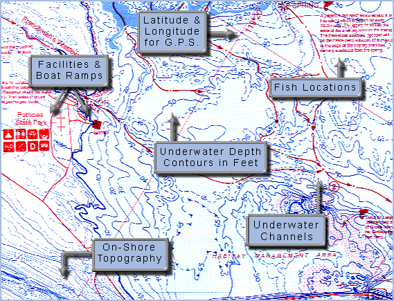
Fish-N-Map Company underwater topography maps are printed on a waterproof, tear-resistant material and are folded to 9" x 4". When opened, each map is approximately 3' x 2' in size and is printed on both sides. These maps feature waterproof plastic "paper"; underwater
depth contours; fish locations; latitude and longitude for GPS; often multiple lakes on one map; boat ramps; recreational facilities; and much more.
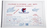
Colorado and Wyoming Lake Fishing Atlas. Includes maps of 44 Colorado lakes, 3 Wyoming lakes, and 1 Nebraska lake. All maps are blue/white maps with bottom contour lines. The atlas is 19 x 12 inches, spiral-bound, paper (not waterproof).
The lakes included in the atlas are: Adobe Creek Reservoir (Blue Lake), Antero Reservoir, Aurora Reservoir, Barr Lake, Blue Lake (Adobe Ck), Blue Mesa Reservoir, Bonny Reservoir, Boulder Reservoir, Boyd Lake, Carter Reservoir, Chatfield Reservoir,
Cherry Creek Reservoir, Delaney Butte Reservoir, Dillon Reservoir, Elevenmile Reservoir, Glendo Reservoir, Granby, Lake, Grand Lake, Grayrocks Reservoir, Green Mountain Reservoir, Gross Reservoir, Horsetooth Reservoir,
Jefferson Lake, Lake John, John Martin Reservoir. Lake McConaughy, McPhee Reservoir, Neegronda Reservoir, Neenoshe Reservoir, North Sterling Reservoir, Pearl Lake, Pueblo Reservoir, Queens Reservoir, Quincy Reservoir, Rampart Reservoir,
Sanchez Reservoir, Seminoe Reservoir, Shadow Mountain Reservoir, Spinney Mountian Reservoir, Stagecoach Reservoir, Standley Lake, Steamboat Lake, Tarryall Reservoir, Taylor Park Reservoir, Turquoise Lake, Twin Lakes,
Vallecito Reservoir, Williams Fork Reservoir, Wolford Mountain Reservoir. The atlas also includes information on structure fishing and information on analyzing a Lake.
$39.95
62-5793-CO
Atlas
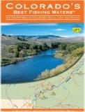
Colorado Fishing Maps.
$16.95
62-5793-BL
Blue Mesa fishing map. 10' contours.
$16.95
62-5793-BO
Bonny, Boyd, Barr fishing map. 2' contours.
$16.95
62-5793-CB
Chatfield, Carter Reservoir, Jefferson, South Platte River fishing map. 5' contours.
$16.95
62-5793-CJ
Cherry Creek, Aurora, Quincy fishing map. 4' contours.
$16.95
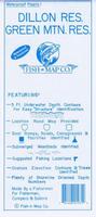
62-5793-DI
Dillon Reservoir, Green Mountain fishing map. 5' contours.
$18.95
62-5793-EL
Elevenmile, Adobe Creek, Sanchez fishing map. 5' contours.
$16.95
62-5793-GR
Granby, Grand Lake, Shadow Mountain fishing map. 5' contours.
 Sample detail #1 from the Colorado fishing atlas.
 Sample detail #2 from the Colorado fishing atlas.
 Flyfishers Guide to Colorado. Wilderness Adventures Press.
 Front of the Gunnison River fishing map
 Sample detail from the front of a river map from this series (Deschutes River)
 Sample detail from the back of a river map from this series (Truckee River)
 A sample of a map legend.