Fish-N-Map Company underwater topography maps are printed on a waterproof, tear-resistant material and are folded to 9" x 4". When opened, each map is approximately
3' x 2' in size and is printed on both sides. These maps feature waterproof plastic "paper"; underwater depth contours; fish locations; latitude and longitude for GPS; often multiple lakes on one map; boat ramps; recreational facilities; and much more.
Navajo fishing map (CO/NM). 20' contours. This same map is also listed in our Colorado Fishing Maps section.
$16.95
New Mexico River Fishing Maps by Wilderness Adventures Press. An essential tool for a successful fly-fishing trip is a detailed map of the water. One that will give you the access points, boat launches, campgrounds, public areas, roads, and GPS coordinates to pinpoint your location.

 A sample of a map legend.
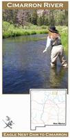
 Front of the Cimarron River fishing map
 Sample detail from the front of a river map from this series (Deschutes River)
 Sample detail from the back of a river map from this series (Truckee River)