(SD) Black Hills National Forest Map. 1:90,000. 2017. With shaded relief but no contours; waterproof.
$19.99
62-99774
(WA) San Juan Islands Map. 1:63,360. 2015. Waterproof, with shaded relief.
$19.99
62-99773
(WA) Tonasket Ranger District Map - Okanogan-Wenatchee National Forest. 1:63,360. 2017. Grass and shrubs dot the lower elevations, climbing to beautiful ponderosa pine forests at mid-elevations, then Douglas fir/western larch, and the subalpine and alpine forest at elevations above 6,000 feet.
More than 180 miles of trail are maintained for hikers, horseback riders, and motorized recreationists. There are several developed campgrounds as well as many opportunities for dispersed recreation. Waterproof, with contour lines.
$19.99
63-00780
(WV) Monongahela National Forest Map. 1:126,720. 2017. Without contours lines; waterproof.
U.S. College & University Map.
Colleges & Universities of the United States. Hedberg Maps, 2017.
A great tool for prospective students, counselors, and educational planners! 1400+ top colleges in the US and Canada, identified as public or private, single-sex, and religiously affiliated, with a handy index by name along the bottom.
Available folded or flat/laminated. Size is 39 x 27 inches flat/unfolded.
Sample of the map detail Thumbnail image of the map
$14.99
62-20773
1 sheet, folded.
$39.99
62-20773L
Laminated.
Appalachian Trail Topographic Map Guides
Appalachian Trail Topographic Map Guides. 1:63,360. National Geographic Maps, 2016.
Each Appalachian Trail (A.T.) Topographic Map Guide includes detailed topographic maps at 1:63,360 scale. Each page is centered on the A.T. and overlaps with the adjacent pages so there is little chance of getting lost. Each page has an elevation profile that shows the distance between shelters, camping areas, and trail access points.
The map and trail profile provide a step by step visual guide to hiking the trail, mile by rugged mile. The Topographic Map Guide is built for all levels of hiking enthusiasts, from the day tripper to the multi-month 'thru-hiker'. The front pages of the printed Topographic Map Guide include resupply information, town inset maps, camping options, and much more.
Sample details from the Appalachian Trail Hiking Map.
$14.95
63-5190-1501
Springer Mountain, GA to Davenport Gap, TN/NC hiking map.
$14.95
63-5190-1502
Davenport Gap, TN/NC to Damascus, VA hiking map.
$14.95
63-5190-1503
Damascus, VA to Bailey Gap, VA hiking map.
$14.95
63-5190-1504
Bailey Gap, VA to Calf Mountain, VA hiking map.
$14.95
63-5190-1505
Calf Mountain, VA to Raven Rock, MD/PA hiking map.
$14.95
63-5190-1506
Raven Rock, MD/PA to Swatara Gap, PA hiking map.
$14.95
63-5190-1507
Swatara Gap, PA to Delaware Water Gap. PA hiking map.
$14.95
63-5190-1508
Delaware Water Gap. PA to Schaghticoke Mountain, NY hiking map.
$14.95
63-5190-1509
Schaghticoke Mountain, NY to East Mountain MA/VT hiking map.
$14.95
63-5190-1510
East Mountain MA/VT to Hanover, VT/NH hiking map.
$14.95
63-5190-1511
Hanover, VT/NH to Mount Carlo, NH/ME hiking map.
$14.95
63-5190-1512
Mount Carlo, NH/ME to Pleasant Pond, ME hiking map.
$14.95
63-5190-1513
Pleasant Pond, ME to Katahdin, ME hiking map.
Pacific Northwest Wine Map
Pacific Northwest Wine Map. DeLong.
The unique climate of the Pacific Northwest is particularly conducive to high quality wines.
The map shows all of the official wine regions of Oregon, Washington and British Columbia as well as detail maps of Walla Walla Valley and the Northern Willamette Valley. It also includes statistics regarding acreage and major grape varieties of each state. Map size is 24 x 36"
New edition Rock Hill Street Map. Apple Valley Maps (formerly Map Supply). 2017.
$6.95
62-9292R
1 sheet, folded
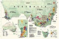
Australia Wine Map
New map! Australia Wine Map. DeLong. December, 2015.
The map shows all of Australia's official wine zones and regions as well as a detail map of Adelaide and the wine growing areas of Tasmania. It also includes statistics regarding acreage and major grape varieties of each state. Size is 24 x 36".
Outback New South Wales map. 1:1,100,000. Hema, 2013.
A regional map of outback NSW (1:1,100,000) that ranges from Tamworth in the east to Broken Hill in the west, as well as from Wagga Wagga in the south to past the Queensland border in the north. On the opposite side is extensive information on numerous regions, including visitor, historical and background information. Covered regions include the Broken Hill region, Corner Country, east of Tibooburra, the White Cliffs region, Cobar and surrounds, around Back o'Bourke, Lightning ridge and surrounds, Wentworth region, Balranald, Griffith region, Dubbo and surrounds, Kinchega National Park, Mungo National Park, Sturt National Park and Mutawintji National Park.
$7.95
64-1388-90
1 sheet, folded.
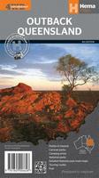
Outback Queensland map. 1:1,500,000. Hema, 2013.
This map ontains mapping and visitor information for one of the most iconic regions in Australia. The 1:1,500,000 map covers from the inland borders to Toowoomba in the east and Charters Towers in the north, with hill shading and elevation tinting creating a more realistic interpretation of the landscape within the region. Marked on the map are points of interest, camping areas and caravan parks as well as fuel and touring routes. Accompanying the mapping is extensive visitor information for the Channel Country, Matilda Country and the Overlanders Way, with a town and locality index.
$5.95
64-1388-80
1 sheet, folded.
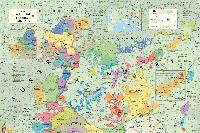
Austria & Hungary Wine Map
New map! Austria and Hungary Wine Map. DeLong. December, 2017.
Once an empire, Austria and Hungary both have long traditions of wine making.
The map shows all of Austria and Hungary's official wine regions as well as adjacent regions in Czech Republic, Slovakia, Romania, Serbia, Croatia and Slovenia. Detailed maps of Wachau, Kremsal and Kamptal and Tokaj are included. Size is 24 x 36".
New editions of topographic road atlases for Canada! Canadian Backroads Atlases. Backroad Map Books.
These atlases offer coverage of Canada similar to the well-known DeLorme state atlases for the USA. These detailed atlases show all of the backroads, including logging roads, contour lines on the maps, extensive tourist information, and much more.
Recreational Features: Trail systems, symbols, management units and more
Road Features: Complete classified road systems, road names and more
UTM Grid & Longitude and Latitude: both grids are included for GPS users
Reference Section: Comprehensive write up on Fishing, Paddling, Parks, Trails, Winter Recreation and more
Click here for a complete list of the Canada Backroads Mapbooks.
Southern Alberta Backroads Atlas. 2017, 4th edition.
$32.99
64-26940-22
Vancouver Coast and Mountains Backroads Atlas. 2017, 4th edition.
$32.99
64-26940-02
Vancouver Island Backroads Atlas. 2017, 8th edition.
France Wine Region Map Postcards
Wine Region Postcards! Editions Benoit.
Attractive postcards of the famous wine regions of France. Printed on coated postcard stock, these make great little add-ons to go with a gift bottle of wine, or as a memento of a favorite locale. These cards measure approximately 4.1 x 5.8 inches. In French.
Click here for the complete list of France wine maps and postcards.
$3.99
64-5680-ANJ
Anjou wine region postcard.
$3.99
64-5680-BER
Bergerac wine region postcard.
$3.99
64-5680-CAH
Cahors wine region postcard.
$3.99
64-5680-CEN
Centre-Loire wine region postcard.
$3.99
64-5680-COR
Corse wine region postcard.
$3.99
64-5680-GRA
Graves wine region postcard.
$3.99
64-5680-JUR
Jura wine region postcard.
$3.99
64-5680-SAN
Sancerre wine region postcard.
$3.99
64-5680-SAU
Sauternes wine region postcard.
$3.99
64-5680-STE
Ste Emilion wine region postcard.
$3.99
64-5680-SUD
Sud Ouest wine region postcard.
$3.99
64-5680-TOU
Touraine wine region postcard.
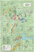
Germany Wine Map
New map! Germany Wine Map. DeLong. December, 2014.
This highly detailed map shows all of the main regions including the top vineyard areas, top wine villages and grape varieties. It also includes vineyard maps of the Mosel and Rheingau regions.
It's a great way to come to terms with the complexities of German wine.
New title Mount Mulanje Hiking Map. 1:50,000. EWP, 2017.
Detailed, full-colour topographical map of Mount Mulanje, Malawi. The reverse side has useful information on walking routes, accommodation, history, flora and fauna, weather, geology, and photos of area. The map has 25m contours.
$19.99
64-9975
1 sheet, folded.
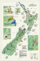
New Zealand Wine Map
New title New Zealand Wine Map. DeLong. December, 2016.
It shows all wine regions and subregions as well as a detailed maps of Central Otago, Marlborough, Wairarapa, Hawke's Bay and Gisborne. It also includes statistics regarding acreage and major grape varieties of each region. Map size is 24 x 36 inches.
New guide! Lofoten Islands Hiking Guide. Souyris & Brede, 2017.
Hiking the Lofoten Islands is both an invitation to discover this bit of Arctic paradise and a practical guidebook that answers two questions, essential for any hiker:
Where should I hike on each of the islands, given the time I have, the weather, and my physical condition?
What itineraries should I follow?
Part 1 is an introduction to the islands.
Part 2 contains descriptions of 60 hikes with maps, photos and more.
Great companion map! Lofoten Islands Topographic/Hiking Map #2549. 1:100,000. Nordeca.
Includes contour lines at 20m intervals, hiking trails, tourist information, and more. Descriptive text is multilingual, including English.
Sample page from the Lofoten hiking map
$29.99
65-1173-2549
1 sheet, folded.
(Uganda) Kampala City Map
New map! Kampala city map. Kirsty Henderson, 2017.
Has hundreds of pieces of handy information crowd-sourced from all kinds of Kampala residents and researched in-depth.
Shows you a whole new side of Kampala, including necessary tips to give you the confidence to get out and explore the city.
Highlights local businesses in the hopes that visitors will venture beyond the usual expat and tourist hangouts.
Shares our passion for Kampala and is a souvenir worthy of a place on your wall.
Whether you're a climber, hiker, geography buff, or armchair traveler, you'll love to collect or give these unique bench mark paperweights that celebrate the spirit of exploration, athletic challenge, and personal achievement. Cast in pewter these summit marker paperweights are exact replicas of official USGS benchmark markers. Please click the "sample" button below to see an enlargement of the paperweight. Each marker has a soft felt pad on the bottom so these can be used on glass, wood, or any surface. Supplied in a soft fleece drawstring pouch, 3¼" diameter.
USA Benchmark paperweights. Geo-Situ.
$59.95
62-8897BL
Black Mesa, Oklahoma paperweight. 4,973 ft.
$59.95
63-0297GA
Gannett Peak, WY paperweight. 13,804 ft. Highest point in Wyoming.
$59.95
62-9597GU
Guadelupe Peak, TX paperweight. 8,749 ft. High point in Texas.
$59.95
62-9397HA
Harney Peak (Black Elk Peak), SD paperweight. 7,244 ft. Highest point in South Dakota.
$59.95
62-9697KI
Kings Peak, Utah paperweight. 13,528 ft. Highest point in Utah.
$59.95
62-8097CH
Mt. Charleston, Nevada paperweight. 11,915 ft.
$59.95
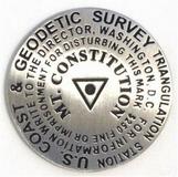
62-9997MC
Mt. Constitution, Orcas Island, Washington paperweight. 2,409 ft.
$59.95
62-8997JE
Mt. Jefferson, Oregon paperweight. 10,497 ft., second highest peak in Oregon.
$59.95
62-8197MM
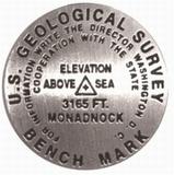
Mt. Monadnock, New Hampshire paperweight. 3,165 ft.
$59.95
62-5697MO
Moro Rock, California paperweight. 6,725 ft., Sequoia National Park.
$59.95
62-8997SN
North Sister peak, Oregon paperweight. 10,085 ft., Oregon.
South Sister peak, Oregon paperweight. 10,358 ft., Oregon.
$59.95
62-6097WM
Washington Monument, D.C. paperweight.
International Benchmark paperweights. Geo-Situ.
$59.95
65-3997MA
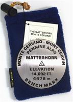
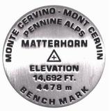
Matterhorn, Switzerland paperweight. 14,692 ft.
$59.95
66-1997VI
Vinson, Antarctica paperweight. 16,067 ft. Highest point on Antarctica.
Benchmark Lapel Pins!
1 inch diameter
Cast in fine pewter
Military clutch back
Mounted on story card
USA Benchmark lapel pins. Geo-Situ.
$11.95
62-8897BLL
Black Mesa, Oklahoma lapel pin. 4,973 ft.
$11.95
63-0297GAL
Gannett Peak, WY lapel pin. 13,804 ft. Highest point in Wyoming.
$11.95
62-9697KIL
Kings Peak, Utah lapel pin. 13,528 ft. Highest point in Utah.
$11.95
62-9997MCL
Mt. Constitution, Orcas Island, Washington lapel pin. 2,409 ft.
$11.95
62-8197MML
Mt. Monadnock, New Hampshire lapel pin. 3,165 ft. The most climbed mountain in North America!
$11.95
62-5697MOL
Moro Rock, California lapel pin. 6725 ft., Sequoia National Park.
$11.95
62-8997SNL
North Sister peak, Oregon lapel pin. 10,085 ft.
$11.95
62-8997SML
Middle Sister peak, Oregon lapel pin. 10,047 ft.
$11.95
62-8397SOL
Socorro Peak, New Mexico lapel pin. 7,226 ft.
$11.95
62-8997SSL
South Sister peak, Oregon lapel pin. 10,358 ft.
$11.95
62-6097WML
Washington Monument, D.C. lapel pin. 555 ft.
$11.95
62-8097WHL
Wheeler Peak, Nevada lapel pin. 13,063 ft.
International Benchmark lapel pins. Geo-Situ.
$11.95
65-3997MAL
Matterhorn, Switzerland lapel pin. 14,692 ft.
USA Benchmark 2-piece lapel pins. Geo-Situ.
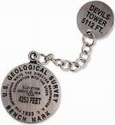
These are older-style two-part lapel pins. These are great for those wanting something a little different in a lapel pin. Some have a small "chain" connecting the two parts of the pin like that illustrated in the "sample" link below. Others do not have that connecting chain.
Thumbnail of the two-part lapel pins.
$11.95
62-5697BADL2
Dante's View, California 2-piece lapel pin, with chain. 5,476 ft.
$11.95
63-0297DEL2
Devil's Tower 2-piece lapel pin, no chain. 5,112 ft.
$11.95
62-5497FCL2
Four Corners AZ/NM/CO/UT 2-piece lapel pin, no chain. 4,862 ft.
$11.95
62-5797EVL2
Mt. Evans, Colorado 2-piece lapel pin, with chain. 5,476 ft.
$11.95
62-5497PRL2
Phantom Ranch Arizona 2-piece lapel pin, no chain.
Benchmark Magnets!
1-1/4 inch diameter
Cast in fine pewter
Strong magnet embedded in back
Mounted on story card
USA Benchmark magnets. Geo-Situ.
$12.95
62-5697BPM
Baden Powell, California magnet. 9,407 ft.
$12.95
62-9997MCM
Mt. Constitution, Orcas Island, Washington magnet. 2,409 ft.
$12.95
62-8397SOM
Socorro, New Mexico magnet. 7,226 ft.
Benchmark Zipper-pulls / pendants!
1 inch diameter
Cast in fine pewter
Lanyard hook attachment
Mounted on story card
USA Benchmark zipper-pulls / pendants. Geo-Situ.
$11.95
62-8897BLZ
Black Mesa, Oklahoma zipper-pull. 4,973 ft.
$11.95
62-9697KIZ
Kings Peak, Utah zipper-pull. 13,528 ft. Highest point in Utah.
$11.95
62-8097CHZ
Mt. Charleston, Nevada zipper-pull. 11,915 ft.
$11.95
62-8197MMZ
Mt. Monadnock, New Hampshire zipper-pull. 3,165 ft.
$11.95
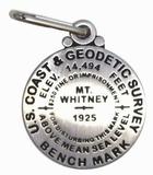
62-5697WHZ
Mt. Whitney, California zipper-pull. 14,494 ft.
$11.95
62-6097WMZ
Washington Monument, D.C. zipper-pull. 555 ft.
Visiting North Carolina? Like to visit Omni? Please click here for a Mapquest map to our offices. If you are passing through central North Carolina, we would be pleased to have you visit our store and warehouse. We are located about 30 minutes east of Greensboro, 60 minutes west of Raleigh, and 2 hours northeast of Charlotte. We are open Monday-Friday 8am - 5:30pm and weekends by prior arrangement.
Contact information: For information on a map or other product: [email protected] To place an order or check on an order: [email protected] For questions on an invoice: [email protected] Phone: (1) 336-227-8300
Fax: (1) 336-227-3748

 City Street Maps for USA Cities. GM Johnson.
 Image of the front of the Reno map.
 Sample detail from the Reno map.

 Sample of the map detail
 Thumbnail image of the map
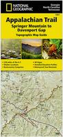
 Sample details from the Appalachian Trail Hiking Map.
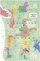
 Image of the Pacific Northwest wine map
 Image of the framed Pacific Northwest wine map
 Sample detail of the Pacific Northwest wine map
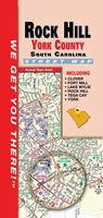 New edition
 New map!
 Image of the Australia wine map
 Image of the framed Australia wine map
 Sample detail of the Australia wine map
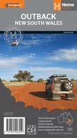
 New map!
 Image of the Austria and Hungary wine map
 Image of the framed Austria and Hungary wine map
 Sample detail of the Austria and Hungary wine map
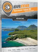 New editions of topographic road atlases for Canada!
 Sample map page from the Vancouver Island Backroads Mapbook
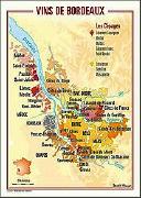
 New map!
 Image of the Germany wine map
 Image of the framed Germany wine map
 Sample detail of the Germany wine map
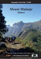 New title
 New title
 Image of the New Zealand wine map
 Image of the framed New Zealand wine map
 Sample detail #1 of the New Zealand wine map
 Sample detail #2 of the New Zealand wine map
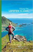 New guide!
 Sample page from the Lofoten hiking guide
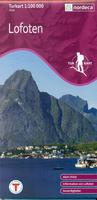 Great companion map!
 Sample page from the Lofoten hiking map
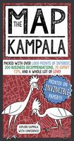 New map!
 Sample details from the Kampala city map.
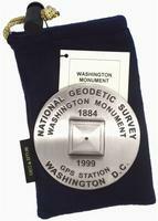


 Thumbnail of the two-part lapel pins.