World Specialty Maps

We stock a huge selection of World Maps, from room-sized wall maps to specialty maps such as World of Coffee maps. Click here to see our complete listing of World Maps.

  • Do you need map pins, map tacks, map pennants/flags to go with your world map? If so click here to see a complete list. Great marker pins, pennants, and flags for marking locations on maps. Multiple colors, multiple styles, numbered pins also available.

    Would you like recommendations? Just call/e-mail us - our experienced staff can offer recommendations for just about any type of world map that you might want.

  • World Travel Map. Folded world road map by Michelin.
  • World Maps for Kids
  • World Cities at Night. This intriguing view shows the location of the world's major cities by their light pollution.
  • World "Upside Down" Wall Maps
  • World of Coffee Map. A maps showing the major coffee-growing regions around the world.
  • World Risk Maps. Shows risky places to travel.
  • World Santa Map.
  • World of Love Map (World Love Map).
  • World Map - Peters Projection
  • Buckminster Fuller Dymaxion & Waterman's Butterfly World Maps.
  • World Population Map
  • World Map of Container Ports

    World Travel Map


    World road map
    World Road Map. 1:28,500,000. Michelin #701. Excellent, folded, road map of the World by this world-renowned publisher. Also available in a flat (and/or laminated) wall map - see World Wall Maps for the flat versions.
    Image of the entire World road map
    Sample of the World road map detail
    Ordering World Travel Map, folded.  (M 701)67-32901 sheet, folded$12.95
    Ordering World wall map, flags  (Mich 12701)67-11031 sheet, flat/rolled$10.95
    Ordering World map w/ flags,  lam. (M 13701)67-1103L1 sheet, laminated$19.95


    World Maps For Kids


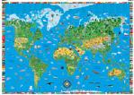
    Children's World Map. Dino's. Illustrated with flags of the world and 450 fun facts. It shows all the continents with illustrations of their natural resources and national costumes. How did people discover far off lands with their indiginous flaura and fauna? Take a look - its a most entertaining and well thought out childrens map, looks good with a flat bright background and the countries, birds animals etc., all UV varnished to stand out and look attractive. This children's map of the world is the most interesting and eye-catching map we have ever seen. Your kids will spend hours looking and studying all the graphics on this map. What's more, they will accidentally learn world geography in the process. This world map is "off the hook" when it comes to awesome graphics. It is perfect for a teenager's room. Be sure to take a look at the close-up to see the detailed pictures used on this map. They are intended to represent the primary activities in that part of the world. The Childrens World Map comes standard with a heavy varnish coating on the front. This coating will allow you to clean the map with a wet paper towel.
    Image of the entire map
    Sample of the map detail
    Ordering Childrens World Map (Dino)67-58021 sheet, rolled.$19.99

    Combo pack with special Pricing!
    Children's World Map & Children's USA Map. Dino's. This twin-pack includes both the Dino's Children' Map of the USA and Dino's Animals of the World map, offered at a special discounted price.
    Sample of the map detail
    Ordering Dinos USA + World Animals two-pack67-5813Rolled.$34.99

    Combo pack with special Pricing!
    Children's World Map, Children's USA Map, and Children's Solar System Map. Dino's. This three-pack includes the Dino's Children' Map of the USA, Dino's World Map, and Dino's Solar System Map, offered at a special discounted price.
    Sample of the map detail
    Ordering Dinos World+USA+Solar System 3-pack67-5814Rolled.$49.99


    Children's Map of the Prehistoric World. Dino's. Dino's all new Illustrated Map of the Prehistoric World includes hundreds of historical, educational, and entertaining points of interest illustrations amazingly drawn by skilled artists combining detailed information and creativity results in one of the most uniquely entertaining maps available. Protected by durable lamination. Map size is approximately 54" x 38."
    Sample of the map detail
    Image of the entire map
    Ordering Childrens Map of Prehistoric World67-58011 sheet, rolled.$19.99


    Animals of the World Map
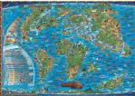
    Dinos Illustrated Map of Animals of the World. Dino's. This delightful world map shows the world's unique and unusual animals in their prime location. Underneath each little figure are basic facts about the animal; size, weight, what it eats, etc. This wonderful map presents a lot of interesting information that has too often been presented in schools as dull facts to be memorized. Size is 38 x 54", shipped rolled.
    Image of the entire map
    Sample of the map detail
    Ordering World Map of Animals (Dino)67-58041 sheet, rolled.$19.99


    Dino's Ancient World Map
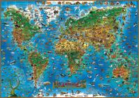
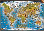
    Dinos Illustrated Children's Map of the Ancient World. Dino's. More than just a map, this is an illustrated look at the 'Ancient World!' Create by DinosMaps, this map of the Ancient World includes illustrations about ancient cultures, civilizations, explores, pirates, myths and legends. Explore as you've never done before! Learn about ancient world and places. Not only does this illustrated ancient world map appeal in a very big way to children - It's credible, complete, meaningful content appeals to those young at heart as well. Over 600 hand drawn colorful and engaging icons, complete with informative text - covering everything from ancient structures; competitions; natural wonders; ships and vessels; famous people, ancient inventions, and legends. Size is 38 x 54", shipped rolled.
    Image of the entire map
    Sample of the map detail
    Ordering Childrens Map of the Ancient World67-58071 sheet, rolled.$14.99


    Kids Illustrated World Map
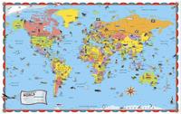
    Kids Illustrated World Map. Rand McNally. Rand McNally's Illustrated World Wall Map is fun and colorful and is sure to brighten up any bedroom or playroom. Laminated for durability, the map has hundreds of illustrations of animals, major landmarks, and natural features, and comes with a book filled with fun facts about the world. Has a thin lamination on the front. Size is 50 x 32", shipped rolled.
    Image of the entire map
    Sample of the map detail
    Ordering Kids illustrated World Map (RM)67-58081 sheet, rolled.$14.95


    World Cities at Night Map


    World Cities At Night. Raven.
    Thumbnail image
    Sample detail
    Ordering World Cities at Night  (Raven)67-10461 sheet, rolled$30.00
    Ordering World-Cities at Night (R)67-1046LLaminated$50.00


    World Upside Down Wall Maps


    "Upside Down" World Map. This map has the world turned upside down to give a different perspective on the world. The map has shaded relief to show mountain ranges; each country is colored differently and the map has several comparative world views along the bottom. The map is Africa-centered. Available either folded or as a laminated wall map. Size is 36½ x 56½ inches.
    Thumbnail image of whole map
    A detail from the map
    Ordering Upside-Down World Map, folded67-11111 sheet, folded$20.00
    Ordering Upside-Down World Map laminate (ODT67-1111LLaminated$25.00


    World Upside Down map
    World Upside-down Map - Original and classic version. ODT. Imported from Australia and laminated in the USA. Unique downunder viewpoint with cheeky Aussie humor. This map was created by Stuart McArthur of Melbourne, Australia. He drew his first South-Up map when he was 12 years old (1970). His geography teacher told him to re-do his assignment with the "correct" way up if he wanted to pass. Three years later he was an exchange student in Japan. He was taunted by his exchange student-friends from the USA for coming from "the bottom of the world." It was then, at age 15, he resolved to one day publish a map with Australia at the top. Six years later, while at Melbourne University, he produced the world's first "modern" south up map and launched it on Australia day in 1979.
    Image of the entire World upside-down map
    Ordering McArthurs Upside-Down World Map.67-11121 sheet, flat$29.99


    "Upside Down" World Map. Hema, 2006. This map has the world turned upside down to give a different perspective on the world. Size is 84 x 60 cm.
    Sample detail of the Upside down world map
    Thumbnail image of whole map
    Ordering Folded World Upside Down Map (Hema)67-105181 sheet, folded$12.99
    Ordering World Upside Down (Hema) Flat.67-105181Flat.$13.99
    Ordering World Upside Down Map.  Laminated67-105181LFlat, laminated.$26.95


    World Specialty Maps


    The World of Coffee map. No scale. Oxford Cartographers, 1998. On the front is a map of the world with symbols showing consumption, export, and import quantities. The reverse side has text and photos on the history of coffee; coffee types; growing, producing preparing, and brewing coffee. Folded, size is 24 x 32 inches unfolded.
    Thumbnail of the entire map
    Detail of the map
    Ordering World of Coffee map67-21021 sheet, folded$13.99


    World Risk Map. No scale. Pinkerton Global Intelligence Service & Maplink, 1999. This map shows the level of risk around the world, as calculated by Pinkerton's. The map also shows health risks and offers basic travel security tips. The reverse side lists the locations of all foreign embassies in the USA, their country's risk level, and any special passport or visa requirements.
    Detail of the map.
    Ordering World Risk map67-21041 sheet, folded$8.95


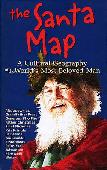
    The World Santa Map. Hedberg Maps. Your family will love tracing Santa's travels across time and continents with this giant fold-out map. The Santa Map surveys the magic of the eternal winter visitor, unraveling the mystery - and the history - of old St. Nick. One side includes a history of Santa in all his names and guises. The other side has a world map with numerous notes on how countries celebrate Christmas around the world.
    Ordering World Santa Map67-21051 sheet, folded$9.95


    The World of Love Map (World Love Map). Hedberg Maps. A glimmer, a spark, a blaze of passion, it's a tale as old as the human race. The story of romance - its changes through time and its variations around the globe - is lovingly told in this lushly illustrated giant map. Available either folded or flat/laminated, the map measures 39 x 26.5".
    Image of the front of the World Love map
    Image of the reverse of the World Love map
    Sample #1 of the World Love Map detail
    Sample #2 of the World Love Map detail
    Sample #3 of the World Love Map detail
    Ordering World of Romance map (Love Map)67-21081 sheet, folded$9.95
    Ordering World of Romance map (Love Map)67-2108L1 sheet, folded$9.95


    Buckminster Fuller Dymaxion & Waterman's Butterfly World Wall Maps


    Buckminster Fuller Dymaxion map
    Buckminster Fuller Dymaxion Map. ODT. This Raleigh Edition of the Dymaxion (TM) map, first designed in Raleigh, North Carolina, is a vivid color reproduction of the original rendition created by R. Buckminster Fuller in 1954 in his office there. We have reproduced the map exactly as it was first conceived and produced by its creator. Both the land masses and the grayscale shading in the oceans represent mean low annual temperatures. The visionary Fuller designed this map to help us recognize that ''we're all astronauts aboard a little spaceship called Earth.'' Because it can be reconfigured into a variety of patterns, it also communicated the point that "there are many ways to see the world." Size is 23 x 34", available either folded or flat/laminated.
    Image of the entire map
    Ordering Buckminster Fuller Dymaxion World67-10527Folded$21.99
    Ordering Buckminster Fuller Dymaxion World67-10527LFlat, laminated$29.99


    Buckminster Fuller Dymaxion map
    Buckminster Fuller Dymaxion Map Placemats. ODT. This Raleigh Dymaxion (TM) map is a desktop version at 1/4th of the size of the 22''x34'' full-size version listed just above. It is perfect for a student desktop map, as it shows the sizes and shapes of the continents accurately. This size makes a snappy addition to your breakfast table as an exciting placemat. It's educational, as it has a lengthy explanation printed on the reverse side. The text on the map (being reduced in size) is hard to read, but the desktop version has the same vivid colors of the original. Size is 11 x 17", laminated.
    Image showing the front and back of the placemat
    Ordering Bucky Fuller Dymaxion placemat67-10527PSingle placemat$8.95
    Ordering Bucky Fuller Dymaxion placemat set67-10527PSSet of four placemats$26.85


    Waterman's Butterfly Dymaxion map
    Waterman's Butterfly World Map. Waterman/ODT. This is the most exciting and beautiful map we've seen in quite a while. It is a 14-sided polyhedral projection addressing both distortion and partitioning of land masses. The butterfly layout combines legibility and low distortion. Size is 26 x 38".
    Image showing the front and back of the Waterman Butterfly Map.
    Ordering Waterman Butterfly World Map67-105191 sheet, flat$14.99


    Peters Projection (Equal Area) World Wall Maps


    World Peters Projection Map. 1:25,000,000. ODT, 2002. The Peters Projection World Map is one of the most stimulating, and controversial, images of the world. When this map was first introduced by historian and cartographer Dr. Arno Peters at a Press Conference in Germany in 1974 it generated a firestorm of debate and it continues to have passionate fans as well as staunch detractors, as noted in its portrayal on The West Wing tv show. The earth is round. The challenge of any world map is to represent a round earth on a flat surface. There are literally hundreds of map projections. Each has certain strengths and corresponding weaknesses. Choosing among them is an exercise in values clarification: you have to decide what's important to you. That is generally determined by the way you intend to use the map. The Peters Projection is an area accurate map, meaning the sizes of each land mass is accurate in relation to each other. Available as a folded map or a laminated wall map. Size is 35" x 52".
    Ordering World Map Peters Projection folded67-10511Folded map.$14.95
    Ordering World Peters Projection:  paper67-10511PFlat paper wall map.$28.00
    Ordering World Map Peters Proj., lam. (ODT)67-10511LLaminated wall map.$29.95


    Peters Pacific-Centered Equal-Area World Map. ODT, Inc. A Pacific-centered, equal-area world map. The map shows accurate sizes and proportions - see how big Greenland really is compared to the USA. Pacific-centered to show the true dimensions of the Pacific Ocean. Folded, overall size is 20½ x 32".
    Thumbnail of the whole map
    Ordering World Peters Projection, Pac-center67-105231 sheet, folded. Size is 20½ x 32".$9.95


    Equal-area World Placemat. ODT, Inc. This attractive placemat/map is printed on both sides! The image on one side is North-up, Africa in the center. Turn the map over and you see the EXACT same map with different orientation and different centering: South-up and Australia center-top! Size is 11 x 17" (28 x 43 cm.).
    Front side of the placemat
    Reverse side of the placemat
    Ordering World equal-area placemat, laminate67-93943Placemat.$8.95
    Ordering World equal-area placemat, set of 467-93943SPlacemat 4-set - buy 3, get one free.$29.85


    World Population Map


    World Population Map. ODT, Inc., 2004. The Population Map shows the world in an entirely new light! See where the human beings of the world live, and how many are where. The map image is startling, provocative and BEAUTIFUL. Each country is shown proportional to its population. The map presents people, not territory. Each square of the grid on the map represents a million people. From the perspective of population, China is the biggest country in the world! India is not far behind. For a real shock, compare Indonesia with the United States. This map shows how the USA is only a small part of the whole, 4.5% or less than one-twentieth of the Earth's humans. The main map is enhanced by a series of startling and informative images at the bottom: Population, by continent, throughout human history. This series of "snapshot" images shows the people, and where they were at (1) 100,000 years ago, (2) at the time of the birth of Christ, (3) at 1650 AD, (4) at 1900 AD, and includes (5) population projections for the year 2150. There is also a map of population density showing where there are more than 30 people per square mile. In contrast to the usual continents of land, this density image shows the continents and islands of humankind!
    Image of the full map
    Ordering World Population Map (ODT) - Lam.67-1062LFlat, laminated.$29.99


    World Map of Container Ports


    World Ports map
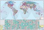
    World Map of Container Ports - wall map. 53" x 77". It is a premium quality map designed as a decorative office resource for a wall or boardroom environment. The map is printed on one side and one sheet of paper. It features a large scale global projection as well as detailed inset maps. In addition, over 1100 container ports are indexed, plotted and categorized, by annual container throughput as well as 322 airports with IATA codes are indexed and plotted.
    Thumbnail image of the map
    Ordering World Ports Map, wall edition67-21070Wall map$99.99


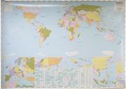
    Desktop World Map of Container Ports - small edition. 27 x 39". This small version is designed for forwarders and traffic managers and for professionals managing large volumes of containers. The map is printed on two sides featuring a global projections as well as detailed inset maps. In addition over 1100 container ports are indexed, plotted and categorized, by annual container throughput. Furthermore, over 900 Port Authority websites are indexed in a supporting table.
    Thumbnail image of the map
    Ordering World Container Ports Map, folded.67-21071Map, folded$9.95
    Ordering World Ports Map, laminated.67-21071LMap, laminated$16.99


    World Coconuts and Oil Palms: World Production and Consumption. 1:40,000,000. OSD (3275). 1992.
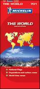
    Ordering World Coconuts and Oil Palms67-10651 sheet, rolled$5.95


    image

  • © Copyright 2007 Omni Resources All Rights Reserved
    For more information please Contact Us