In English Japan Road Atlas. 1:850,000. ITMB. The maps show highways, major and secondary roads, ferry routes, airports, shinkansen, privatised and Japanese railway lines, etc. Symbols denote points of interest such as national parks, temples, resorts, and cultural and physical heritage sights. Topography is shown with elevation tinting and with selected spot heights. Administrative and international boundaries are shown.
The rest of the atlas includes regional and city mapping at varying scales, including: Tokyo, Kyoto, Nara, Osaka, and Kobe. The city maps show expressways, major, secondary, and minor roads, as well as rail lines and stops for multiple rail networks, such as subways, shinkansen, trams, monorail etc. City maps also include district names and zones highlighted in light grey. Subway maps are also included for each city enlarged in the atlas.
Sample from the Japan atlas
$19.95
64-85901
Pocket atlas.
In Japanese only All-Japan Road Atlas. 1:200,000 & 1:300,000 (Hokkaido). Shobunsha.
A detailed road atlas of Japan; 8.25 x 11.75 inches, paperback, 362 pages. The map shows contour lines, distances between major intersections and symbols for everything from stoplights to ski lifts, golf courses, tourist sites and services, and much more.
With a 3-minute latitude/longitude grid.
In Japanese only.
Sample detail of the All-Japan Road Atlas
$44.99
64-85893
Atlas.
In Japanese only Tokyo Master Street Atlas. 1:10,000. Shobunsha.
A detailed street atlas of Tokyo; 8.25 x 11.75 inches, paperback, 490 pages. The map shows contour lines only in the non-populated areas on the edges of Tokyo. The maps show building and block numbers and use symbols for everything from stoplights to movie theatres, and to popular chain stores such as Circle-K and 7-11.
With a 30-second latitude/longitude grid.
In Japanese only.
Sample detail of the Tokyo Street Atlas
$42.99
64-8594TM
Atlas.
Japan Travel Maps
Waterproof! Japan Travel Map. 1:1,100,000. ITMB.
Printed on waterproof paper. The map shows roads, parks, accommodations, attractions/points of interest, temples, elevation, and hydrography. This is the largest-scale of the various road maps of Japsan.
Sample detail from the Japan map Sample detail from the Japan map
$12.95
64-85918
1 sheet, folded.
Paper map Japan Travel Map. 1:1,300,000. Freytag & Berndt.
Road detail concentrates mostly on motorways and main roads and indicates intermediate driving distances. Railways and ferry routes are shown, and symbols depict ports, airports, volcanos, mountain peak heights, spas, beaches, tourist sights, wintersport locations and temples. National parks are indicated, also Sub-Prefecture, Prefecture and District boundaries.
An inset map shows major air connections throughout the country, and on the reverse is a table of administrative divisions and the index, which includes geographical features as well as settlements. Map size is 27 x 39" (68 x 99 cm).
$13.99
64-85910
1 sheet, folded
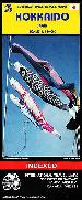
Japan North and Hokkaido Travel Map. 1:800,000. ITMB.
A hypsometric physical map of the northern Japanese island of Hokkaido. Fully indexed, with tourist information and sites. A good tourist map, although not as detailed as we would like. In English.
$12.95
64-85921
1 sheet, folded
Japan South Travel Map. 1:670,000. ITMB.
Japan divides nicely into north of Tokyo and south. This map covers the popular Tokyo to Osaka Route, and west to Hiroshima and south all the way to Kagoshima, the end of the Shinkansen rail network. Japan is seen as being a smallish country, but is densely populated, so having a map at this scale allows is to open up the information and show its many attractions more easily. The map also includes insets of the most southerly island chains of Okinawa, Senkaku and Sakishima, as wall as city insets of Kyoto, Nara and Osaka.
Thumbnail of the front of the map Thumbnail of the reverse of the map
$12.95
64-85922
1 sheet, folded.
In Japanese only National Road Map of Japan. Shobunsha, 2014.
The map is a simple, slightly stylized, road map that shows all of the national roads of Japan, with route numbers. The map expands to a long strip map of approx. 1 x 10 ft. The map uses mountain symbols to show mountain ranges, etc. Hundreds of little images highlight tourist sites throughout the country, including hot springs, volcanoes, historic villages, and much more. Hundreds of symbols locate tourist facilities, each with a telephone number. Also includes a booklet with additional information about the tourist facilities marked on the map. In Japanese only.
Sample detail from the Japan national road map
$12.99
64-85909
1 sheet, folded.
Japan & Tokyo Rail Maps
National Rail Map of Japan. Shobunsha, 2011/2014.
Comprehensive map,in Japanese, of the various JR (JapanRail) railway lines in the country. This map expands to a long map of approx. 1 x 10 ft. On the back of the map are detailed maps of the various major cities with their bus / train / metro and boat networks. Also includes a booklet with information about local transportation and various practical tourist information. In Japanese only.
Rail Map of Tokyo. Shobunsha, 2011/2014.
Comprehensive Japanese map of the various railway lines of JR in the country. This card in this guide is to expand to a long map of more than 3 meters long. On the back of the card are detailed maps of the various major cities with their bus / train / metro and boat network. Also includes a booklet with information about the various models trains, local transportation and various practical tourist information. In Japanese!
Sample detail from the Tokyo rail map
$12.99
64-8594TS
1 sheet, folded.
English-language Japan City Street Maps
Listed below are English-language or bilingual city plans for Tokyo, Kyoto, Nara, and Osaka.
Kyoto and Japan South Map. 1:12,500 / 1:1,100,000. ITMB.
This map has a map showing the central district of Kyoto at 1:12,500 on one side and a map showing the southern area of Japan at 1:1,100,000 on the reverse. On the Kyoto map, metro stations are shown with names and locations of their entrances. Railway stations indicate the train type - Shinkanses, Japan Rail or private. Also shown is the tramline from the Shijo-Omiya terminal. The main routes are highlighted for drivers and one way streets are marked. Symbols denote places of interest including Shinto shrines, Buddhist Temples, museums, leisure facilities, selected hotels, shopping centers, etc.
The index lists only selected main streets plus districts and zones. There is also a list of temples and shrines. Inset maps include a diagram of the metro network, a map of the city's environs showing access to Nara and Osaka, plus a street plan of central Nara, similar to the Kyoto map.
The regional map of southern Japan has coverage starting well north of Tokyo. The southern islands, including Okinawa, are shown in several inset maps. The map shows road and rail networks, indicating toll routes and different types of railway lines, and includes ferry connections. Elevation is shown by relief shading. The map is indexed and has a 1° latitude and longitude grid.
Sample of the map detail
$12.95
64-8594KS
1 sheet, folded
Osaka & Western Japan Travel Map. 1:12,500 & 1:670,000. ITMB.
Osaka, as a city, offers one of the world's great treasures - its majestic castle. The city is one of the largest urban areas in Japan and offers a wide range of attractions. The local rapid transit route map is shown on the back cover. The regional map, at an easy-to-use 670,000 scale covers the main island of the country from just west of Tokyo through Nagoya and Kyoto to Matsue in the north and Matsuyama in the south. To further assist users, a small inset map of the greater Tokyo area from Narita airport to central Tokyo has been included. The rail network is well-shown, with the famous Shinkansen lines differentiated.
Sample detail from the Osaka City Map Sample detail from the Osaka City Map
$10.95
64-8594OK
1 sheet, folded.
Laminated Tokyo Laminated City Map. 1:17,000. Borch.
Laminated city-center/tourist map. The main map covers Tokyo at 1:17 000, while inset maps on the reverse cover Tokyo Bay & Shinagawa at 1:19 000, Greater Tokyo at 1:1,300,000, the Tokyo Subway Route Map, Japan administrative and time zones, and Top 30 Sights.
Sample of the Tokyo map detail Front of the Tokyo map Reverse of the Tokyo map
$9.95
64-8594TF
1 sheet, folded
Waterproof! Tokyo and Central Japan Map. 1:15,000 / 1:800,000. ITMB.
This map has a map of the central district of Tokyo at 1:15,000 and a map on the reverse showing the central area of Japan at 1:800,000. The Tokyo map is a street map showing the division of districts into zones and blocks. Metro and other public transport stations are marked, and line numbers are noted. Extensive range of symbols highlight facilities, places of interest and institutions, including selected hotels, department stores and shopping centers, embassies, religious temples and shrines, water taxi stops, and much more.
Tokyo generally does not use street names, so the street index is very short. There is an index of metro stations, district names, and a metro map.
The regional road map covers central Japan (central Honshu) including Osaka, Kyoto, and Tokyo. showing road connections and railway lines and administrative boundaries with names of districts. Elevation is shown by color tinting plus spot heights. National parks and protected areas are highlighted, including Mount Fuji, and various shrines and other places of interest marked by symbols. The map is indexed and has a 1° latitude and longitude grid.
Sample of the map detail Sketch map showing area covered by the map
$10.95
64-8594TI
1 sheet, folded
Rail Map of Tokyo. Shobunsha, 2011/2014.
Comprehensive Japanese map of the various railway lines of JR in the country. This card in this guide is to expand to a long map of more than 3 meters long. On the back of the card are detailed maps of the various major cities with their bus / train / metro and boat network. Also includes a booklet with information about the various models trains, local transportation and various practical tourist information. In Japanese!
Sample detail from the Tokyo rail map
Sample of the Nagasaki city map. We now stock city maps of over 500 Japanese Cities. These maps, produced by Shobunsha, are in Japanese only. A few maps covering the larger cities and/or tourist destinations, such as Nagasaki and Hiroshima, have some English on the maps.
Mt. Fuji Benchmark Paperweight
Mt. Fuji Benchmark Paperweight. 3776 meters. Geo-Situ.
If you have not climbed Mt. Fuji to watch the sun rise, then you've got the perfect excuse to go to Japan. Once you come back, this benchmark paperweight is the ideal reminder of what you accomplished! Mt. Fuji has Japans official designation as A Special Place of Scenic Beauty. In 2013 it was added to UNESCOS World Heritage List.
Translation of Japanese lines on the paperweight, from top to bottom:
Japan Hiking Maps for Mt. Fuji and additional locations
Mt. Fuji Hiking Map. 1:50,000. Shobunsha.
If you have not climbed Mt. Fuji to watch the sun rise, then you've got the perfect excuse to go to Japan. This is a detailed hiking and topographic map of Mt. Fuji is all the map that you need for the climb. The front side of the map is the main map at 1:50,000, showing the road access to the mountain, the hiking trails and the hiking time needed both up and down the mountain, and numerous symbols showing tourist services, etc. The reverse side has a 1:25,000 map of the mountain showing the closest auto access and the main hiking trails.
Three inset maps ranging from 1:50,000 to 1:300,000 show other parts of the region. Although the map is in Japanese, the main trails and access towns are labeled in English on both the 1:50,000 and 1:25,000 maps thus this map is perfectly usable for an English-speaking tourist.
Sample detail of the Mt. Fuji map
$13.99
64-8575-32
Folded
Japan Hiking Map Series. 1:50,000. Shobunsha.
Detailed topographic maps of the most popular hiking areas in Japan. There is a main area map at 1:50,000 on one side of the map. The reverse side usually has a regional map at a smaller scale such as 1:200,000 plus detailed maps of the individual mountain peaks at scales of 1:25,000 or so. The maps show typical hiking times along each trail. Unfortunately these maps are in Japanese only. We supply an English translation of the map legend. All maps in the series were updated in 2013 or more recently.
Sample detail from the Mt. Fuji map. Sample detail from the Central Japanese Alps map.
#47 - Kitayama Mountains hiking map. Popular area just outside Kyoto.
$13.99
64-8575-48
#48 - Hokusetsu area hiking map.
$13.99
64-8575-49
#49 - Mt. Maya & Mt. Rokko hiking map. 1:25,000.
$13.99
64-8575-50
#50 - Mt. Kongo hiking map. The main peak of the Kongo-Katsuragi mountain range.
$13.99
64-8575-51
#51 - Mt. Omine, Mt. Hachigyogatake, and Mt. Shakagatake hiking map. Includes Yoshino-Kumano National Park on the Kii Peninsula.
$13.99
64-8575-52
#52 - Mt. Takami hiking map.
$13.99
64-8575-53
#53 - Mt. Hyonosen & Mt. Hachibuse hiking map.
$13.99
64-8575-54
#54 - Daisen-Hiruzen Plateau hiking map. Includes coverage of Daisen-Oki National Park.
$13.99
64-8575-55
#55 - Mt. Ishizuchi & Mt. Tsurugi hiking map. A popular area on Shikoku.
$13.99
64-8575-56
#56 - Northern Kyushu hiking map. Covers several areas in northern Kyushu. 1:25,000 & 1:50,000.
$13.99
64-8575-57
#57 - Mt. Aso hiking map. Includes Aso-Kuju National Park on Kyushu.
$13.99
64-8575-58
#58 - Mt. Okueyama hiking map. Northern Kyushu.
$13.99
64-8575-59
#59 - Mt. Kaimondake hiking map. Spectacular active volcanos in southern Kyushu.
$13.99
64-8575-60
#60 - Mt. Miyanouradake & Yakushima Island hiking map.
Japan Topographic Maps
Japan Topographic Map Series Index Map.Japan 1:25,000 - 1:200,000 index map. NOTE: 7 meg file. This index map is a very large (2 x 3 foot) index showing a combined 1:25,000 through 1:200,000 index map on a single sheet.
Japan Topographic Quadrangle Maps. 1:25,000. Geographical Survey Institute. Complete coverage is available in 4,455 sheets. In Japanese.
$14.95
64-85493
Per sheet
Iwo Jima 1:25,000 Topographic Map. 1:25,000. Geographical Survey Institute. In Japanese.
$14.95
64-8549-1
1 sheet, rolled
Okinawa 1:25,000 Topographic Maps. 1:25,000. Geographical Survey Institute. In Japanese. Complete coverage of the island in 32 sheets.
$320
64-8549-2
Set of 32 sheets, rolled
Okinawa 1:50,000 Topographic Maps. 1:50,000. Geographical Survey Institute. Complete coverage of the Okinawa in 13 sheets; not as detailed as 64-8549-2 above. In Japanese.
$130
64-8549-3
Set of 13 sheets, rolled
Japan Topographic Quadrangle Maps. 1:50,000. Geographical Survey Institute. Complete coverage is available in 1,249 sheets. In Japanese.
$14.95
64-85495
Per sheet
Japan Topographic Quadrangle Maps. 1:200,000. Geographical Survey Institute. This set of 130 sheets offers complete coverage of Japan. In Japanese. Sheet size is 80 x 109 cm. *English translation of the legends included.
Japan 1:200,000 Index.
$14.95
648550NJ5422
NJ 5422
$14.95
648550NJ5423
NJ 5423
$14.95
648550NG5105
NG 51 05-06-11-12, Miyakojima
$14.95
648550NG5110
NG 51 10-16, Uotsurishima
$14.95
648550NG5112
NG 51 12-18-24, Ishigakijima
$14.95
648550NG5219
NG 52 19, Tokunoshima
$14.95
648550NG5220
NG 52 20-26, Yoronjima
$14.95
648550NG5221
NG 52 21-27, Naha
$14.95
648550NG5227
NG 52 27-33, Kumejima
$14.95
648550NG5408
NG 54 08-09, Ogasawarashoto
$14.95
648550NH5201
NH 52 01, Miyazaki
$14.95
648550NH5203
NH 52 03-09, Yakushima
$14.95
648550NH5207
NH 52 07, Kagoshima
$14.95
648550NH5208
NH 52 02-08, Kaimondake
$14.95
648550NH5213
NH 52 13, Koshikijima
$14.95
648550NH5214
NH 52 14, Kuroshima
$14.95
648550NH5216
NH 52 16, Nakanoshima
$14.95
648550NH5217
NH 52 17, Takarajima
$14.95
648550NH5218
NH 52 18, Amami Oshima
$14.95
648550NI5202
NI 52 02, Mishima
$14.95
648550NI5203
NI 52 03, Yamaguchi
$14.95
648550NI5204
NI 52 04, Makatsu
$14.95
648550NI5205
NI 52 05, Oita
$14.95
648550NI5206
NI 52 06, Nobeoka
$14.95
648550NI5209
NI 52 09, Ogushi
$14.95
648550NI5210
NI 52 10, Fukuoka
$14.95
648550NI5211
NI 52 11, Kumamoto
$14.95
648550NI5212
NI 52 12, Yatsushiro
$14.95
648550NI5214
NI 52 14, Izuhara
$14.95
648550NI5216
NI 52 16, Karatsu
$14.95
648550NI5217
NI 52 17, Nagasaki
$14.95
648550NI5218
NI 52 18, Nomozaki
$14.95
648550NI5223
NI 52 23, Fukue
$14.95
648550NI5224
NI 52 24, NH 52 19, Tomie
$14.95
648550NI5301
NI 53 01, Iida
$14.95
648550NI5302
NI 53 02, Toyohashi
$14.95
648550NI5303
NI 53 03, Iragomisaki
$14.95
648550NI5307
NI 53 07, Gifu
$14.95
648550NI5308
NI 53 08, Nagoya
$14.95
648550NI5309
NI 53 09, Ise
$14.95
648550NI5310
NI 53 10, Kinomoto
$14.95
648550NI5313
NI 53 13, Miyazu
$14.95
648550NI5314
NI 53 14, Kyoto & Osaka
$14.95
648550NI5315
NI 53 15, Wakayama
$14.95
648550NI5316
NI 53 16, Tanabe
$14.95
648550NI5319
NI 53 19, Tottori
$14.95
648550NI5320
NI 53 20, Himeji
$14.95
648550NI5321
NI 53 21, Tokushima
$14.95
648550NI5322
NI 53 22, 23 Tsurugisan
$14.95
648550NI5325
NI 53 25, Matsue
$14.95
648550NI5326
NI 53 26, Takahashi
$14.95
648550NI5327
NI 53 27, Okayama & Marugame
$14.95
648550NI5328
NI 53 28, Kochi
$14.95
648550NI5329
NI 53 29, Kubokawa
$14.95
648550NI5335
NI 53 29-35, Uwajima
$14.95
648550NI5331
NI 53 31, Taisha
$14.95
648550NI5332
NI 53 32, Hamada
$14.95
648550NI5333
NI 53 33, Hiroshima
$14.95
648550NI5334
NI 53 34, Matsuyama
$14.95
648550NI5419
NI 54 19, Chiba
$14.95
648550NI5420
NI 54 20, Otaki
$14.95
648550NI5425
NI 54 25, Tokyo
$14.95
648550NI5426
NI 54 26, Yokosuka
$14.95
648550NI5427
NI 54 27, Miyakejima
$14.95
648550NI5428
NI 54 28-34, Hikurajima
$14.95
648550NI5429
NI 54 29, Hachijojima
$14.95
648550NI5431
NI 54 31, Kofu
$14.95
648550NI5432
NI 54 32, Shizuoka
$14.95
648550NI5433
NI 54 33, Omaezaki
$14.95
648550NJ5304
NJ 53 04-10, Wajima
$14.95
648550NJ5305
NJ 53 05, Toyama
$14.95
648550NJ5306
NJ 53 06, Takayama
$14.95
648550NJ5311
NJ 53 11, Nanao
$14.95
648550NJ5312
NJ 53 12-18, Kanazawa
$14.95
648550NJ5330
NJ 53 30-36, Saigo
$14.95
648550NJ5407
NJ 54 13, Morioka
$14.95
648550NJ5414
NJ 54 14, Ichinoseki
$14.95
648550NJ5415
NJ 54 15, Ishinomaki
$14.95
648550NJ5416
NJ 54 16, Akita
$14.95
648550NJ5417
NJ 54 17-23, Shirakawa
$14.95
648550NJ5419
NJ 54 19, Akita
$14.95
648550NJ5420
NJ 54 20, Shinjo
$14.95
648550NJ5421
NJ 54 21, Sendai
$14.95
648550NJ5424
NJ 54 24, Mito
$14.95
648550NJ5425
NJ 54 25, Oga
$14.95
648550NJ5426
NJ 54 26, Sakata
$14.95
648550NJ5427
NJ 54 27, Murakami
$14.95
648550NJ5428
NJ 54 28, Niigata
$14.95
648550NJ5429
NJ 54 29, Nikko
$14.95
648550NJ5430
NJ 54 30, Utsunomiya
$14.95
648550NJ5433
NJ 54 33, Aikawa
$14.95
648550NJ5434
NJ 54 34, Nagaoka
$14.95
648550NJ5435
NJ 54 35, Takada
$14.95
648550NJ5436
NJ 54 36, Nagano
$14.95
648550NK5401
NK 54 01, Kitami
$14.95
648550NK5402
NK 54 02, Obihiro
$14.95
648550NK5403
NK 54 03, Hiroo
$14.95
648550NK5407
NK 54 07, Asahikawa
$14.95
648550NK5408
NK 54 08, Yubaridake
$14.95
648550NK5409
NK 54 09, Urakawa
$14.95
648550NK5413
NK 54 13, Rumoi
$14.95
648550NK5414
NK 54 14, Sapporo
$14.95
648550NK5415
NK 54 15, Tomakomai
$14.95
648550NK5416
NK 54 16, Shiriyazaki
$14.95
648550NK5417
NK 54 17, Noheji
$14.95
648550NK5418
NK 54 18, Hachinohe
$14.95
648550NK5419
NK 54 19-20, Iwanai
$14.95
648550NK5421
NK 54 21, Muroran
$14.95
648550NK5422
NK 54 22-28, Hakodate
$14.95
648550NK5423
NK 54 23-29, Aomori
$14.95
648550NK5424
NK 54 24, Hirosaki
$14.95
648550NK5426
NK 54 26-27, Kudo
$14.95
648550NK5428
NK 54 28, Oshima Oshima
$14.95
648550NK5430
NK 54 30, Fukaura
$14.95
648550NK5519
NK 55 19, Shikotanto
$14.95
648550NK5525
NK 55 25, Shibetsu
$14.95
648550NK5526
NK 55 26, Nemuro
$14.95
648550NK5531
NK 55 31, Shari
$14.95
648550NK5532
NK 55 32, Kushiro
$14.95
648550NL5406
NL 54 06, Monbetsu
$14.95
648550NL5410
NL 54 10-16-22, Wakkanai
$14.95
648550NL5411
NL 54 11, Esashi
$14.95
648550NL5412
NL 54 12, Nayoro
$14.95
648550NL5417
NL 54 17, Teshio
$14.95
648550NL5418
NL 54 18, Haboro
$14.95
648550NL5510
NL 55 10, Shibetoro
$14.95
648550NL5511
NL 55 11, Bettobu
$14.95
648550NL5517
NL 55 17, Shana
$14.95
648550NL5518
NL 55 18, Urumonbetsuko
$14.95
648550NL5524
NL 55 24, Atoiyamisaki
$14.95
648550NL5530
NL 55 30, Shiretokomisaki
$14.95
648550NL5536
NL 55 36, Abashiri
$814.45
64-8551
Set of 130 sheets
Japan Topographic Quadrangle Maps. 1:500,000. Geographical Survey Institute. Eight sheets offer complete coverage. Elevations are in English with place names in Japanese. Sheet size is 80 x 109 cm.

 In English
 Sample from the Japan atlas
 In Japanese only
 Sample detail of the All-Japan Road Atlas
 In Japanese only
 Sample detail of the Tokyo Street Atlas
 Waterproof!
 Sample detail from the Japan map
 Sample detail from the Japan map
 Paper map


 Thumbnail of the front of the map
 Thumbnail of the reverse of the map
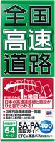 In Japanese only
 Sample detail from the Japan national road map
 Sample detail from the Japan rail map
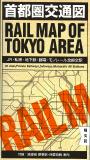
 Sample detail from the Tokyo rail map
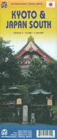
 Sample of the map detail
 Sample detail from the Osaka City Map
 Sample detail from the Osaka City Map
 Laminated
 Sample of the Tokyo map detail
 Front of the Tokyo map
 Reverse of the Tokyo map
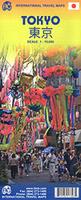 Waterproof!
 Sample of the map detail
 Sketch map showing area covered by the map
 Sample of the Nagasaki city map.
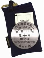
 Image of the Mt. Fuji benchmark paperweight
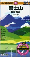
 Sample detail of the Mt. Fuji map
 Sample detail from the Central Japanese Alps map.


 Japan 1:25,000 - 1:200,000 index map.

 Japan 1:200,000 Index.