|
|
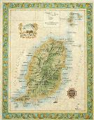
Grenada & Grenadines Topographic Quadrangle Maps. 1:25,000. 1969-1988. DOS (342, 344), Britain. This 4-sheet map offers coverage of Grenada and the Grenadines. Sheet size varies, approx. 75 x 95 cm. Two sheets cover Grenada, one sheet covers Ronda, and one sheet covers Carriacou. Note that some of these sheets are out of print and only available as color plots or as digital raster files (scans of the original paper maps).
Carriacou Topographic Map. 1:10,000. OS. Three sheets give complete coverage.
|
||||||||||||||||||||||||||||||||||||||||||||||||||||||||||||||||||||||||||
 Grenada Maps
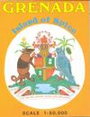
 Sample of the map detail.