One Treasure Limited publishes antique style maps and charts, capturing an old world style but offering current geographical information. The maps are printed on parchment paper and frame beautifully. Please contact us if you should have any questions. We can assure you that they are more beautiful in person.
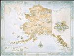
Alaska. 30 x 20". Alaska was admitted to the Union as the 49th state. Known as "The Last Frontier" it is the largest state in area, covering 570,374 square miles. Purchased from Russia in 1867 for $7.2 million, at first Alaska was called "Seward's Folly" after the Secretary of State who engineered its acquisition. The "folly" turned into a bargain when gold was discovered in the Klondike in 1896. Site of Mount McKinley, the highest peak in North America, Alaska is famous for its national parks, abundant wildlife and vast expanse of wilderness.
$25.00
62-53491
1 sheet, rolled.
Antigua. 23 x 28".
A British colony since 1632, Antigua was granted independence in 1981. Located in the Leeward Islands of the West Indies, it covers 171 square miles with a population of 65,000 people. English is the national language and the form of government is a constitutional monarchy. Tourism and the manufacture of rum are foundations of the island's economy. Antigua's capital city is St. John's.
$25.00
66-33635
1 sheet, rolled.
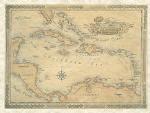
Caribbean. 33 x 25".
Bordered by the United States, Mexico, Central America, and South America, the Caribbean Sea covers almost a million square miles. Its warm waters reach an average depth of 8,448 feet. The lush, windswept islands of the Caribbean are home to more than twenty-five million people. Its larger islands include Cuba, Haiti, the Dominican Republic, Jamaica, and Puerto Rico
$25.00
66-33461
1 sheet, rolled.
$275.00
66-33461D
Deluxe frame
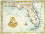
Florida. 33 x 25".
"The Sunshine State" stretches five hundred miles from the Georgia and Alabama borders to Key West, the southernmost point in the United States. Its 65,576 square miles are home to fifteen million people, the fourth largest in population among the states. It boasts the oldest city in America, St. Augustine, as well as the nation's most popular tourist attraction, Disney World. Florida is a haven for retirees, tourists, and the site of the Everglades National Park. Miami is the largest city and the capital is Tallahassee.
$25.00
62-6147
1 sheet, rolled.
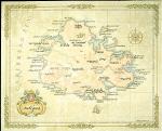
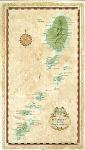
St. Vincent. 18 x 30".
Located in the eastern Caribbean as part of the Windward chain of islands, St. Vincent and the Grenadines have an area of 150 square miles and a population of 118,000. Columbus landed on St. Vincent in 1492 and the island was ruled by Spain, France, and Britain before achieving its independence in 1979. Its economy is based on agriculture and tourism. The capital is Kingstown.
$25.00
66-33959
1 sheet, rolled.
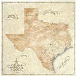
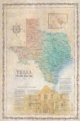
Texas. 23 x 23".
With an area of 268,000 square miles and a population of more than 19 million, Texas is the second largest state in both size and population. Stretching 800 miles from Louisiana to New Mexico, Texas was ruled by Spain and Mexico before becoming an independent nation in 1836. It joined the Union in 1845. Texas boasts a divers economy that includes oil, manufacturing, high tech and agriculture. Its largest cities are Houston and Dallas with the state capital being Austin.
$30.00
62-9546
1 sheet, rolled.
Texas Ltd. Edition Antique-style wall map. 20 x 27". With an area of 268,000 square miles and a population of more than 19 million, Texas is the second largest state in both size and population. Stretching 800 miles from Louisiana to New Mexico, Texas was ruled by Spain and Mexico before becoming an independent nation in 1836. It joined the Union in 1845. Texas boasts a divers economy that includes oil, manufacturing, high tech and agriculture. Its largest cities are Houston and Dallas with the state capital being Austin.
Thumbnail image of the Texas wall map
$40.00
62-95461
1 sheet, flat.
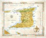
Trinidad. 24 x 18".
Trinidad is the largest and most populous of an archipelagic republic in the southern Caribbean which consists of 23 distinct islands. Today's Trinidad is a diverse island of many different cultures and beautiful natural features that include a variety of beaches, seasonal tropical forests, and the hills of the Northern Range.
$25.00
66-01472
1 sheet, rolled.
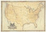
United States. 31 x 23".
With an area of 3,536,278 square miles and a population of more than 265 million, the United States stretches from the Florida Keys in the Atlantic to the Arctic Circle of Alaska and the volcanoes of Hawaii in the Pacific. A former colony of Great Britain, the United States declared its independence in 1776. Composed of fifty states, its federal government is centered in Washington, D.C. A beacon for freedom and economic opportunity, the United States has attracted immigrants from around the globe. It leads the world in manufacturing, medical research, information technology and agricultural production
$25.00
62-2046
1 sheet, rolled.
World Map. 31 x 20-3/4".
The World is made up of seven continents: Asia, Africa, North America, South America, Europe, Australia and Antarctica. Its altitude ranges from Mount Everest at 29,028 feet to Death Valley, California at minus 282 feet. The oceans and seas of the world cover six times the area of its land mass. The world contains more than 160 countries with a population of at least 6 billion. China and India are the most populous countries.


 Thumbnail image of the Texas wall map