This is a series of 19 maps for France that cover a wide variety of tourist subjects, although many are going/have gone out of print. These are ideal for a traveler to use in selecting a route for a theme-based trip. These maps are an essential part of any library's basic France map collection. All are in French only.
$13.99
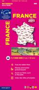
64-5664-901
France Route Map #901.
$13.99
64-5664-906
France Bicycling Map #906.
$13.99
64-5664-908
France Historic Battlefields Map #908.
$13.99
64-5664-909
France Sites Naturels d'Escalades #909.
$13.99
64-5664-911
France Abbeys and Monasteries Map #911.
$13.99
64-5664-914
France Attractions Map #914.
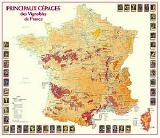
$14.99
64-5664-915
France Wine Map #915.
$13.99
64-5664-916
France Fishing Map #916. Now out of print and only one copy left in stock.
$13.99
64-5664-917
France Garden Map #917.
$13.99
64-5664-919
France Hang-gliding & Parasailing Map #919. Now out of print and only one copy left in stock.
$13.99
64-5664-920
France Flowered Towns & Villages (Villes et Villages Fleuris). #920.
$13.99
64-5664-922
Way of St. James in France (Les Chemins vers Saint-Jacques de Compostelle). #922. The map shows various routes across France taken by pilgrims on their way to Santiago de Compostela in north-west Spain, home to the tomb of the apostle St James - the greatest of all goals for thousands of pilgrims from Europe in the Middle Ages. The routes are clearly marked, with symbols and colours denoting the main routes and various alternatives, cultural monuments and landscapes which appear on the World Heritage list, etc. Towns that have a link to the Compostella theme are also marked, as are places mentioned by Aymeri Picaud in the twelfth century. Text is in easy-to-follow French, while the legend has an English translation. Size is 40 x 52".
Recommended! France Relief Map (Relief de la France). A very handsome image poster highlighting the varied relief of France, from the French Alps to the Brittany coast, all on a black background. The most attractive map of France that we can supply. Size is 60 x 80 cm.
$17.95
64-5687
1 sheet, rolled.
France Physical Map (France Physique). IGN. An attractive wall map of France highlighting the physical features of France. This map has more physical features and less road/cultural information than the map below. Size is 80 x 76 cm, in French.
$16.95
64-56461
1 sheet, rolled.
France General Map (Carte Générale de la France). IGN. An attractive wall map of France showing physical features, roads, etc. Size is 127 x 103cm, in French.
$29.99
64-56462
1 sheet, rolled.
France Topographic Quandrangle Maps
France Topographic Quadrangle Maps. IGN. We can supply all topographic maps of France. Each scale offers complete coverage of France.
The Series Bleue/TOP Series (1:25,000 series Series Blue) is ideal for hiking or genealogy.
The Series Verte (1:100,000 Series Green) is the more general topographic series for France and makes good cycling maps or driving maps.
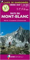
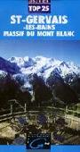
Western Mt. Blanc Topographic Map (Massif du Mont Blanc - St. Gervais). 1:25,000. IGN.
This double-size map illustrates the spectacular topography of this famous mountain. The map is centered on Mont Blanc and covers the main part of the massif from Aiguille du Moine to Col du Petit St-Bernard, and shows the southern section of the Tour du Mont Blanc (TMB) between Chamonix and Courmayeaur in Italy. The map is overprinted with a UTM grid for GPS.
Maps 3531ET and 3630OT combined cover the whole of the TMB, including the sections in Italy and Switzerland, apart from approximately 3 km just north of Courmayeur. In French.
Available as either a paper or waterproof folded map.
$19.99
64-5648-3531ET
Paper map, folded
$29.99
64-5648-3531ETR
Wterproof map, folded
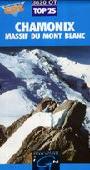
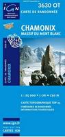
Eastern Mont Blanc Massif - Chamonix. 1:25,000. IGN.
The map covers the northern section of the massif, extending south to the main peak of Mont Blanc, and shows the northern half of the Tour du Mont Blanc (TMB) from Chamonix, across Switzerland, to Val Ferret in Italy. The map is overprinted with a UTM grid for GPS.
Maps 3630OT and 3531ET combined cover the whole of the TMB, including the sections in Italy and Switzerland, apart from approximately 3 km just north of Courmayeur. In French.
Available as either a paper or waterproof folded map.
$19.99
64-5648-3630OT
Paper map, folded
$29.99
64-5648-3630OTR
Waterproof map, folded
Mont Blanc benchmark paperweight. Geo-Situ. Whether you're a climber, hiker, geography buff, or armchair traveler, you'll love to collect or give these unique bench mark paperweights that celebrate the spirit of exploration, athletic challenge, and personal achievement. Cast in pewter these summit marker paperweights are the same diameter as and in the style of official USGS benchmark markers. Please click the "sample" button below to see an enlargement of the paperweight. Each marker has a soft felt pad on the bottom so these can be used on glass, wood, or any surface. Supplied in a soft fleece drawstring pouch, 3¼" diameter.
Larger image of the Mont Blanc paperweight.


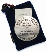
 Larger image of the Mont Blanc paperweight.