Norway Cycling Guides/Maps. Castor Forlag, 2007.
Each guide has separate plastic cycling route maps at 1:100,000 and detailed city maps at 1:20,000.
Descriptive text on the reverse of each map; four map sets are translated into English, three are not (see listings below).
Each guide has a 48-56 pages booklet containing comprehensive information about overnight accomodation, sights worth seeing, swimming places, transport, festivals etc.
5 guides are trilingual English, Norwegian, and German and two are Norwegian only (see each listing below).
A large general map of Southern Norway
A practical plastic storage box for each set.
Sample #1 of a route map Sample #2 of a route map Sample of the descriptive text on the route maps An index map showing the various routes.
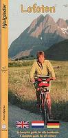
Lofoten. Castor Forlag. This guide includes 16 maps printed on plastic - they stand up to all kinds of weather. Approximately 300 km of cycling route is described, along with
165 places to stay, almost 100 sights to see, places to picnic and swim, service stations and convenience goods shops, and internet addresses, festivals etc.
$44.99
65-1177-04
Set
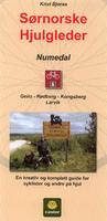
Numedal. Castor Forlag, 2006. Here we present an exciting 271-km route along the mediaeval Numedal Valley. The trip goes from Geilo to Larvik across Mt. Dagali and via Kongsberg. Includes 9 route maps and 2 city maps. Maps and guide are in Norwegian only. Detailed index showing the route.
$44.99
65-1177-06
Set
Setesdal to Hardangar (Setesdal og Hardangar). 1:100,000. Castor Forlag, 2007. This guide covers the 435-km route through the Setesdal Valley and over Mt. Haukeli to Røldal. The route continues to Hardanger and Voss. Includes separate English translations of all of the text on the maps. Includes 14 plastic route maps and 2 city maps.
Detailed index showing the route.
$44.95
65-1177-22
Set
Telemark Canal region (Telemarkskanalen). 1:100,000. Castor Forlag, 2006. Take a 342-km trip along the Telemark Canal and into the interior of Telemark. The trip continues to the Setesdal Valley and across the mountains to Lyse Fjord. Includes 12 plastic route maps and 4 city maps. Maps and guide are in Norwegian only. Detailed index showing the route.
$44.99
65-1177-03
Set
Telemark og Ryfylke. 1:100,000. Castor Forlag, 2006. On this 497-km trip we take you from Lunde to Rjukan via Bø, and then onwards across Mt. Haukeli to Røldal before continuing through Ryfylke to Sauda and Oanes. Includes 16 plastic route maps and 1 city map. Maps and guide are in Norwegian only. Detailed index showing the route.
 Sample #1 of a route map
 Sample #2 of a route map
 Sample of the descriptive text on the route maps
 An index map showing the various routes.
 Detailed index showing the route.
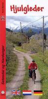
 Detailed index showing the route.
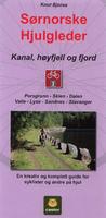
 Detailed index showing the route.
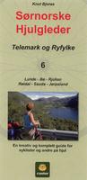 Telemark og Ryfylke. 1:100,000. Castor Forlag, 2006. On this 497-km trip we take you from Lunde to Rjukan via Bø, and then onwards across Mt. Haukeli to Røldal before continuing through Ryfylke to Sauda and Oanes. Includes 16 plastic route maps and 1 city map. Maps and guide are in Norwegian only.
 Detailed index showing the route.