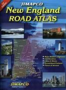
New England Road Atlas. Jimapco. This spiral bound road atlas of New England covers Maine, New Hampshire, Vermont, Massachusetts, Connecticut, and Rhode Island. Includes major roads and highways, communities, lake & rivers, recreational features, and places of interest. 2011, second edition. Spiral-bound, ISBN 9781569146323.
$29.95
62-20959
Atlas.
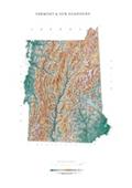
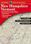
Vermont and new Hampshire Atlas and Gazetteer. 1:110,000. DeLorme. Excellent road atlas with topographic maps and full index. Softcover. More of a recreation atlas with more topographic information than either ofthe Jimapco atlases above/below.
$29.95
62-8148
Atlas
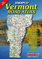
Vermont Road Atlas. Jimapco. 1:108,000 (general maps), 1:27,000 & 1:54,000 (city maps). Spiral-bound road and street atlas. More of a road atlas, and easier to read the roads, than the DeLorme atlas above.
$26.95
62-9788
Atlas.
Vermont Road and City Maps - Paper
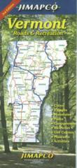
Vermont Road Map. Jimapco. This Vermont Map shows major routes, cities, villages, mountains, parks, campgrounds, ski areas, golf courses, museums, & activities. Shaded relief. This is the perfect tool for autumn fall faliage trips, ski weekends, a summer vacation in the mountains, or just security as you travel the Green Mountain State. 3rd edition, 25.5"x38".
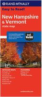
Vermont/New Hampshire Road Map. Rand McNally. Rand McNally's Easy To Read State Folded Map is a must-have for anyone traveling in and around New Hampshire and Vermont, offering unbeatable accuracy and reliability at a great price. Our trusted cartography shows all Interstate, U.S., state, and county highways, along with clearly indicated parks, points of interest, airports, county boundaries, and streets.
The easy-to-use legend and detailed index make for quick and easy location of destinations. Detailed maps of: Burlington, VT; Concord, NH; Manchester, NH; Montpelier/Barre, VT; Nashua, NH; Portsmouth, NH; Rochester, NH. Size is 28 x 40" unfolded.
Bennington & Rutland Counties Map. Includes several inset maps of towns in the region. 1:144,000. (Jimapco).
$4.50
62-9792WIH
Brattleboro & Windham County street map. (Jimapco).
$6.95
62-9792BU
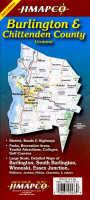
Burlington & Chittenden County Map. Includes coverage of Burlington, South Burlington, Winooski, Essex Junction, Williston, Jericho, Milton, Charlotte and others. 1:36,000 & 1:108,000. (Jimapco).
$4.50
62-9792MON
Montpelier & Barre street map. (Jimapco)
$3.95
62-9792M
Montpelier street map. (Rand McNally)
$4.50
62-9792WIS
Windsor County street map. (Jimapco).
Vermont Road and City Maps - Laminated
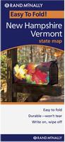
Laminated! Vermont/New Hampshire Easyfinder Road Map - laminated. Rand McNally. The durable and convenient New Hampshire and Vermont Easy-To-Fold state map will take all the wear and tear your journey can dish out. The heavy-duty laminated design allows you to mark your route, make notes, then wipe the surface clean for further use. This is a must-have for navigation whether you're a state resident or just passing through. Size is 18 x 17" unfolded.
Vermont City, County, and State Business Wall Maps
Vermont City Wall Maps.
When it comes to general planning, defining delivery areas, planning direct marketing and delivering products, our city wall maps are perfect to get the detailed information you need.
These maps offer clear mapping by showing all major streets and roads, but leaving out the smaller streets.
If you want a clear map for easy planning, then these are the maps for you; if you want a map showing every little back alley, these are not for you.
We offer state and county wall maps for all of the USA. The maps come in sizes from 24 x 36 to 108 x 144 inches. They are available in variety of mounting and framing options. The maps are ideal for business applications, sales territory, delivery planning, direct mail targeting and hundreds of other applications.
White Mountains Hiking Map. Map Adventures, 2nd edition. Scales vary. This map has separate maps covering the Presidential Range, Crawford Notch, Franconia Notch, Mount Chocorua, and North Conway. The map features full topographic detail, loads of hiking trails, including 50 recommended day hikes, the Appalachian Trail, and mileage between points.
Sample of the White Mountains map detail.
$4.95
62-81730
1 sheet, folded
Burlington, Vermont Hiking and Biking Map. Map Adventures. The Greater Burlington area offers walkers and hikers sandy beaches, rocky lakeside trails, and wildlife. Most walks are short - between one and three miles - for a taste of wilderness, quiet and a brief respite from city life.
Many visitors are surprised to learn that Greater Burlington has some of the best cycling in Vermont. The area has the most developed bike path systems in Northern New England. One side of the map has a map of Burlington and the surrounding villages showing bike and hiking trails. The reverse has text describing trails and points of interest plus a few inset maps.
Image of the front of the map. Image of the reverse of the map.
$4.95
62-97710
1 sheet, folded
Randolph Vermont Mountain Biking Trails, Central Vermont. Map Adventures. The lush White River Valley is two hours or less from Boston, New York, New Hampshire, Connecticut and Burlington, Vermont, offering hundreds of miles of trails within easy reach.
The map includes:
Full topographic information
240 miles of mapped trails
10 suggested bike tours with detailed trail descriptions
Mad River Valley - Long Trail Hikes. 1:50,000. Map Adventures. Take a walk back in time - into the way life used to be and still is, in Vermont.
This map features:
18 guided tours
100 miles of mapped trails
Sections of the Catamount Trail and the Long Trail that run through the Valley
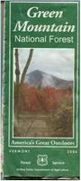
U.S. Forest Service. We stock all available USFS maps for Vermont.
Vermont Raised Relief Maps Hubbard makes an excellent 3D vinyl raised relief map of Vermont/New Hampshire as well as four more detailed raised relief maps of sections of Vermont and New Hampshire. Click on the links below to see sample images and to order.
Vermont State and County Wall Maps. Intelligent Direct.
We offer state and county wall maps for all of the USA. The maps come in sizes from 24 x 36 to 108 x 144 inches. They are available in variety of mounting and framing options. The maps are ideal for business applications, sales territory, delivery planning, direct mail targeting and hundreds of other applications.
Click here to order county wall maps and to see sample images, descriptions, and prices.
Click here to order state wall maps and to see sample images, descriptions, and prices.
Vermont & New Hampshire Shaded Relief Wall Map. 1:500,000. Raven Maps. Our map of central New England combines two states of historic and geographic importance. Elevations are represented by color, and this, in combination with our relief shading technique, gives the map a 3-dimensional look. Size is 66 x 91 cm (26 x 37").
Thumbnail of the map. Sample of the detail.
$40.00
62-8151
Each, rolled
$65.00
62-8151L
Laminated
Vermont Earthquake Maps
Vermont Seismicity Map. 1:1,000,000. 1980. USGS (MF-1262). Map size is 58 x 79 cm.


 Sample detail of the Brattleboro street map
 Sample detail of the Burlington street map
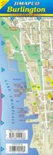 Laminated!
 Sample detail of the laminated Burlington street map
 Sample detail of the laminated Burlington street map
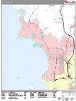
 Sample detail from the Burlington wall map.
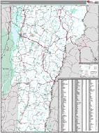 Vermont County and State Wall Maps.
 Sample of the detail.
 Front of the map.
 Back of the map.
 Part of the Legend
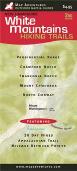
 Sample of the White Mountains map detail.
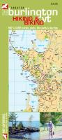
 Image of the front of the map.
 Image of the reverse of the map.
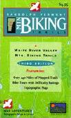
 Front view of the map.
 Sample detail of the map.
 Legend of the map.
 Front view of the map.
 View of the reverse of the map.
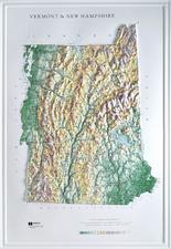
 Thumbnail of the map.
 Sample of the detail.
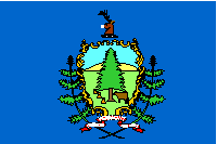 Vermont Flags