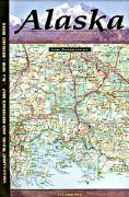
Alaska Road Atlas & Gazetteer. DeLorme. An excellent topographic road atlas with tourist information and gazetteer.
$29.95
62-5348
Alaska Road Atlas & Gazetteer.
Alaska Highway Road Atlas. 1:1,000,000 - 1:1,500,000. ITMB. The famous Alaska Highway of WW2 fame has been largely paved and straightened by now, but is still one of the paramount exploration adventures in the world and is far more accessible than the Karakoram or mid-Australia routes. The original highway, from Dawson Creek in northern British Columbia to close to Fairbanks, Alaska, has been supplemented by several off-shoots: the Dempster Highway leading to Inuvik, in Canada's Northwest Territories, the Dalton Highway, leading north to the high Arctic at Prudhoe Bay in Alaska, and the Stewart Highway leading south through the Coastal Mountains to Prince Rupert, BC are all closely integrated with the traditional Alaska Highway. All of these are shown in great detail in this atlas. Road conditions, distances, campgrounds, convenient hiking trails, heights of land, parks, and everything else that we could think of to make this booklet useful has been included. It has also been very attractively priced, which I hope is being noted. Center-stapled soft-cover atlas.
Sample detail of the Alaska Highway road atlas
$11.95
62-5389
Atlas.
Alaska Road Maps.
Alaska Road Map. 1:3,000,000. Imus Geographics. No other map of Alaska combines the illustrative qualities of detailed terrain shading with abundant information on the same sheet. Approximately 3,500 features identified. Size is 50 x 28 inches, folded. Note that the flat and laminated maps are printed on heavier poster-weight paper.
Alaska map sample Image of the entire Alaska map
$14.95
62-53905
1 sheet, folded.
$29.95
62-53905R
1 sheet, flat.
$39.95
62-53905L
1 sheet, laminated.
Great for classrooms! Alaska Explorer map. 1:3,800,000. Ocean Explorer Publications, 2002. This is an excellent map with far more descriptive photo and text information than other maps.
Sample of the map data. Sample of the text on the reverse.
$12.99
62-53903
1 sheet, folded.
Alaska Road Map. 1:1,500,000. ITMB. America's largest state is a wilderness treasure chest for visitors and the 6th updated edition should meet all their expectations. The map is printed double-sided, with the northern portion on one side and the Aleutian Islands, Kenai Peninsula, and the 'panhandle' on the other. Apart from roads and ferry routes, major attractions, parks and hiking areas are included. The northernmost segment of the Panamericana Adventure Highway is also shown.
Sample detail from the Alaska road map
$10.95
62-53902
1 sheet, folded.
Alaska Road Map. Rand McNally. A standard, very popular, inexpensive road map of Alaska. It has all the roads and otgher basic information, but may lack some of the adventure/recreation information found on the more expensive maps such as the Imus map. Includes detailed maps of Anchorage, Denali National Park, Fairbanks, The Inside Passage, Juneau, Downtown Juneau, Ketchikan, Sitka. Size is 28 " x 40" unfolded.
Sample from the Alaska Road Map
$7.99
62-5390
1 sheet, folded.
Alaska Waterproof Road Maps
Laminated! Alaska Easyfinder Road Map. Rand McNally. A simplified back-pocket laminated road map of Alaska. Ideal for trip planning with a write-on/wipe-off laminated surface. Size is 17 x 18" unfolded, 9" x 4¼" folded.
$9.99
62-53901
1 sheet, folded.
Alaska City Maps
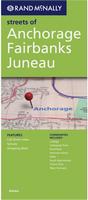
Anchorage City Map - with Fairbanks and Juneau. Rand McNally. Communities include: College, Collegiate Park, Ketchikan, Pennock Island, Sitka, South Bjerremark, Totem Park, and West Fairwest. Map size is 28 x 40 inches unfolded.
Sample from the Anchorage Street Map
$5.99
62-5392A
Anchorage City Map - with Fairbanks and Juneau. (Rand McNally).
Alaska City Wall Maps
Alabama City Wall Maps.
When it comes to general planning, defining delivery areas, planning direct marketing and delivering products, our city wall maps are perfect to get the detailed information you need.
We offer a city wall map for Anchorage.
Click here to see prices, sizes, and mounting options.
U.S. Forest Service. We stock all available USFS maps for Alaska.
Waterproof! New edition.
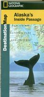
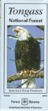
Alaska's Inside Passage Destination Map. Scale 1:880,000. National Geographic Maps.
A perfect map for anyone cruising the Inside Passage. The front side of the Inside Passage map covers from Prince Rupert to north of Skagway, incuding the Tongass National Forest, Juneau, Klondike National Historic Site, Alaska-Chilkat Bald Eagle Preserve, etc. Both sides of the map have extensive text on things to see and do in the area, plus notes on the geology, history, etc. of the region. This is a new, waterproof, revised edition of this map. Size is 26 x 38".
Sample detail of the Inside Passage travel map
$11.99
63-20022
1 sheet, folded
Alaska's Inside Passage Map. 1:900,000. ITMB.
This is a double-sided map, with Vancouver Island and the coastline as far north as Prince Rupert on one side (with inset maps of Seattle, Victoria, and Vancouver)on side 1, and the coastline north to Glacier Bay and an onward inset map to Anchorage (including an inset map of the city) on the second side. As the actual routes followed by the numerous cruise lines vary, we can't show their actual sailing routes, but they generally follow the coastline within viewing distance of either the mainland or coastal islands, or both. We have included the normal ferry routes followed by both BC Ferries and Alaska Ferries in their network of watery trails joining coastal communities, and the large cruise ships follow much the same routes.
Sample detail #1 of the Inside Passage map Sample detail #2 of the Inside Passage map
$10.95
62-5387
1 sheet, folded
Alaska's Inside Passage Maps. 1:633,600. Fine Edge.
The Inside Passage to British Columbia is one of the most sheltered and scenic waterways in the world. Shown are unique scenic and sheltered routes, as well as the more direct express routes, allowing you to customize your own routes, plot your own custom itinerary, and prepare for your trip of a lifetime. Map is folded inside protective cover. The perfect companion for anyone heading north to British Columbia. Map size is 24 x 60".
Northern Portion Map: This map covers northern British Columbia, southeastern Alaska, and the Queen Charlotte Islands portion of the Inside Passage.
Southern Portion Map: This map covers from the Columbia River & Puget Sound to Grenville Channel, British Columbia.
Sample detail of the Northern Inside Passage map Sample detail #2 of the Southern Inside Passage map
Chilkoot Trail & Klondike Gold Rush National Park map. #254. 1:63,360 & 1:86,000.
$14.95
63-2100-274
Chugach State Park map. #274. 1:75,000.
$14.95
63-2100-222
Denali (Mt. McKinley) N.P. 1:333,000.
$11.95
63-2100-257
Gates of the Arctic. #257. 1:400,000.
$14.95
63-2100-255
Glacier Bay N.P. #255. 1:250,000 & 1:94,000.
$14.95
63-2100-763
Kachemak Bay State Park. #763. 1:105,600.
$14.95
63-2100-248
Katmai N.P. #248. 1:125,000.
$14.95
63-2100-231
Kenai Fiords N.P. 1:105,600. (TI #231).
$14.95
63-2100-760
Kenai N.W. Refuge. 1:105,600. (TI #760).
$14.95
63-2100-761
Prince William Sound, West. 1:105,600.
Alaska's Playground - Kenai Peninsula Road and Recreation Map. Great Pacific Recreation Maps. Kenai Fjords National Park • Chugach National Forest • Kachemak Bay State Park • Kenai National Wildlife Refuge
Parks & Recreation Areas
Scenic Viewpoints & Wildlife Watching
Captain Cook SRA
Fishing & Boat Ramps/ Launches
Kachemak Bay
Hiking, Canoe & Snowmobile Trails
Museums & Historic Places
Kids' Activities
$6.95
62-5383
1 sheet, folded.
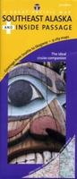
Alaska Southeast and the Inside Passage Travel Map. Great Pacific Recreation Maps.
Comprehensive coverage of Inside Passage from Prince Rupert BC to Yakutat, AK
Detailed city insets of Juneau, Ketchikan, Sitka, Wrangell, Skagway, Petersburg, Haines, Craig & Prince Rupert, B.C. Canada.
Alaska Highway Road Atlas. ITMB. The famous Alaska Highway of WW2 fame has been largely paved and straightened by now, but is still one of the paramount exploration adventures in the world and is far more accessible than the Karakoram or mid-Australia routes. The original highway, from Dawson Creek in northern British Columbia to close to Fairbanks, Alaska, has been supplemented by several off-shoots: the Dempster Highway leading to Inuvik, in Canada's Northwest Territories, the Dalton Highway, leading north to the high Arctic at Prudhoe Bay in Alaska, and the Stewart Highway leading south through the Coastal Mountains to Prince Rupert, BC are all closely integrated with the traditional Alaska Highway. All of these are shown in great detail in this atlas. Road conditions, distances, campgrounds, convenient hiking trails, heights of land, parks, and everything else that we could think of to make this booklet useful has been included. It has also been very attractively priced, which I hope is being noted. Center-stapled soft-cover atlas.
Sample detail of the Alaska Highway road atlas
$11.95
62-5389
Atlas.
U.S. National Park Maps by the USGS. USGS.
$12.95
62-5375G
Glacier Bay N.P. 1:250,000. (USGS).
$19.95
62-5375GL
Glacier Bay N.P. - Laminated.
$12.95
62-5375P
Mt. McKinley N.P. 1:250,000. (USGS).
$24.95
62-5375PL
Mt. McKinley N.P. - Laminated.
Chilcoot Pass, Denali High Point, and Mt. McKinley benchmark paperweights. Geo-Situ. Whether you're a climber, hiker, geography buff, or armchair traveler, you'll love to collect or give these unique bench mark paperweights that celebrate the spirit of exploration, athletic challenge, and personal achievement. Cast in pewter these summit marker paperweights are exact replicas of official USGS benchmark markers. Please click the "sample" button below to see an enlargement of the paperweight. Each marker has a soft felt pad on the bottom so these can be used on glass, wood, or any surface. Supplied in a soft fleece drawstring pouch, 3¼" diameter.
$59.95
62-5397CP
Chilcoot Pass, Klondike Gold Rush National Historical Monument, AK paperweight. 3,487 ft.
$59.95
62-5397DE
Denali Continental High Point, Denali National Park, AK paperweight - historic elevation.
$59.95
62-5397DEN
Denali Continental High Point, Denali National Park, AK paperweight - new elevation.
$59.95
62-5397MC
Mt. McKinley, Denali National Park paperweight - historic elevation. This is different than the continental high point Denali paperweights listed above.
$59.95
62-5397MCN
Mt. McKinley, Denali National Park paperweight - new elevation. This is different than the continental high point Denali paperweights listed above.
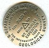
Mt. McKinley benchmark lapel pin. Geo-Situ. These lapel pins, measuring approximately 7/8" across, replicate official USGS benchmarks located on the tops of major mountains in the US. These pins, made of high quality pewter, offer a unique reminder of one's climb towards the summit. Each pin comes with a brief description of the location, including such information as how the mountain got its name.
$11.95
62-5397MCL
Alaska Wall Maps
Alaska State and County Wall Maps. Intelligent Direct.
We offer state and county wall maps for all of the USA. The maps come in sizes from 24 x 36 to 108 x 144 inches. They are available in variety of mounting and framing options. The maps are ideal for business applications, sales territory, delivery planning, direct mail targeting and hundreds of other applications.
Click here to order county wall maps and to see sample images, descriptions, and prices.
Click here to order state wall maps and to see sample images, descriptions, and prices.
Alaska Wall Map. 1:3,000,000. Imus Geographics. No other map of Alaska combines the illustrative qualities of detailed terrain shading with abundant information on the same sheet. Approximately 3,500 features identified. Size is 50 x 28 inches. Note that the flat and laminated maps are printed on heavier poster-weight paper.
NOTE: This map is also listed under the folded travel maps above.
Image of the entire Alaska map Alaska map sample #1 Alaska map sample #2 Alaska map sample #3
$29.95
62-53905R
1 sheet, flat.
$39.95
62-53905L
1 sheet, laminated.
$14.95
62-53905
1 sheet, folded.
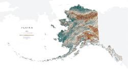
Alaska Wall Map. National Geographic Maps. This map offers a dramatic visualization of Alaskas physical geography. Land cover colorization distinguishes forests and deserts. Stunning shaded relief depicts mountains and ocean depths. The map locates and names cities, towns, islands airports, national and state parks, military bases, mountains (with peak elevations), lakes, rivers, and other natural features. Size is 41 x 30 inches.
Sample detail of the Alaska wall map. Thumbnail of the Alaska wall map.
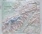
Alaska Physical Relief. 1:4,800,000. DeLorme Mapping. 15.5" x 21". This small format map is an excellent reference tool. Besides physical relief, it depicts roads and towns and a grid showing latitude and longitude. This is the same map that appears in the front section of DeLorme's Alaska Topographic Atlas and Gazetteer.
$2.99
62-5349
Each, rolled
Alaska Antique-style Wall Map. 30 x 20". Alaska was admitted to the Union as the 49th state. Known as "The Last Frontier" it is the largest state in area, covering 570,374 square miles. Purchased from Russia in 1867 for $7.2 million, at first Alaska was called "Seward's Folly" after the Secretary of State who engineered its acquisition. The "folly" turned into a bargain when gold was discovered in the Klondike in 1896. Site of Mount McKinley, the highest peak in North America, Alaska is famous for its national parks, abundant wildlife and vast expanse of wilderness.


 Sample detail of the Alaska Highway road atlas
 Alaska map sample
 Image of the entire Alaska map
 Great for classrooms!
 Sample of the map data.
 Sample of the text on the reverse.
 Sample detail from the Alaska road map
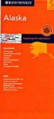
 Sample from the Alaska Road Map
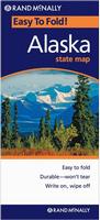 Laminated!
 Sample from the Anchorage Street Map
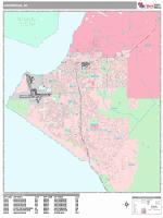

 Sample detail of the Inside Passage travel map
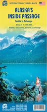
 Sample detail #1 of the Inside Passage map
 Sample detail #2 of the Inside Passage map
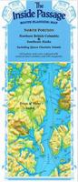
 Sample detail of the Northern Inside Passage map
 Sample detail #2 of the Southern Inside Passage map
 Index of Alaskan map coverages
 Thumbnail of the Denali/Mt. McKinley map
 Sample of the map detail from the Denali map
 Thumbnail of the front of the Klondike Gold Rush map.
 Thumbnail of the reverse of the Klondike Gold Rush map
 Detail from the Klondike Gold Rush map.
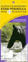
 Alaska Inside Passage map sample
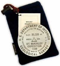


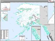 Alaska State and County Wall Maps. Intelligent Direct.
 Alaska map sample #2
 Alaska map sample #3
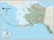
 Sample detail of the Alaska wall map.
 Thumbnail of the Alaska wall map.
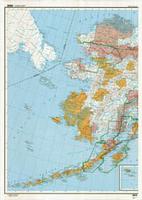
 Thumbnail of the Alaska topographic map.
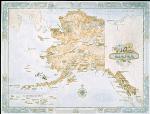

 Alaska Flags