We stock a huge selection of USA Maps, from 6-foot USA wall maps to specialty maps of the states to city street maps. The links below will take you to various types of maps of the USA that we carry.
Would you like recommendations? Just call or e-mail us - our experienced staff can offer recommendations for just about any type of map that you might want.
U.S.A. Maps - our USA Maps home page with links to all of our USA maps.
United States Specialty Folded Maps
Colleges & Universities of the United States. White Star Press.
A great tool for prospective students, counselors, and educational planners! 1400+ top colleges in the US and Canada, identified as public or private, single-sex, and religiously affiliated, with a handy index by name along the bottom.
Available folded or flat/laminated. Size is 39 x 27 inches flat/unfolded.
Sample of the map detail Thumbnail image of the map
$14.99
62-20773
1 sheet, folded.
$39.99
62-20773L
Laminated.
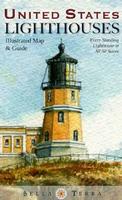
United States Lighthouses Map. Bella Terra. Map size, unfolded/flat, is 39 x 27 inches.
The most up-to-date and comprehensive U.S. lighthouse directory.
All 770 standing lighthouses in the 50 states located on detailed regional maps--including Lake Havasu, AZ/CA.
Each official lighthouse name, alternate names, year of first lighting, year of current structure, physical location & latitude/longitude.
46 original watercolor illustrations, many newly commissioned.
Click here" to see our complete listing of lighthouse maps for regions and some states of the USA!
New edition Baseball Travel Map. Professor Pathfinder (Hedberg).
This handy laminated map is perfect for baseball fans and road-trippers of all ages. Shows every major league team (including spring training), minor league team, and independent league team in the U.S. and Canada.
The index includes contact information, along with the most complete listing of baseball attractions anywhere!
Sample detail from the Baseball map.
$8.99
62-20772
1 sheet, folded.
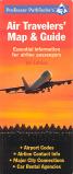
A must for all business travelers! Professor Pathfinder's Air Travelers' Map & Guide. Hedberg Maps.

 Sample of the map detail
 Thumbnail image of the map
 Sample detail of the USA Lighthouses Map
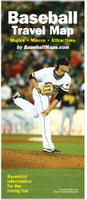 New edition
 Sample detail from the Baseball map.