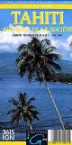
Tahiti Travel Map. 1:100,000. ITMB. This map covers Tahiti and the nearby Society islands of Bora Bora, Moorea, Tahaa, and Raiatea. A detailed inset of Papeete, the capital, is also included. Tahiti forms part of the French overseas possessions and, as such, is part of the European Community. The island of Tahiti Nui is the most developed of the islands, and the map shows numerous dive sites and beaches. Most of the resorts are located close to Papeete and the airport, but each of the islands has resort accommodation shown. Bora Bora seems to be well-endowed with resorts. Again, this map is considerably less expensive than the 'other' map on the market, and is much more oriented to the needs of travellers.
Sample detail of the Tahiti travel map
66-12732
1 sheet, folded.
$12.95
Tahiti & The Society Islands Physical/Travel Map (Archipel de la Société; Tahiti). 1:100,000. IGN (3615). Illustrates the major islands such as Tahiti, Bora Bora, Moorea, Tahaa, and Raiatea. Elevation is shown by shaded relief. Tourist information on golf courses, hotels, car rentals, and more is also shown. In French; 120 x 89 cm.
Sample #1 Sample #2
66-12733
1 sheet, folded
$18.99
Society Islands fish cards and dive maps. Franko's Maps. These dive maps and fish cards have a map of the island showing popular dive spots on one side and on the reverse a chart of the common sea creatures for that area. Laminated, with holes for a dive binder or a lanyard.
66-12734-BOR
Bora Bora fish card & dive map.
$5.99
66-12734-MOO
Moorea fish card & dive map.
$5.99
66-12734-SOC
Society Islands Fish Card.
$5.99
66-12734-TAH
Tahiti fish card & dive map.
$5.99
Tahiti Satellite Poster. This satellite image of Tahiti (French Polynesia) is beautifully color balanced along with some high detail. Additionally, this satellite map makes a great companion with our Pacific Island satellite posters and maps.
Image of entire poster Sample of the map detail
66-12706
1 sheet, flat.
$29.95
Tahiti Geologic Map. 1:25,000. Ministère de la Mer, de l'Equipement et de l'Energie, Papeete. The three sheets below cover the north, western, and southwestern regions of Tahiti; additional sheets will hopefully be printed in the future.
Each map includes:

 Sample detail of the Tahiti travel map
 Sample #1
 Sample #2
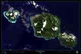
 Image of entire poster
 Sample of the map detail
 Tahiti Flags