Solomon Islands Maps


Solomon Islands Travel Map. 1:900,000. ITMB. The only available travel map for the Solomon Islands.
Ordering Solomon Islands travel map (ITMB)66-127661 sheet, folded$10.95


Solomon Islands Topographic Quadrangle Maps. 1:150,000. Ministry of Agriculture and Lands. 1973-1976.
Ordering Sol. Is., Ontong--topo.  1:25066-12744POntong. 1 sheet.$15.95


Solomon Islands Topographic Quadrangle Maps. 1:50,000. 1967-1976. DOS (456). This series covers all of the islands in the island group. Indexes are shown below for the main islands; please contact us for information on the smaller islands in the group.


Solomon Islands 1:50,000 Topographic Map Series

Published byDOS.
Scale1:50,000
Publication dates1967-1976.
ProjectionTransverse Mercator.
Contour interval.
Number of sheets90 maps.
Index map Choiseul index map - click here.
Guadalcanal index map - click here.
Malaita index map - click here.
New Georgia index map - click here.
San Cristobel index map - click here.
Santa Isabel index map - click here.
Map sample
Map qualityGood quality full-color topographic maps.
LanguageEnglish.
        66-12745Each sheet$18.95
Listing of QuadranglesClick here to order individual sheets and island sets.


Choiseul Geologic Map. 1:200,000. 1982. SIGD.
Ordering Choiseul--Geologic Map.  1:20066-1275CH1 sheet, folded$14.95


New Georgia Group Geologic Map. 1:250,000. 1988. SIGD.
Ordering New Georgia--Geologic Map 1:2566-1275NG1 sheet, folded$14.95


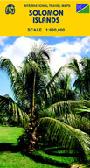
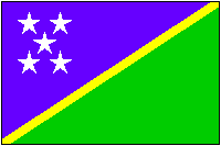
Solomon Islands Flags
Ordering Flag-Solomon Islands67-1070SOLSolomon Islands flag, small. Size 4 x 6 in.$3.99
Ordering Solomon Islands flag.  2 x 367-1073SOLSolomon Islands flag, large. Size 2 x 3 ft.$64.95


image


© Copyright 2025 East View Companies, Inc.
5130 Industrial Street, Suite 100, Maple Plain, MN 55359-8005
All Rights Reserved
For more information please Contact Us