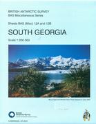
South Georgia Map. 1:200,000. British Antarctic Survey #12A and 12B, 2004. This is a double-sided map with a topographic map on one side and a satellite image map on the reverse. The topographic map is derived from earlier DOS mapping and updated with more recent Landsat imagery. The map has contour lines and spot heights and depth shading for the near-shore ocean regions. The map shows Shackleton's route, whaling and research stations, and more. The map on the reverse is based on Landsat imagery. The map lacks contour lines and elevation information, which makes it easier to see the satellite data - more appropriate for a wall map.
Sketch map showing map coverage
$24.99
66-10786
1 sheet, folded
South Georgia Topographic Map. 1:200,000. DOS (610). 1979. Color version of the official topographic map. Old but contains more names than the South Georgia map above.
 Sketch map showing map coverage
