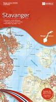
All of Norway is covered by detailed topographical maps at 1:50.000 scale. The Norway Series is a complete set of English-language topographic maps. The series has 195 maps. Each map covers an area of 45x62 kilometers with a 2-km overlap between the sheets. The coordinate system is EUREF89 (WGS 84) which would makes it easy to use with a GPS receiver. The maps are printed on water-resistant and tear-resistant synthetic paper.
 All of Norway is covered by detailed topographical maps at 1:50.000 scale. The Norway Series is a complete set of English-language topographic maps. The series has 195 maps. Each map covers an area of 45x62 kilometers with a 2-km overlap between the sheets. The coordinate system is EUREF89 (WGS 84) which would makes it easy to use with a GPS receiver. The maps are printed on water-resistant and tear-resistant synthetic paper.
 Index map.
 Index map.