Kermadec Islands


  • Worldwide Nautical Charts
  • Map Pins, Map Tacks, Map Flags. Great marker pins, pennants, and flags for marking locations on maps. Multiple colors, numbered also.
  • Gifts for the Map Enthusiast.
  • Travel aids and accessories.


    Raoul Island travel map
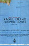
    (Kermadec Islands) Raoul Island Topographic Map. 1:25,000. 1982. NZLS. Contour interval is 20 metres. The map shows tracks suitable for vehicles and footpaths, and includes a diagram of the meteorological station based on the island. With a UTM grid and margin ticks for latitude and longitude in steps of 1'.
    Ordering Kermadec Is., Raoul--Topo66-1245TEach, folded$9.95


    image


  • © Copyright 2025 East View Companies, Inc.
    5130 Industrial Street, Suite 100, Maple Plain, MN 55359-8005
    All Rights Reserved
    For more information please Contact Us