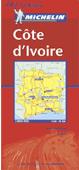
Ivory Coast Travel Map. 1:800,000. Michelin. A map with an extensive road network - the width, type of surface and whether passable in wet weather. Gas stations are also shown. The background to the map shows forested areas, spot heights and nature reserves. An inset map of the Abidjan area and a climate table are included.
$12.95
64-8390
1 sheet, folded
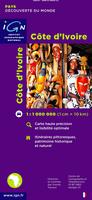
Ivory Coast Travel Map (Cote d'Ivoire). 1:1,000,000. IGN, France. This road map shows all type of roads, some tourist information, and elevation through relief shading. In French.
$16.99
64-83901
1 sheet, folded
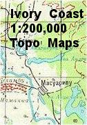
Ivory Coast 1:200,000 Topographic Quadrangle Map Set. 1:200,000. Soviet government.
High quality topographic maps for a country where little else is available. This set of 60 sheets gives complete coverage of Ivory Coast. In Russian. Available as color plots or non-georeferenced raster files.
Please specify area of interest in the "comments" section when you check out.
$19.99
64-8351
Color plot.
$720.00
64-83515D
Set of 60 sheets, as non-georeferenced raster files
 Ivory Coast Maps