There are some excellent geological atlases covering the Indian Ocean.
For coverage of some of the individual islands, please see the listings indicated in the chart below.
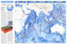
Indian Ocean Floor Map. National Geographic Maps Classic Collection. 1992. This attractive physical map of the Indian Ocean floor appeared in the June 1992 issue of National Geographic. It contains an article entitled "Changing the Face of Earth" and additional information on continental drift. The map showss detail of such submarine terrain as fracture zones, basins, and ridges is stunning. A wonderful companion to the ocean floor map of the Pacific Ocean which appeared in the same issue.
Thumbnail image of the entire map Sample of the map detail.
66-11150
flat
$29.95
66-11150L
Laminated
$39.95
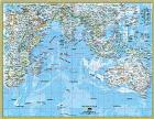
Indian Ocean Political Map. National Geographic Atlas Collection. This informative map shows ocean depths and currents, trade winds and other wind patterns, major sea locations, as well as surrounding countries and continents.
Map of the Indian Ocean. 1:20,000,000. CGMW, 2004. Two sheets - sbeet one shows the physiography of the Indian Ocean. Sheet two is a structural map of the region. Each sheet is 118 x 77 cm in size.
Sample of the physiography sheet Sample of the structure sheet Physiography map. This map with its computer-generated image of the emerged and submarine morphology includes isobaths at -200m, -1000m, and then every 1000m. The map also shows the approximately 300 active or Holocene volcanoes and approximately 40 impact craters.
Structural map. This map represents onshore simplified geologic featuers: basins, orogenies, major faults, etc. Offshore the accent is on the structuration of the oceanic crust: chronostratigraphic ages, spreading axes, transform faults, subduction zones, and anomalous reliefs such as aseismic ridges and oceanic plateaus. Earthquakes of 5.0 magnitude or greater are plotted both onshore and offshore.
66-1101
Two sheets + text.
$29.95
(Indian Ocean) World Ocean Atlas Series, Atlantic & Indian Oceans. 1977. USSR. Excellent oversized atlas with 306 pages of maps illustrating currents, temperature, explorers' routes, and much more. In Russian. This is the same atlas as listed in the Atlantic Ocean section.
66-1004
Atlas
$225.00
(Indian Ocean) Geological and Geophysical Atlas. 1991. IOC (Moscow). The atlas includes numerous maps; developments of ocean research technology; research data; and bibliography. In English; 151 pages. Our stock is limited.
66-1105
Geological Atlas
$195.00
Indian Ocean Seismicity Map. NOAA. 1970. Shows seismic activity for 1962-1969. A black/white map.
 Thumbnail image of the entire map
 Sample of the map detail.
 Thumbnail image of the entire map
 Sample of the map detail.
 Sample of the physiography sheet
 Sample of the structure sheet