Moon Geologic Atlas. 1:5,000,000. 1978. USGS (I-Series). Shows details of the unusual geology of the Moon in six sheets. With numerous inset maps. Each sheet approx. 130 x 80 cm.
Image of the Moon near-side map
67-7701
Near side, folded
$10.95
67-7702
East side, folded
$9.95
67-7703
West side, folded
$9.95
67-7704
Central far side, folded
$9.95
67-7705
North side, folded
$9.95
67-7706
South side, folded
$9.95
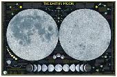
Map of the Moon. Hallwag. Colorful wall map printed on both sides to show front and rear views of the Moon. 84 x 84 cm (33" x 33").
Sample of the map detail
67-7750
1 sheet, folded
$13.95
Spirit on Mars Poster. Spaceshots. This image includes the panoramic taken from Spirit's Camera as well as the Columbia Plaque tribute. This poster comes with a double - sided key loaded with links and educational sites to further enrich children on many different astronomy subjects.
Twelve different images are on the poster, including a 360º panorama image.
67-879601
Paper.
$11.95
67-879601L
Laminated.
$21.95
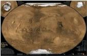
Mars, the Red Planet Reference Map. National Geographic Maps. See Mars as it really looks, from the heights of Olympus Mons (nearly 70,000 feet above the surface), to ancient canyons, to Hellas Planitia, the lowest point on Mars, where a meteorite punched a hole in the surface 1,300 miles wide and five miles deep. Mars Revealed was created for National Geographic with over 1,000 images taken by the Mars Orbiter Camera, and merged with 330 million elevation points to create the sharpest view yet of Mars and its spectacular terrain. Size is 20 x 31", double-sided.
An image of the front side of the map An image of the reverse side of the map A detail from the map
67-7849
Flat/rolled
$19.99
67-7849L
Laminated
$24.99
Mars Geologic Map. USGS (I-1802).
67-7800
Each, folded
$9.95
Mars Shaded Relief Map. 1:25,000,000. 1975. USGS (I-940). This map was compiled from Mariner 9 images. It illustrates the topography of Mars using two polar projections and one equatorial projection. 99 x 103 cm.
67-7850
1 sheet, folded
$9.95
Mars Topographic Map. 1:25,000,000. USGS (I-2179). 1991.
67-7851
1 sheet, folded
$10.95
Mars Regional Shaded Relief Maps. 1:15,000,000. 1982. USGS (I-1320, I-1321, I-1322). These maps are enlargements of 67-7850 above. The surface is seen in greater detail, however these maps lack the geographic names shown on 67-7850. Sheet size is 79 x 79 cm. Folded.
67-7852A
Western region
$9.95
67-7852B
Eastern region
$9.95
67-7852C
Polar regions
$9.95
Mercury Relief and Albedo Maps. 1:15,000,000. 1979. USGS (I-1171). These maps were compiled from images taken by Mariner 10. Due to the flight path, images are available for only one-half of the planet. 64 x 104 cm.
Image of the entire map
67-7450
Each, folded
$9.95
Io Geologic Map. 1:15,000,000. U. S. Geological Survey (I-2209). 1992.
67-7905
1 sheet, folded
$9.95
Pictorial Maps of the Moons of Jupiter. 1:25,000,000. 1979. U.S. Geological Survey (I-1239, I-1240, I-1241, I-1242). These maps were made from images taken by the Voyager I and II spacecraft. Due to the flight paths, some maps are highly distorted (such as Europa), but each map shows some interesting features like the huge fault scarps of Europa. Sheet size varies. Folded.
67-7972
Callisto
$9.95
67-7973
Europa
$9.95
67-7974
Ganymede
$9.95
67-7975
Io
$9.95
Atlas of the Surface of Venus. 1:4,000,000 - 1:10,000,000. GUGK. 1989. The atlas shows physical characteristics of the surface of Venus, including hypsometry, geology, and numerous photos. Hardbound, 328 pages. In Russian.
Map of the Stars. Hallwag. The map shows the Northern Sky and Southern Sky, with major constellations marked, with indications of magnitude and color of the stars. 126 x 83 cm (49.5" x 32.5").
Sample detail of the map
 An image of the full map
 A detail of the map
 An enlarged view of the mounted map
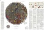
 Image of the Moon near-side map
 Sample of the map detail
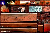

 An image of the front side of the map
 An image of the reverse side of the map
 A detail from the map
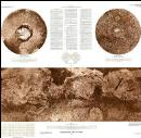
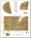
 Image of the entire map
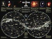
 An image of the full map
 A detail of the map
 A sample of the legend
 Sample detail of the map
 An image of the front of the map
 An image of the reverse of the map
 Sample detail of the map
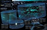
 An image of the full map
 A detail of the map
 A sample of the legend