Congo, D.R. Congo, and Central African Republic Travel Map. 1:2,000,000. ITMB.
It covers all of the Democratic Republic of Congo (the former Congo-Kinshasa, or Zaire), all of the People's Republic of the Congo (known as Congo-Brazzaville or French Congo), and the Central African Republic to the north. This is in reality a map of the vast rain forest known as the Congo River Basin.
A word of warning: the road network in both Congos is primitive - that means largely non-existent or in such poor condition as to wreck army trucks. ITMB shows the roads, and tried to classify them by quality, but this is a 'work in progress' and I hope that this map will create sufficient feedback to improve this aspect of the map.
Sample detail #1 from the Congo Travel Map Sample detail #2 from the Congo Travel Map
$12.95
64-42901
1 sheet, folded
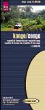
Waterproof! Dem. Rep. Congo & Rep. Congo Travel Map. 1:2,000,000. Reise Know-How.
This map covers both the Dem. Republic of the Congo (formerly Zaire) and the Republic of Congo. It is a detailed road map printed on waterproof and tear-resistant synthetic paper (Polyart). The map shows elevation with contour lines and elevation tinting. In German with multilingual legend.
$15.99
65-57903
Each, folded
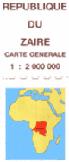
Dem. Rep. Congo General Map. 1:2,000,000. Belgium IGN.
A 2-sheet map which measures 119x132cm when assembled. This was published in 1988 by the Belgium Survey in association with the Institute Geographique du Zaire.
Although it is out of date and is not indexed, it is noteworthy for its clarity (no relief shading) and somewhat greater level of detail compared to other existing products, eg. inclusion of more smaller settlements, more extensive breakdown of divisions, electricity power lines, etc.
Latitude and longitude lines are at 1° intervals. The area beyond the country's border is left blank. Includes three inset maps showing the vegetation distribution (forest & savannah), the general relief (altitude tinting) and main administrative divisions.
$35.99
65-5749
1 sheet, folded
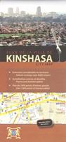
(Congo) Kinshasa City Map (Plan de la ville de Kinshasa). Approx. 1:15,000. Kinart & Media/Aquaterra.
An excellent city street map of Kinshasa showing the locations of embassies, tourist facilities, etc. A comprehensive street index is included. Bilingual French/English.
Sample detail of the Kinshasa map
$24.99
65-5792KI
1 sheet, folded
Lubumbashi Street Map. Aquaterra, Belgium.
The first complete and detailed city map showing "Congo's economic capital". Printed on both sides, the map shows excellent detail for Lubumbashi, which is D.R. Congo's economic capital. The map has over 200 points of interest, street-name index, list of points of interest, and contact information. Map size is 110 x 99 cm.
Sample detail from the Lubumbashi map.
Kalemie (Albertville/Albertstad) city map. 1:12,500. 1980.
$25.00
65-5792LU
Kananga (Luluabourg) city map. 1:12,500. 1962, reprinted 1999.
$25.00
65-5792LI
Likasi (Jadotville/Jadotstad) city map. 1:12,500. 1981.
$25.00
65-5792MA
Matadi city map. 1:12,500. 1962, reprinted 1999. Main seaport for D.R. Congo.
Dem. Rep. Congo (Zaire) 1:200,000 Topographic Quadrangle Map Set. 1:200,000. Soviet government.
High quality topographic maps for a country where little else is available. This set of 86 sheets gives nearly complete coverage of the DRC. In Russian.
$19.99
65-5752
Individual topo quad, specify area. Paper.
D.R. Congo Topographic Maps - TPC/Tactical Pilotage Charts & ONC/Operational Navigation Charts. 1:500,000 & 1:1,000,000. NGA.
Standard topographic maps of Sudan are restricted by the D.R. Congo government. World Aeronautical Charts, including TPC and ONC charts, cover land areas at a standard size and scale for navigation by aircraft operating at high altitudes. However, their level of detail makes them useful as topographic maps for those areas where little else is available. The topographical information includes city tints, principal roads, railroads, distinctive landmarks, drainage patterns, topography and relief. contour lines are at 500 feet intervals, with intermediate contours where appropriate, along with numerous spot heights. Color tints on a hypsometric scale are also shown. The aeronautical information includes visual and radio aids to navigation, airports, airways, restricted areas, obstructions and other pertinent data.
There is less detail in some areas due to insufficient information - these areas are labelled on the charts. These are large maps, with a typical size of 42 x 56 inches. Due to the size and color variation of the different print runs and the Conformal Conic Projection, these maps do not splice together well. World Aeronautical Charts are not recommended for use by pilots of low speed, low altitude aircraft.
NOTE: These maps have been restricted by the US military. We cannot obtain new stock after we sell our current inventory.
Index showing sheet coverage Sample from the TPC series (image is from a sheet covering Korea) Sample from the ONC series (image is from a sheet covering Korea)
$34
67-1055-L04B
TPC Chart L-4B. D.R. Congo/Cent. African Rep./Sudan. East 24°-30°, North 4°-8°.
$34
67-1055-L04C
TPC Chart L-4C. D.R. Congo. East 24°-30°, North 0°-4°.
$34
67-1055-L05A
TPC Chart L-5A. D.R. Congo/Ethiopia/Kenya/Sudan. East 30°-36°, North 4°-8°.
$34
67-1055-M03B
TPC Chart M-3B. Congo/D.R. Congo/Gabon. East 13°-19°, South 0°-4°.
$34
67-1055-M03C
TPC Chart M-3C. Angola/Congo/D.R. Congo. East 13°-19°, South 4°-8°.
$34
67-1055-M03D
TPC Chart M-3D. Angola/Congo/D.R. Congo. East 7°-13°, South 4°-8°.
$34
67-1055-M04B
TPC Chart M-4B. Burundi/D.R. Congo/Rwanda/Tanzania/Uganda. East 25°-31°, South 0°-4°.
$34
67-1055-N04A
TPC Chart N-4A. Angola/D.R. Congo. East 18°-24°, South 8°-12°.
1:1,000,000 ONC Charts.
$34
67-1056-L03
ONC Chart L03. East 8°-16°, North 0°-8°. Only a tiny corner covers D.R. Congo.
$34
67-1056-L04
ONC Chart L04. East 18°-30°, North 0°-8°.
$34
67-1056-L05
ONC Chart L05. East 30°-42°, North 0°-8°.
$34
67-1056-M03
ONC chart M03. East 7°-19°, South 0°-8°.
$34
67-1056-M04
ONC chart M04. East 19°-31°, South 0°-8°.
$34
67-1056-N04
ONC chart N04. East 18°-30°, South 8°-16°.
$34
67-1056-N05
ONC Chart N05. East 30°-42°, South 8°-16°. Only a tiny corner covers D.R. Congo.
 Democratic Republic of the Congo Maps (formerly Zaire)
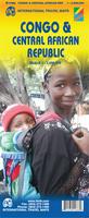
 Sample detail #1 from the Congo Travel Map
 Sample detail #2 from the Congo Travel Map
 Waterproof!


 Sample detail of the Kinshasa map
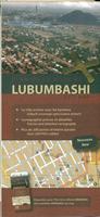
 Sample detail from the Lubumbashi map.
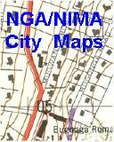
 Sample from the Maputo map from the same series.
 Sample from the Entebbe map from the same series.
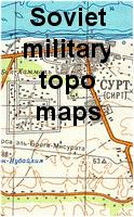

 Index showing sheet coverage
 Sample from the TPC series (image is from a sheet covering Korea)
 Sample from the ONC series (image is from a sheet covering Korea)
 Dem. Republic of the Congo (Zaire) Flags