Congo, D.R. Congo, and Central African Republic Travel Map. 1:2,000,000. ITMB, 2012. It covers all of the Democratic Republic of Congo (the former Congo-Kinshasa, or Zaire), all of the People's Republic of the Congo (known as Congo-Brazzaville or French Congo), and the Central African Republic to the north. This is in reality a map of the vast rain forest known as the Congo River Basin.
A word of warning: the road network in both Congos is primitive - that means largely non-existent or in such poor condition as to wreck army trucks. ITMB shows the roads, and tried to classify them by quality, but this is a 'work in progress' and I hope that this map will create sufficient feedback to improve this aspect of the map.
Sample detail #1 from the Congo Travel Map Sample detail #2 from the Congo Travel Map
64-42901
1 sheet, folded
$12.95
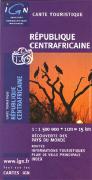
Central African Republic General Map (Carte Générale). 1:1,500,000. IGN, France. This shaded relief map illustrates mileages between cities, airports, roads, hospitals, and tourist points of interest. In French, 120 x 65 cm.
64-3750
1 sheet, folded
$15.99
Central African Republic Topographic Quadrangle Maps (TPC/Tactical Pilotage Charts). 1:500,000. NGA. World Aeronautical Charts, including TPC and ONC charts, cover land areas at a standard size and scale for navigation by aircraft operating at high altitudes. However, their level of detail makes them useful as topographic maps for those areas where little else is available. The topographical information includes city tints, principal roads, railroads, distinctive landmarks, drainage patterns, topography and relief. contour lines are at 500 feet intervals, with intermediate contours where appropriate, along with numerous spot heights. Color tints on a hypsometric scale are also shown. The aeronautical information includes visual and radio aids to navigation, airports, airways, restricted areas, obstructions and other pertinent data. There is less detail in some areas due to insufficient information - these areas are labelled on the charts. These are large maps, with a typical size of 42 x 56 inches. Due to the size and color variation of the different print runs and the Conformal Conic Projection, these maps do not splice together well. World Aeronautical Charts are not recommended for use by pilots of low speed, low altitude aircraft.
Index showing sheet coverage Sample from this series (image is from a sheet covering Korea)
TPC 1:500,000 Charts
67-1055-K03C
TPC Chart K03C. Cameroon/Chad/Nigeria. North 8°-12°, East 13°-19°. Print-on-demand color plot.
$34
67-1055-K04D
TPC Chart K04D. Central African Republic/D.R. Congo/Sudan. North 8°-12°, East 19°-25°. Print-on-demand color plot.
$34
67-1055-L03B
TPC Chart L03B. Cameroon/Central African Republic/Chad/Nigeria. North 4°-8°, East 12°-18°.
$34
67-1055-L04B
TPC Chart L04B. D.R. Congo/Cent. African Rep./Sudan. North 4°-8°, East 24°-30°. Print-on-demand color plot.
$34
ONC 1:1,000,000 Charts
67-1056-L03
ONC Chart L03. Africa. North 0°-8°, East 8°-16°.
$34
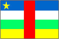
Central African Republic Flags
67-1070CAR
Central African Republic flags, small. Size 8 x 12 in.
$3.99
67-1073CAR
Central African Republic flags, large. Size 2 x 3 ft.
 Central African Republic Maps
 Sample detail #1 from the Congo Travel Map
 Sample detail #2 from the Congo Travel Map


 Index showing sheet coverage
 Sample from this series (image is from a sheet covering Korea)
 Central African Republic Flags