The map shows all the island's known roads and streets with their names, displays its many diving sites and an extensive set of biking routes, and locates all the major hotels by name.
The map contains the following features:
Rich topographic detail
Symbol key and scale; depth curves, soundings, heights, and contour lines in meters, longitude and latitude lines and other identifiers.
Indian inscriptions (petroglyphs), slave-labor camps, watermills, and other historic sites; international airport, parking areas, sports arenas, medical centers, lighthouses, gas stations, places of worship, schools, police stations, post offices, and other points of interest;
Bonaire Travel Map. Franko's Map.
Franko's Guide Map of Bonaire shows EVERYTHING there is to do in Bonaire, and includes descriptions and locations of all of the fabulous scuba diving and snorkeling sites all around Bonaire. Side One focuses on Bonaire's scuba diving and snorkeling sites, and the many activities that Bonaire's tourists will want to take part in. Side Two of Franko's Guide Map of Bonaire shows details of Bonaire's two towns, Kralendijk and Rincon, information about Bonaire's National Marine Park, information about Bonaire's history, and a photo tour of Bonaire.
Image of the front of the Bonaire map. Image of the reverse of the Bonaire map. Sample detail #1 from the Bonaire map. Sample detail #2 from the Bonaire map.
$9.99
66-33877
1 sheet, folded.
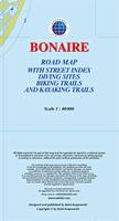
Bonaire Road Map & Guide. Approx. 1:90,000. Skyviews.
The map is a pocket tourist map, not a topographic or detailed physical map, but it is excellent at what it does. The map has an island map on the front and a listing of the best 63 dive sites on Bonaire and the best 26 dive sites on Klein Bonaire. The reverse side has a large map of Kralendijk and useful tourist information such as bike/car/taxi rental, restaurants, sites, hotels, and much more. Welcome to Bonaire!
That's exactly how visitors to Bonaire are greeted when they arrive at Flamingo Airport. And what you will have noticed too is how access to Bonaire from North America and Europe has greatly improved, making the "diver's paradise" more accessible than ever! Bonaire also is a Mecca for mountain bikers, birdwatchers and eco tourists as well. It is an ideal place to find an unspoiled environment in which to unwind and relax. A folded pocket version and a laminated flat version are available; the laminated version is ideal as a souvenir placemat. Size is 20 x 14 inches.
Sample detail from the Bonaire road map. Image of the entire Bonaire road map.
$6.99
66-33873
1 sheet, folded.
$10.99
66-33873L
1 sheet, laminated.
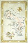
Bonaire Antique-style Wall Map. 17 x 27".
Along with Curacao, Bonaire is part of the Netherlands Antilles, located off the coast of Venezuela. With a land area of 111 square miles, the island is a growing tourist destination and center for diving. Bonaire's capital is Kralendijk, and its citizens have constitutional equality with the Netherlands.
 New map
 Thumbnail of the Bonaire map.
 Sample detail from the Bonaire map.
 Sample detail from the Bonaire map.
 Sample detail from the Kralendijk inset map.
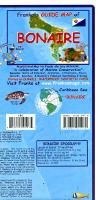
 Image of the front of the Bonaire map.
 Image of the reverse of the Bonaire map.
 Sample detail #1 from the Bonaire map.
 Sample detail #2 from the Bonaire map.
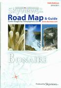
 Sample detail from the Bonaire road map.
 Image of the entire Bonaire road map.