Click here for our complete cycling maps listings.
New York State has four long-distance trails that traverse the state. These include the Adirondack Loop Trail loop; the Atlantic Coast Trail across southern New York; the Northern Tier Trail that runs from coast to coast and east-west across New York; and the Historic Underground Railroad Trail along the western state border.
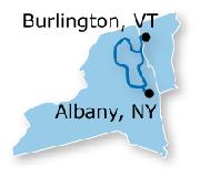
Adirondacks Loop Trail Map. Adventure Cycling Association. When ridden in a counter-clockwise direction, the Adirondack Park Loop travels from Schenectady north, crossing into Adirondack Park just north of Saratoga Springs. Adirondack Park is the largest publicly protected area in the lower forty-eight states, greater in size than Yellowstone, Everglades, Glacier and Grand Canyon National Park combined. Passing through Ticonderoga, the route hugs the western shore of Lake Champlain as it continues north. At Port Henry there is an optional spur to continue north to Port Kent, to connect to a ferry to Burlington, Vermont. The main route continues west through Lake Placid, home of the 1932 and 1980 Winter Olympic Games. The route can be somewhat hilly in the park, with climbs ranging up to 1,500 feet. The route uses lightly traveled roads with minimal shoulders. Paved shoulders prevail where traffic is moderate.
Small sketch map of the route. Detailed sketch map of the route.
62-2230-AD
1 sheet, folded.
$20.99
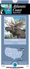
Atlantic Coast Route Series. Adventure Cycling Association. 2,525 miles -- Adventure Cycling's Atlantic Coast
route, from Bar Harbor, Maine, to Ft. Myers Beach, Florida, takes you through a region rich in history. The route passes directly through Washington, D.C. and Richmond, and is linked with spurs to Boston,
New York, Philadelphia, Baltimore, Charleston and Savannah. The Florida Connector map offers a tranquil side trip from St. Augustine to Ft. Myers Beach via the Orlando area, then on to Ft. Lauderdale, bypassing the busy A1A coastal route.
Route map.
62-2230-AC
Bar Harbor, ME to Ft. Myers Beach, FL. Set of 8 maps. 10% discount!
$120.60
62-2230-AC1
Bar Harbor, ME to Windsor Locks, CT
$16.75
62-2230-AC2
Windsor Locks, CT to Norristown, PA
$16.75
62-2230-AC3
Norristown, PA to Richmond, VA
$16.75
62-2230-AC4
Richmond, VA to Wilmington, NC
$16.75
62-2230-AC5
Wilmington, NC to Statesboro, GA
$16.75
62-2230-AC6
Statesboro, GA to St. Augustine, FL
$16.75
62-2230-AC7
St. Augustine to Key West, FL
$16.75
62-2230-AC8
Florida Connector map - St. Augustine, DisneyWorld, Ft. Myers Beach, to Ft. Lauderdale.
$16.75
Northern Tier Route
Northern Tier Route Series. Adventure Cycling Association. 4,315 miles -- From the Puget Sound to fishing villages in Maine, the Northern Tier crosses three mountain ranges - the Cascades, Rockies and
Adirondacks. Along the way the route passes through Glacier National Park, the headwaters of the Mississippi and Amish country. Discover the beauty of America by crossing the country on the Northern Tier.
Route map.
62-2230-NT
Anacortes, WA, to Bar Harbor, ME. Set of 11 maps. 10% discount!
$165.82
62-2230-NT01
Anacortes, WA, to Sandpoint, ID
$16.75
62-2230-NT02
Sandpoint, ID, to Cut Bank, MT
$16.75
62-2230-NT03
Cut Bank, MT, to Minot, ND
$16.75
62-2230-NT04
Minot, ND, to Fargo, ND
$16.75
62-2230-NT05
Fargo, ND, to Grand Rapids, MN
$16.75
62-2230-NT06
Grand Rapids, MN, to Stillwater, MN
$16.75
62-2230-NT07
Stillwater, MN, to Muscatine, IA
$16.75
62-2230-NT08
Muscatine, IA, to Monroeville, IN
$16.75
62-2230-NT09
Monroeville, IN, to Lackawanna, NY
$16.75
62-2230-NT10
Lackawanna, NY, to Ticonderoga, NY
$16.75
62-2230-NT11
Ticonderoga, NY, to Bar Harbor, ME
$16.75
Underground Railroad Bike Route
Historic Underground Railroad Bike Route. Adventure Cycling Association. Mobile, AL to Owen Sound, Ontario. 2058 miles. The Underground Railroad Bicycle Route honors the bravery of those that fled bondage and those that provided shelter. This route passes points of interest and historic sites along a 2,100-mile corridor. Beginning in Mobile, Alabama - a busy port for slavery during the pre-civil war era - the route goes north following rivers through Alabama, Mississippi, Tennessee, and Kentucky. Waterways, as well as the North Star, were often used by freedom seekers as a guide in their journeys to escape slavery.
Upon crossing into Ohio, the route leaves the river to head inland toward Lake Erie and enters Canada at the Peace Bridge near Buffalo, New York. In Ontario, the route circumvents the shores of Lake Ontario and ends at Owen Sound, a town founded by freedom seekers 150 years ago.
Route map.
62-2230-UR
Mobile, AL to Owen Sound, Ontario. Set of 5 maps. 10% discount!
 Small sketch map of the route.
 Detailed sketch map of the route.
 Route map.
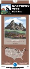
 Route map.
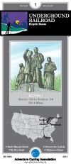
 Route map.


