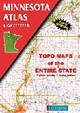
Minnesota Atlas and Gazetteer. 1:190,080. DeLorme.
Excellent road atlas with topographic maps and gazetteer. Softcover, 96 pages.
Back roads, dirt roads and trails
Elevation contours
Remote lakes and streams
Boat Ramps
Public lands for recreation
Land use / land cover - forests, wetlands, agriculture
Trailheads
Campgrounds
Prime hunting and fishing spots
$29.95
62-7548
Atlas
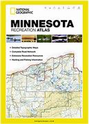
Minnesota Recreation Atlas. National Geographic Maps.
National Geographic's Minnesota Recreation Atlas is an ideal recreation resource and contains accurate, detailed topographic maps with private and public land boundaries, a complete road network, valuable recreation information and extensive cross-referenced lists and charts for campgrounds, lakes, parks, attractions and more. State Game Management Unit maps and fish species lists will appeal to the sportsman while detailed primary road networks will be of great interest to motorcyclists, RVers, and those simply touring the state.
Comprehensive, easy-to-read road network
Boundaries for parks and federal lands
Clearly-labeled lakes, rivers and streams
Durable laminated cover
Size 11"x15"
Robust travel and recreation information
Cross-referenced chart of fishing areas with species information
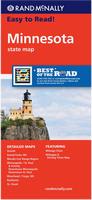
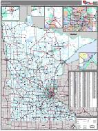
Minnesota Road Map. Rand McNally.
Rand McNally's Easy To Read State Folded Map is a must-have for anyone traveling in and around Minnesota, offering unbeatable accuracy and reliability at a great price. Our trusted cartography shows all Interstate, U.S., state, and county highways, along with clearly indicated parks, points of interest, airports, county boundaries, and streets.
The easy-to-use legend and detailed index make for quick and easy location of destinations. The map includes inset maps of Duluth, Grand Forks, ND; Mesabi Iron Range Region, Minneapolis/St. Paul & Vicinity, Downtown Minneapolis, Downtown St. Paul, Moorhead/Fargo, ND; Rochester, and St. Cloud. Map size is 28 x 40 inches unfolded.
$7.99
62-7590
1 sheet, folded.
Waterproof Minnesota Supermap Road Map. Hedberg Maps.
is map features more recreation and travel information than any other MN state map. One side includes all of Minnesota plus surrounding states and provinces. The other side includes a Super Metro map and an enhanced index and guide to golf, lakes, fishing, ski areas, and parks and trails. Map size is 33 x 38 inches unfolded.
$9.95
62-75905
1 sheet, folded.
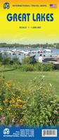
Great Lakes Travel Map. 1:1,000,000. ITMB.
Using this map, one can explore Lakes Ontario and Erie as circular routes; also Huron and Superior; visit Ottawa and Toronto, Chicago and Duluth, and find Fort WilliamWawa Goose. This is a double-sided map covering from Ottawa in the north to Pittsburgh and Columbus in the south and Duluth and Thunder Bay in the west. Both Canada and the USA portions of the Great Lakes Region are included.
Sample detail of the Great Lakes Travel Map
$9.95
62-20913-GL
1 sheet, folded.
$24.99
62-20913-GLW
1 sheet, flat.
$34.99
62-20913-GLL
1 sheet, laminated.
Minnesota Road Maps - Waterproof Maps
Laminated Minnesota Road Maps - Laminated Map. Rand McNally.
The durable and convenient Minnesota EasyToFold state map will take all the wear and tear your journey can dish out. The heavy-duty laminated design allows you to mark your route, make notes, then wipe the surface clean for further use. Map size is 18 x 17 inches unfolded.
$9.99
62-75903
1 sheet, folded.
Minnesota City Maps
Minneapolis & St. Paul PopOut Map. PopOut.
Pocket-sized "pop-out" origami-style map that covers the Minneapolis and St. Paul area. With detailed map of city-center and an overview of the Twin Cities.
$6.95
62-7592MK
1 sheet, folded.
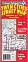
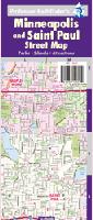
Twin Cities (Minneapolis & St. Paul) Street Map. Hedberg.
Covering the I-494-694 loop, including the entire cities of Minneapolis and St Paul, this detailed map shows streets, parks, schools, shopping, trails, government offices and an amazing wealth of points of interest.
Sample detail of the Twin Cities city map
$5.99
62-7592TW
1 sheet, folded.
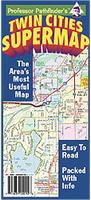
Twin Cities (Minneapolis & St. Paul) Supermap. Hedberg.
The Twin Cities Super Map includes great detail of the greater metro area, showing major roads and an amazing variety of points of interest. The best map available for navigating the Twin Cities Metro area!
Sample detail of the Twin Cities city map Image of the Twin Cities Supermap
$6.95
62-7592TWS
1 sheet, folded.
Minneapolis - St. Paul Metro Area Map Set. Hedberg.
$5.99
62-7592MIE
(MN) Minneapolis & St. Paul East section street map. (Hedberg).
$5.99
62-7592MIW
(MN) Minneapolis & St. Paul West section street map. (Hedberg).
$5.99
62-7592MIN
(MN) Minneapolis & St. Paul North section street map. (Hedberg).
$5.99
62-7592MIS
(MN) Minneapolis & St. Paul South section street map. (Hedberg).
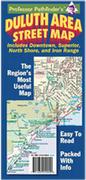
Duluth street map. (Hedberg). The most complete map of the Twin Harbors area. Detailed street map includes surrounding suburbs. A downtown map shows every building in the core, colored and labeled by use. A map of the North Shore and Boundary Waters area includes recreation information. A comprehensive Iron Range regional map and campus maps of three area colleges round out the piece.
$5.99
62-7592M
Highways of Minneapolis & St. Paul Area Map. (Rand McNally). The map also covers Brooklyn Park, Burnsville, Eagan, Eden Prairie, Cottage Grove, Maple Grove, Minnetonka, Plymouth, Roseville, and Woodbury.
$3.95
62-7592RE
Red Wing, Lake Pepin, Cannon Falls street map. (Hedberg).
$5.99
62-9592ARL
Rochester Street Map. 2010. Also includes Winona, Red Wing, and Wabasha. (Seeger).
$4.95
62-7592SC
St. Cloud city street map. (Hedberg).
$6.95
62-7592SM
Southern Minnesota city street map. (Hedberg).
$4.95
62-7592SP
St. Paul city street map. (Rand McNally).
Minnesota City Maps - Laminated Maps.
Laminated Duluth Laminated Street Map. Hedberg.
This is a handy, compact format. Includes a street map of most of the city of Duluth, a building-level detail of downtown Duluth, a street map of Superior, Wisconsin, and a handy map of the North Shore area.
$7.95
62-75921DU
1 sheet, folded, laminated.
Laminated Mankato and New Ulm Laminated Street Map. Hedberg.
Also covers St. Peter and Waseca. This map is out of print and we have limited stock left.
$6.95
62-7592MAN
1 sheet, folded, laminated.
Laminated Minneapolis & St. Paul Area Laminated Street Map. Hedberg.
Complete street map of Minneapolis and St Paul in a handy, compact format. includes schools, parks, shopping, and points of interest. Includes details of the downtowns, and a full index of points of interest, parks and major streets.
$8.99
62-75921MSP
1 sheet, folded, laminated.
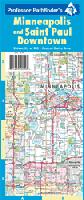
Laminated Minneapolis & St. Paul Downtowns Laminated Street Map. Hedberg.
Excellent detail of both of Twin Cities' downtowns. Every building color coded by use. Major restaurants named. Includes a core metro map to get you around, and a map of the University area. Fully indexed. Perfect for the out-of-town conventioneersuburban shopper!
$8.99
62-75921MSPD
1 sheet, folded, laminated.
Minnesota City Wall Maps
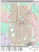
Minnesota City Wall Maps.
When it comes to general planning, defining delivery areas, planning direct marketing and delivering products, our city wall maps are perfect to get the detailed information you need.
These maps offer clear mapping by showing all major streets and roads and many of the smaller streets, but leaving out the smallest streets. If you want a clear map for easy planning, then these are the maps for you; if you want a map showing every little back alley, these are not for you.
We offer wall maps for Apple Valley, Blaine, Bloomington, Brooklyn Park, Burnsville, Coon Rapids, Duluth, Eagan, Eden Prairie, Lakeville, Maple Grove, Minneapolis, Minnetonka,
Plymouth, Rochester, St. Cloud, St. Paul, and Woodbury.
Click here to order and to see sample images, prices, sizes, and mounting options.
Minnesota Bicycling Maps. Minnesota has a major long-distance trail that traverses the state - the Northern Tier TransAmerica Cycling Trail that goes east-west across Minnesota. There are numerous other cycling trails covered in the state cycling map and guide.
Click here for our complete US Forest Service maps list.
Minnesota Wall Maps
Minnesota State and County Wall Maps. Intelligent Direct.
We offer state and county wall maps for all of the USA. The maps come in sizes from 24 x 36 to 108 x 144 inches. They are available in variety of mounting and framing options. The maps are ideal for business applications, sales territory, delivery planning, direct mail targeting and hundreds of other applications.
Click here to order county wall maps and to see sample images, descriptions, and prices.
Click here to order state wall maps and to see sample images, descriptions, and prices.
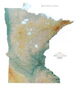
Minnesota Shaded Relief Wall Map. 1:600,000. Size is 41" x 49". Most of the state was formed into gently rolling plains when glaciers moved over the land during the last Ice Age. Minnesota is known for being the Land of 10,000 Lakes. Elevations are represented by color, and this, in combination with our relief shading technique, gives the map a 3-dimensional look.
Thumbnail of the map. Sample of the detail.
1:250,000 Bouguer Gravity Anomaly Regional Maps of Minnesota. 1:250,000. Minnesota Geological Survey. This series offers more detail than the single-sheet bouguer gravity map listed above.
$7.95
62-7513D
Brainerd quadrangle.
$7.95
62-7513E
Duluth quadrangle.
$7.95
62-7513F
Hibbing quadrangle.
$7.95
62-7513G
International Falls quadrangle.
$9.95
62-7513H
New Ulm quadrangle.
$7.95
62-7513J
Roseau quadrangle.
$9.95
62-7513K
St. Cloud quadrangle.
$10.95
62-7513L
St. Paul quadrangle.
$9.95
62-7513M
Stillwater quadrangle.
$7.95
62-7513N
Two Harbors quadrangle.
Minnesota Seismicity Map. 1:1,000,000. 1981. USGS (MF-1323). Map size is 79 x 104 cm.
$9.95
62-7515
1 sheet, folded
Minnesota Bedrock Hydrogeology Map. 1:500,000. 1979. Minnesota Geological Survey. This map illustrates the composition and extent of the basement aquifers. The map comes complete with a separate cross section sheet and 11-page text. In color, size 125 x 142 cm.
$14.95
62-7535
Set, folded
1:250,000 Geological Regional Maps of Minnesota. 1:250,000. Minnesota Geological Survey. Detailed regional geology maps of Minnesota.
$7.95
62-7555D
New Ulm quadrangle.
$14.95
62-7555E
Roseau quadrangle.
$7.95
62-7555F
St. Paul quadrangle.
$15.95
62-7555G
Two Harbors quadrangle.
Map of the Cretaceous Rocks of Southwest Minnesota. Minnesota Geological Survey.
$10.95
62-7566
1 sheet, folded
Assorted Geological Maps of Minnesota. 1:250,000. Minnesota Geological Survey. Detailed regional geology maps of Minnesota.


 Sample detail from the Minnesota recreation atlas
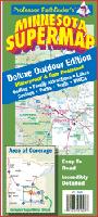 Waterproof
 Sample detail of the Great Lakes Travel Map
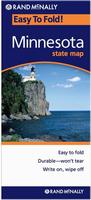 Laminated

 Sample detail of the Twin Cities city map
 Sample detail of the Twin Cities city map
 Image of the Twin Cities Supermap
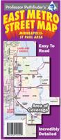
 Sample detail of the Duluth city map
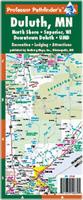 Laminated
 Laminated
 Laminated
 Laminated
 Sample detail from the Minneapolis wall map.

 Minnesota State and County Wall Maps. Intelligent Direct.
 Thumbnail of the map.
 Sample of the detail.
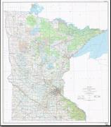 Minnesota Topographic Map. 1:500,000. 1985. USGS. Map size is 124 x 142 cm.
 Sample detail from the Minnesota topographic map.
 Image of the Minnesota topographic map.
 Minnesota Flags