New Jersey Lake Fishing Maps by Fishing Hot Spots are superb maps showing the lake bottoms for hundreds of lakes and rivers across the USA. These maps are printed on either kimdura or Hop-syn (both tear-resistent waterproof synthetic materials), making them nearly indestructible. The maps show lake bottom contours, shoreline features, roads leading to the lakes, boating facilities along the lake shore, and much more.
Fishing Map sample Enlargement
62-8293-A303
Greenwood Lake fishing map.
$13.95
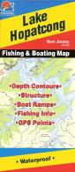
62-8293-A304
Lake Hopatcong fishing map.
$13.95
62-8293-A305
Round Valley Lake fishing map.
$14.95
62-8293-A306
Spruce Run Reservoir fishing map.
$13.95
New Jersey Saltwater Fishing Maps by Fishing Hot Spots. Waterproof, tear-resistant fishing maps covering the New Jersey coastline. Some of these coastal maps are going out of print and will not be available once our current inventory is sold out.
62-8293-NJ0102
Atlantic City - Ocean City to Barnegat Inlet fishing map.
$16.95
62-8293-NJ0103
Barnegat - Barnegat Inlet to Deal fishing map.
$19.95
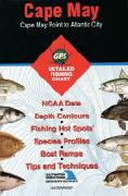
62-8293-NJ0101
Cape May - Cape May to Atlantic City fishing map.
$19.95
62-8293-NJ0104
New York Bight - Raritan Bay to Atlantic Ocean fishing map.
 New Jersey Lake Fishing Maps by Fishing Hot Spots are superb maps showing the lake bottoms for hundreds of lakes and rivers across the USA. These maps are printed on either kimdura or Hop-syn (both tear-resistent waterproof synthetic materials), making them nearly indestructible. The maps show lake bottom contours, shoreline features, roads leading to the lakes, boating facilities along the lake shore, and much more.
 Fishing Map sample
 Enlargement