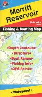
Nebraska Fishing Maps by Fishing Hot Spots are superb maps showing the lake bottoms for hundreds of lakes and rivers across the USA. These maps are printed on either kimdura or Hop-syn (both tear-resistent waterproof synthetic materials), making them nearly indestructible. The maps show lake bottom contours, shoreline features, roads leading to the lakes, boating facilities along the lake shore, and much more.
Fishing Map sample Enlargement
62-7993-A280
Harlan County Reservoir
$13.95
Fish-N-Map Company underwater topography maps are printed on a
waterproof, tear-resistant material and are folded to 9" x 4". When opened, each map is approximately
3' x 2' in size and is printed on both sides. These maps feature waterproof plastic "paper"; underwater
depth contours; fish locations; latitude and longitude for GPS; often multiple lakes on one map; boat
ramps; recreational facilities; and much more.
 Fishing Map sample
 Enlargement